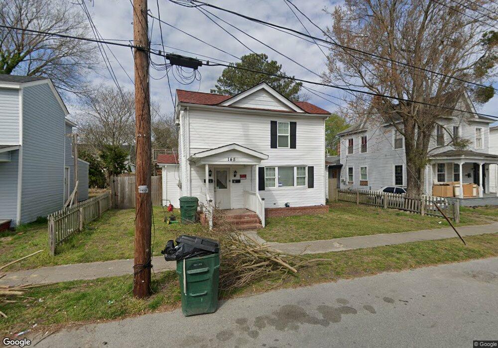
145 Lee St Suffolk, VA 23434
Downtown Suffolk NeighborhoodEstimated Value: $213,837 - $305,000
4
Beds
2
Baths
2,204
Sq Ft
$120/Sq Ft
Est. Value
About This Home
This home is located at 145 Lee St, Suffolk, VA 23434 and is currently estimated at $265,459, approximately $120 per square foot. 145 Lee St is a home located in Suffolk City with nearby schools including Hillpoint Elementary School, King's Fork Middle School, and King's Fork High School.
Ownership History
Date
Name
Owned For
Owner Type
Purchase Details
Closed on
Dec 5, 2016
Sold by
D & F Properties And Builders Incorporat
Bought by
Rp Enterprise Llc A Virginia Limited Lia
Current Estimated Value
Purchase Details
Closed on
Mar 11, 2010
Sold by
Aurora Loan Services Llc
Bought by
D And F Properties And Builder
Home Financials for this Owner
Home Financials are based on the most recent Mortgage that was taken out on this home.
Original Mortgage
$50,000
Interest Rate
5.02%
Mortgage Type
Land Contract Argmt. Of Sale
Create a Home Valuation Report for This Property
The Home Valuation Report is an in-depth analysis detailing your home's value as well as a comparison with similar homes in the area
Home Values in the Area
Average Home Value in this Area
Purchase History
| Date | Buyer | Sale Price | Title Company |
|---|---|---|---|
| Rp Enterprise Llc A Virginia Limited Lia | $16,500 | Attorney | |
| D And F Properties And Builder | $40,000 | -- |
Source: Public Records
Mortgage History
| Date | Status | Borrower | Loan Amount |
|---|---|---|---|
| Previous Owner | D And F Properties And Builder | $50,000 |
Source: Public Records
Tax History Compared to Growth
Tax History
| Year | Tax Paid | Tax Assessment Tax Assessment Total Assessment is a certain percentage of the fair market value that is determined by local assessors to be the total taxable value of land and additions on the property. | Land | Improvement |
|---|---|---|---|---|
| 2024 | $2,123 | $119,400 | $46,100 | $73,300 |
| 2023 | $1,974 | $113,700 | $43,900 | $69,800 |
| 2022 | $985 | $90,400 | $31,300 | $59,100 |
| 2021 | $935 | $84,200 | $25,100 | $59,100 |
| 2020 | $909 | $81,900 | $22,800 | $59,100 |
| 2019 | $909 | $81,900 | $22,800 | $59,100 |
| 2018 | $1,129 | $82,100 | $22,800 | $59,300 |
| 2017 | $878 | $82,100 | $22,800 | $59,300 |
| 2016 | $878 | $82,100 | $22,800 | $59,300 |
| 2015 | $640 | $82,100 | $22,800 | $59,300 |
| 2014 | $640 | $82,100 | $22,800 | $59,300 |
Source: Public Records
Map
Nearby Homes
- 144 Lee St
- 152 Lee St
- 124 Wellons St
- 434 Jackson St
- 128 Wellons St
- 214 Wellons St
- 118 Saint James Ave
- 212 Saint James Ave
- 312 Saint James Ave
- 313 Saint James Ave
- 308 Linden Ave
- 105 Brewer Ave
- 406 Saint James Ave
- 301 Linden Ave
- 118 S Broad St
- 419 Wellons St
- 223 Clay St
- 215 N Saratoga St
- 309 Linden Ave
- 222 Clay St