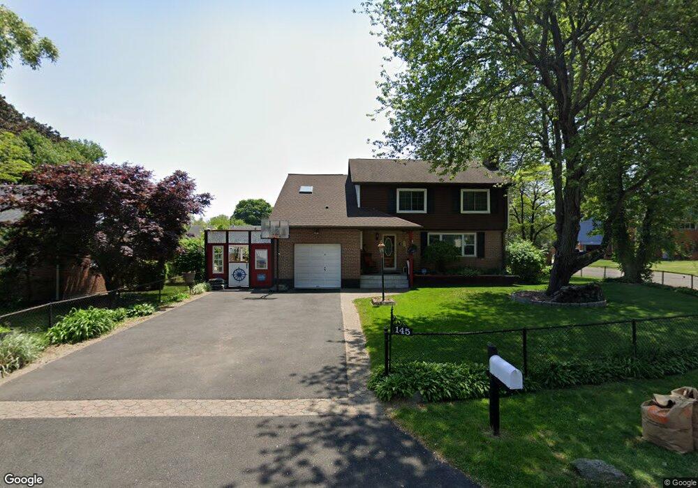
145 Loftus Cir Bridgeport, CT 06606
North End NeighborhoodEstimated Value: $454,000 - $544,000
4
Beds
2
Baths
1,918
Sq Ft
$265/Sq Ft
Est. Value
About This Home
This home is located at 145 Loftus Cir, Bridgeport, CT 06606 and is currently estimated at $508,402, approximately $265 per square foot. 145 Loftus Cir is a home located in Fairfield County with nearby schools including John Winthrop School, Central High School, and St Andrew School.
Ownership History
Date
Name
Owned For
Owner Type
Purchase Details
Closed on
Jan 6, 2025
Sold by
Dunn Mark and Dunn Nadine
Bought by
Dunn T T and Dunn D
Current Estimated Value
Purchase Details
Closed on
Feb 28, 2005
Sold by
Aurora Loan Service
Bought by
Dunn Mark and Dunn Nadine
Purchase Details
Closed on
Dec 27, 2001
Sold by
Hathaway William S and Hathaway Andrea
Bought by
Anilus Jean
Create a Home Valuation Report for This Property
The Home Valuation Report is an in-depth analysis detailing your home's value as well as a comparison with similar homes in the area
Home Values in the Area
Average Home Value in this Area
Purchase History
| Date | Buyer | Sale Price | Title Company |
|---|---|---|---|
| Dunn T T | -- | None Available | |
| Dunn T T | -- | None Available | |
| Dunn Mark | $260,000 | -- | |
| Anilus Jean | $234,900 | -- | |
| Dunn Mark | $260,000 | -- | |
| Anilus Jean | $234,900 | -- |
Source: Public Records
Mortgage History
| Date | Status | Borrower | Loan Amount |
|---|---|---|---|
| Previous Owner | Anilus Jean | $210,700 | |
| Previous Owner | Anilus Jean | $246,627 |
Source: Public Records
Tax History
| Year | Tax Paid | Tax Assessment Tax Assessment Total Assessment is a certain percentage of the fair market value that is determined by local assessors to be the total taxable value of land and additions on the property. | Land | Improvement |
|---|---|---|---|---|
| 2025 | $9,306 | $214,180 | $78,550 | $135,630 |
| 2024 | $9,306 | $214,180 | $78,550 | $135,630 |
| 2023 | $9,306 | $214,180 | $78,550 | $135,630 |
| 2022 | $9,306 | $214,180 | $78,550 | $135,630 |
| 2021 | $9,306 | $214,180 | $78,550 | $135,630 |
| 2020 | $9,874 | $182,880 | $61,540 | $121,340 |
| 2019 | $9,874 | $182,880 | $61,540 | $121,340 |
| 2018 | $9,943 | $182,880 | $61,540 | $121,340 |
| 2017 | $9,943 | $182,880 | $61,540 | $121,340 |
| 2016 | $9,943 | $182,880 | $61,540 | $121,340 |
| 2015 | $9,133 | $216,420 | $67,520 | $148,900 |
| 2014 | $9,133 | $216,420 | $67,520 | $148,900 |
Source: Public Records
Map
Nearby Homes
- 3432 Old Town Rd
- 3460 Old Town Rd
- 3125 Old Town Rd
- 69 Seaver Cir
- 170 Marilyn Dr
- 105 Daniel Dr
- 217 Macon Dr
- 99 Quinsey Dr
- 8 Raleigh Rd
- 121 Campbell Rd
- 252 Bear Paw Rd
- 18 Ridgebury Dr
- 3370 Madison Ave Unit 10B
- 110 Minturn Rd
- 114 Minturn Place
- lot 194 Prospect Ave
- 50 Greenhouse Rd Unit 65D
- 50 Greenhouse Rd Unit 49C
- 50 Greenhouse Rd Unit 33D
- 50 Greenhouse Rd Unit 33C
Your Personal Tour Guide
Ask me questions while you tour the home.