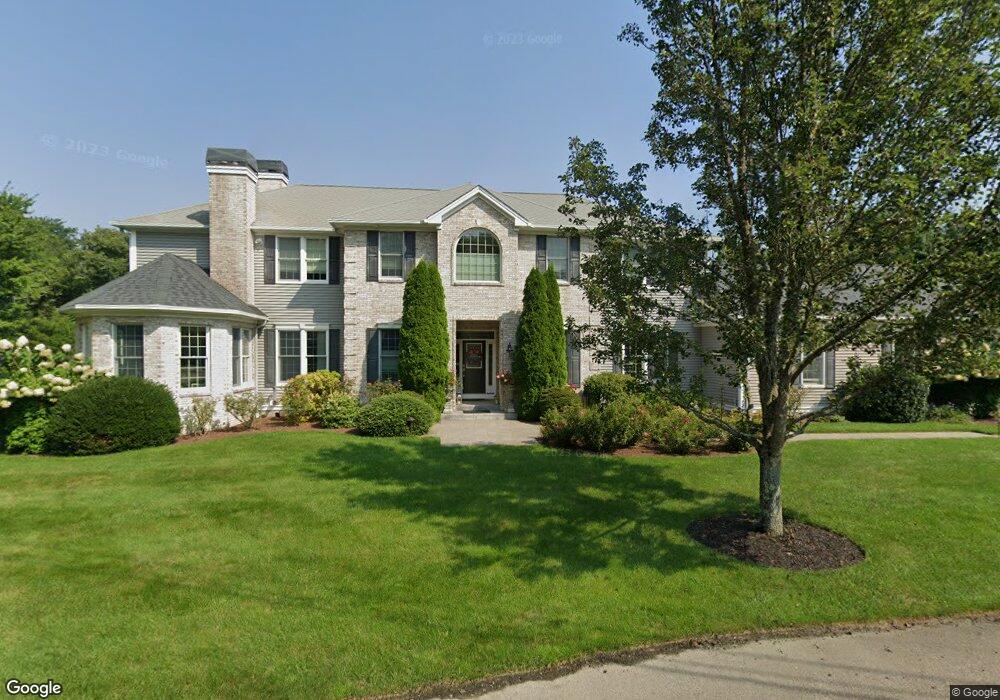
145 S Pier Rd Narragansett, RI 02882
Estimated Value: $2,065,000 - $2,702,000
4
Beds
5
Baths
5,040
Sq Ft
$467/Sq Ft
Est. Value
About This Home
This home is located at 145 S Pier Rd, Narragansett, RI 02882 and is currently estimated at $2,351,865, approximately $466 per square foot. 145 S Pier Rd is a home located in Washington County with nearby schools including Narragansett Elementary School, Narragansett Pier Middle School, and Narragansett High School.
Ownership History
Date
Name
Owned For
Owner Type
Purchase Details
Closed on
Sep 13, 2012
Sold by
Kenny Richard J and Kenny Mary F
Bought by
Richard J Kenny T and Kenny Richard J
Current Estimated Value
Purchase Details
Closed on
Jul 26, 2004
Sold by
Orrico John C and Orrico Maureen L
Bought by
Kenny Richard J and Kenny Mary F
Home Financials for this Owner
Home Financials are based on the most recent Mortgage that was taken out on this home.
Original Mortgage
$225,600
Interest Rate
6.28%
Mortgage Type
Purchase Money Mortgage
Create a Home Valuation Report for This Property
The Home Valuation Report is an in-depth analysis detailing your home's value as well as a comparison with similar homes in the area
Home Values in the Area
Average Home Value in this Area
Purchase History
| Date | Buyer | Sale Price | Title Company |
|---|---|---|---|
| Richard J Kenny T | -- | -- | |
| Kenny Richard J | $282,000 | -- |
Source: Public Records
Mortgage History
| Date | Status | Borrower | Loan Amount |
|---|---|---|---|
| Previous Owner | Kenny Richard J | $400,000 | |
| Previous Owner | Kenny Richard J | $835,000 | |
| Previous Owner | Kenny Richard J | $1,000,000 | |
| Previous Owner | Kenny Richard J | $225,600 |
Source: Public Records
Tax History Compared to Growth
Tax History
| Year | Tax Paid | Tax Assessment Tax Assessment Total Assessment is a certain percentage of the fair market value that is determined by local assessors to be the total taxable value of land and additions on the property. | Land | Improvement |
|---|---|---|---|---|
| 2025 | $13,987 | $2,060,000 | $730,800 | $1,329,200 |
| 2024 | $13,493 | $2,060,000 | $730,800 | $1,329,200 |
| 2023 | $12,825 | $1,377,500 | $498,600 | $878,900 |
| 2022 | $12,398 | $1,377,500 | $498,600 | $878,900 |
| 2021 | $12,205 | $1,377,500 | $498,600 | $878,900 |
| 2020 | $11,186 | $1,067,400 | $376,800 | $690,600 |
| 2019 | $10,920 | $1,067,400 | $376,800 | $690,600 |
| 2018 | $10,621 | $1,067,400 | $376,800 | $690,600 |
| 2017 | $11,213 | $1,061,800 | $348,000 | $713,800 |
| 2016 | $10,703 | $1,061,800 | $348,000 | $713,800 |
| 2015 | $10,554 | $1,061,800 | $348,000 | $713,800 |
| 2014 | $10,508 | $1,046,600 | $348,000 | $698,600 |
Source: Public Records
Map
Nearby Homes
- 140 S Pier Rd
- 126 Boon St
- 16 Courtway St
- 49 Westmoreland St
- 137 Kingstown Rd
- 137A Kingstown Rd
- 27 Westmoreland St
- 56 Wanda St
- 20 Narragansett Ave Unit 905
- 30 Sweet Meadows Ct Unit 26
- 0 Hazard Ave
- 6 Pendleton Place
- 38 Eisenhower Place
- 128 Camden Ct
- 19 Castle Rd
- 73 Camden Ct
- 45 Cherry Ln Unit C
- 39 Hazard Ave
- 576 Point Judith Rd
- 98 Meadow Ave
- 6 Blossom Way
- 8 Blossom Way
- 151 S Pier Rd
- 4 Blossom Way
- 0 Blossom Way Unit 1371164
- 0 Blossom Way Unit 1350611
- 0 Blossom Way Unit 1340258
- 0 Blossom Way
- 149 S Pier Rd
- 0 Black Alder Trail Unit 108282
- 0 Black Alder Trail Unit 103273
- 0 Black Alder Trail Unit 632137
- 0 Black Alder Trail Unit 9081
- 0 Black Alder Trail Unit 754247
- 0 Black Alder Trail Unit 540675
- 0 Black Alder Trail Unit 830677
- 0 Black Alder Trail Unit 930569
- 0 Black Alder Trail Unit 996804
- 0 Ouida St Unit 1011594
- 0 Devigne St Unit 1011593