

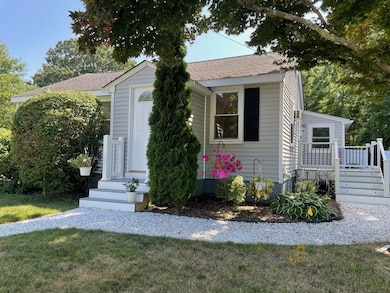


145 S Worcester St Norton, MA 02766
Estimated payment $3,268/month
Highlights
- Golf Course Community
- Deck
- Ranch Style House
- Medical Services
- Vaulted Ceiling
- Wood Flooring
About This Home
Back on Market! Welcome to this well maintained THREE-bedroom ranch style home on a 1/2-acre level lot. This home offers 1,620 sf of living space that has been recently painted w/ new carpeting installed, that includes a large living rm space w/ hardwood floor, dining area, kitchen w/ granite counter tops & an island which is adjacent to a spacious family room w/ access to a large rear deck. Large primary bedroom w/ vaulted ceiling, access to rear porch & yard, walk-in cedar closet & primary bathroom that has a refinished shower. There are 2 additional bedrooms w/ ceiling fans & 2nd Full bathroom. Also, a front porch off the kitchen. There are 2 basements that offer lots of additional storage & laundry. Spacious fenced in back yard for entertaining w/ a large shed & large driveway for plenty of parking. Shed for additional storage. Recent updates include roof (2020), vinyl fence (2020), hot water heater (2019) & new sump pump.
Home Details
Home Type
- Single Family
Est. Annual Taxes
- $5,731
Year Built
- Built in 1947
Home Design
- Ranch Style House
- Block Foundation
- Shingle Roof
- Concrete Perimeter Foundation
Interior Spaces
- 1,620 Sq Ft Home
- Vaulted Ceiling
- Ceiling Fan
- Recessed Lighting
- Insulated Windows
- Picture Window
Kitchen
- Stove
- Range
- Microwave
- Dishwasher
- Kitchen Island
- Solid Surface Countertops
Flooring
- Wood
- Wall to Wall Carpet
- Ceramic Tile
Bedrooms and Bathrooms
- 3 Bedrooms
- Cedar Closet
- Walk-In Closet
- 2 Full Bathrooms
- Bathtub with Shower
- Separate Shower
Laundry
- Dryer
- Washer
Unfinished Basement
- Basement Fills Entire Space Under The House
- Interior Basement Entry
- Sump Pump
- Block Basement Construction
- Laundry in Basement
Parking
- 4 Car Parking Spaces
- Driveway
- Paved Parking
- Open Parking
- Off-Street Parking
Outdoor Features
- Bulkhead
- Deck
- Outdoor Storage
- Rain Gutters
Utilities
- Window Unit Cooling System
- 2 Heating Zones
- Baseboard Heating
- Gas Water Heater
- Private Sewer
- Cable TV Available
Additional Features
- 0.5 Acre Lot
- Property is near schools
Listing and Financial Details
- Assessor Parcel Number 2925618
Community Details
Overview
- No Home Owners Association
Amenities
- Medical Services
- Shops
- Coin Laundry
Recreation
- Golf Course Community
- Park
Map
Home Values in the Area
Average Home Value in this Area
Tax History
| Year | Tax Paid | Tax Assessment Tax Assessment Total Assessment is a certain percentage of the fair market value that is determined by local assessors to be the total taxable value of land and additions on the property. | Land | Improvement |
|---|---|---|---|---|
| 2025 | $57 | $441,900 | $173,300 | $268,600 |
| 2024 | $5,451 | $420,900 | $165,000 | $255,900 |
| 2023 | $5,206 | $400,800 | $155,700 | $245,100 |
| 2022 | $5,039 | $353,400 | $141,500 | $211,900 |
| 2021 | $0 | $310,200 | $134,800 | $175,400 |
| 2020 | $216 | $301,300 | $130,800 | $170,500 |
| 2019 | $230 | $282,700 | $119,300 | $163,400 |
| 2018 | $4,046 | $266,900 | $119,300 | $147,600 |
| 2017 | $3,908 | $257,800 | $119,300 | $138,500 |
| 2016 | $3,651 | $233,900 | $119,200 | $114,700 |
| 2015 | $3,521 | $228,800 | $116,900 | $111,900 |
| 2014 | $3,374 | $219,500 | $111,300 | $108,200 |
Property History
| Date | Event | Price | List to Sale | Price per Sq Ft |
|---|---|---|---|---|
| 11/24/2025 11/24/25 | Pending | -- | -- | -- |
| 11/11/2025 11/11/25 | For Sale | $529,900 | 0.0% | $327 / Sq Ft |
| 11/04/2025 11/04/25 | Pending | -- | -- | -- |
| 10/29/2025 10/29/25 | For Sale | $529,900 | 0.0% | $327 / Sq Ft |
| 09/07/2025 09/07/25 | Pending | -- | -- | -- |
| 08/19/2025 08/19/25 | For Sale | $529,900 | -- | $327 / Sq Ft |
Purchase History
| Date | Type | Sale Price | Title Company |
|---|---|---|---|
| Deed | $125,000 | -- | |
| Deed | -- | -- | |
| Foreclosure Deed | $259,542 | -- | |
| Deed | -- | -- |
Mortgage History
| Date | Status | Loan Amount | Loan Type |
|---|---|---|---|
| Open | $156,877 | FHA |
Source: MLS Property Information Network (MLS PIN)
MLS Number: 73419865
APN: NORT-000027-000000-000200
Disclaimer: Certain information contained herein is derived from information provided by parties other than Homes.com. All information provided is deemed reliable, but is not guaranteed to be accurate and should be independently verified.
![]() The property listing data and information, or the Images, set forth herein were provided to MLS Property Information Network, Inc. from third party sources, including sellers, lessors and public records, and were compiled by MLS Property Information Network, Inc. The property listing data and information, and the Images, are for the personal, non-commercial use of consumers having a good faith interest in purchasing or leasing listed properties of the type displayed to them and may not be used for any purpose other than to identify prospective properties which such consumers may have a good faith interest in purchasing or leasing. MLS Property Information Network, Inc. and its subscribers disclaim any and all representations and warranties as to the accuracy of the property listing data and information, or as to the accuracy of any of the Images, set forth herein.
The property listing data and information, or the Images, set forth herein were provided to MLS Property Information Network, Inc. from third party sources, including sellers, lessors and public records, and were compiled by MLS Property Information Network, Inc. The property listing data and information, and the Images, are for the personal, non-commercial use of consumers having a good faith interest in purchasing or leasing listed properties of the type displayed to them and may not be used for any purpose other than to identify prospective properties which such consumers may have a good faith interest in purchasing or leasing. MLS Property Information Network, Inc. and its subscribers disclaim any and all representations and warranties as to the accuracy of the property listing data and information, or as to the accuracy of any of the Images, set forth herein.
- 170 S Worcester St Unit 3
- 178 S Worcester St
- 225 S Worcester St Unit 1
- 225 S Worcester St Unit 2
- 108 S Worcester St
- 182 John Scott Blvd
- 75 Barrows St
- 48 Dean St
- 38 Danielle St
- 16 Park Ln
- 127 John Scott Blvd
- 125 John Scott Blvd
- 55 Sturdy St
- 53 Sturdy St
- 4 Colonial Dr Unit 4
- 8 Kasmira Way
- 64 Ridgehill Rd
- 19 Precourt Ln
- 3 Lloyd Cir Unit 43
- 20 Lloyd Cir Unit 32
