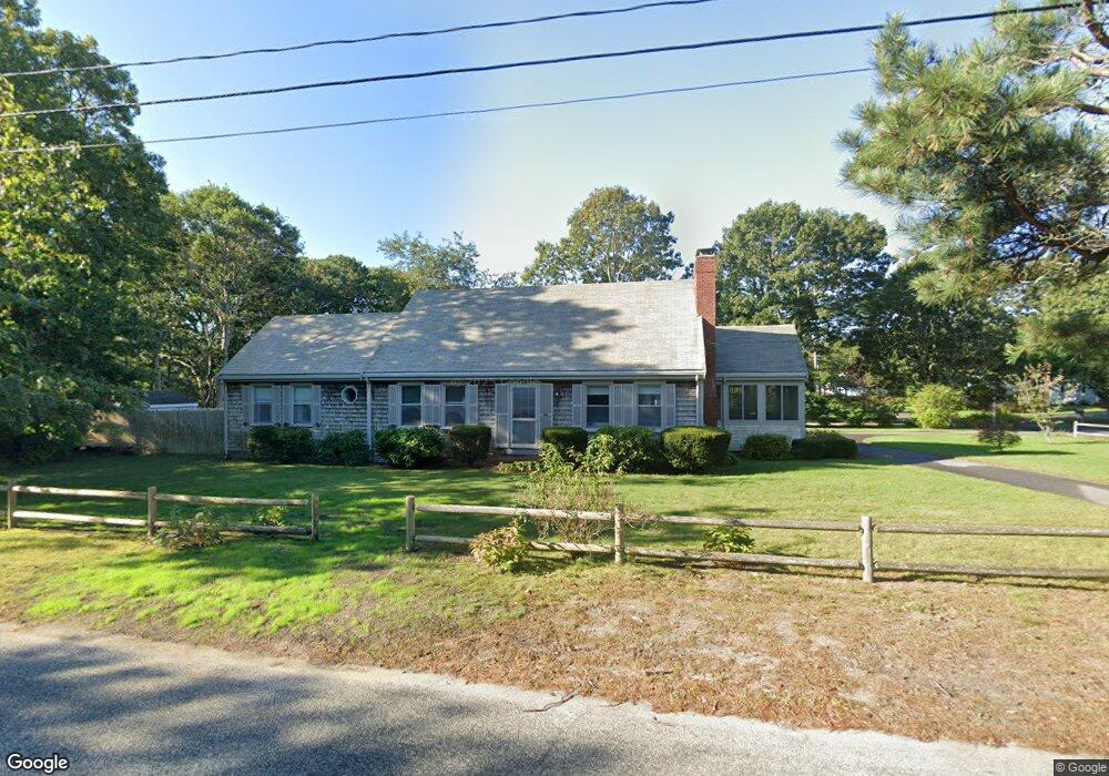
145 Silverleaf Ln West Yarmouth, MA 02673
West Yarmouth NeighborhoodEstimated Value: $738,000 - $982,000
4
Beds
3
Baths
1,729
Sq Ft
$492/Sq Ft
Est. Value
About This Home
This home is located at 145 Silverleaf Ln, West Yarmouth, MA 02673 and is currently estimated at $849,855, approximately $491 per square foot. 145 Silverleaf Ln is a home located in Barnstable County with nearby schools including Dennis-Yarmouth Regional High School, Sturgis Charter Public School, and Kiddie Kollege Early Learning Center.
Ownership History
Date
Name
Owned For
Owner Type
Purchase Details
Closed on
Sep 22, 2020
Sold by
Lynds Susan B
Bought by
Lynds Ft
Current Estimated Value
Purchase Details
Closed on
Dec 20, 2017
Sold by
Paterson Barbara A
Bought by
Lynds Susan B
Purchase Details
Closed on
Dec 10, 2012
Sold by
Peterson Ft
Bought by
Lynds Susan B
Purchase Details
Closed on
Dec 19, 2006
Sold by
Paterson Rt
Bought by
Paterson Barbara A and Paterson Norman I
Create a Home Valuation Report for This Property
The Home Valuation Report is an in-depth analysis detailing your home's value as well as a comparison with similar homes in the area
Home Values in the Area
Average Home Value in this Area
Purchase History
| Date | Buyer | Sale Price | Title Company |
|---|---|---|---|
| Lynds Ft | -- | None Available | |
| Lynds Susan B | -- | -- | |
| Lynds Susan B | -- | -- | |
| Paterson Barbara A | -- | -- |
Source: Public Records
Tax History Compared to Growth
Tax History
| Year | Tax Paid | Tax Assessment Tax Assessment Total Assessment is a certain percentage of the fair market value that is determined by local assessors to be the total taxable value of land and additions on the property. | Land | Improvement |
|---|---|---|---|---|
| 2025 | $5,183 | $732,100 | $269,900 | $462,200 |
| 2024 | $4,793 | $649,400 | $234,700 | $414,700 |
| 2023 | $4,666 | $575,400 | $198,100 | $377,300 |
| 2022 | $4,245 | $462,400 | $177,400 | $285,000 |
| 2021 | $4,191 | $438,400 | $177,400 | $261,000 |
| 2020 | $4,038 | $403,800 | $174,200 | $229,600 |
| 2019 | $3,799 | $376,100 | $174,200 | $201,900 |
| 2018 | $3,765 | $365,900 | $164,000 | $201,900 |
| 2017 | $3,649 | $364,200 | $164,000 | $200,200 |
| 2016 | $3,635 | $364,200 | $164,000 | $200,200 |
| 2015 | $3,533 | $351,900 | $164,000 | $187,900 |
Source: Public Records
Map
Nearby Homes
- 16 Yacht Ave
- 21 Heritage Dr
- 32 Schooner St
- 21 Schooner St
- 29 Winchester Ave
- 6 New Hampshire Ave Unit D
- 503 Route 28 Unit 25
- 286 S Sea Ave
- 4 Columbus Ave
- 85 Baker Rd
- 32 Wimbledon Dr
- 107 Wimbledon Dr
- 54 Boxberry Ln
- 15 Mayflower Rd
- 15 Webster Rd
- 2 Candlewood Ln
- 55 Pawkannawkut Dr
- 9 Roberta Dr
- 109 Seaview Ave Unit 11
- 0 Ken's Way
- 146 Springer Ln
- 132 Springer Ln
- 73 Crowell Rd
- 127 Silverleaf Ln
- 150 Springer Ln
- 145 Springer Ln
- 61 Crowell Rd
- 81 Crowell Rd
- 130 Silverleaf Ln
- 149 Springer Ln
- 126 Springer Ln
- 156 Springer Ln
- 83 Crowell Rd
- 305 Crowell Rd
- 0 Crowell Rd
- 119113 Crowell Rd
- 121 Silverleaf Ln
- 125 Springer Ln
- 124 Silverleaf Ln
- 70 Crowell Rd