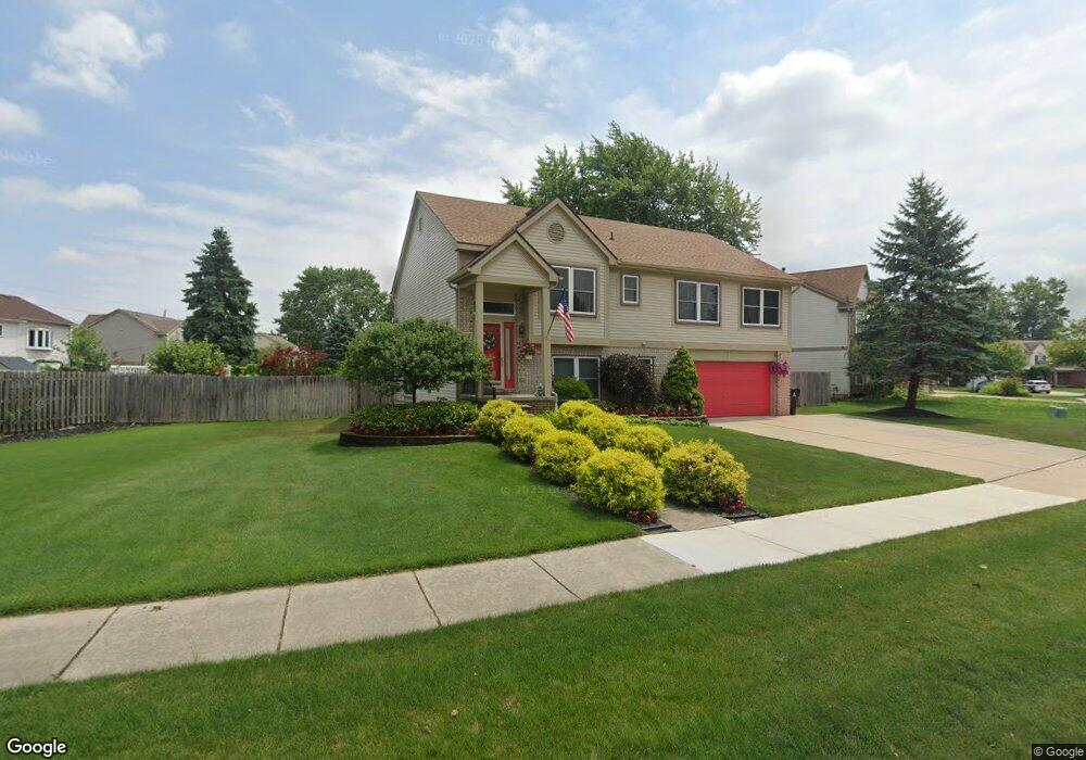
145 Stephanie Dr Westland, MI 48186
Estimated Value: $350,578 - $389,000
3
Beds
3
Baths
2,227
Sq Ft
$164/Sq Ft
Est. Value
About This Home
This home is located at 145 Stephanie Dr, Westland, MI 48186 and is currently estimated at $364,645, approximately $163 per square foot. 145 Stephanie Dr is a home located in Wayne County with nearby schools including Wildwood Elementary School, Marshall Upper Elementary School, and Adlai Stevenson Middle School.
Ownership History
Date
Name
Owned For
Owner Type
Purchase Details
Closed on
Jul 22, 2005
Sold by
Bargerstock Douglas M and Bargerstock Judy
Bought by
Bargerstock Douglas M
Current Estimated Value
Home Financials for this Owner
Home Financials are based on the most recent Mortgage that was taken out on this home.
Original Mortgage
$208,000
Outstanding Balance
$110,048
Interest Rate
5.87%
Mortgage Type
New Conventional
Estimated Equity
$254,597
Purchase Details
Closed on
Apr 22, 2003
Sold by
Mcfarland Alfred L and Eaton Yuvelle
Bought by
Bargerstock Douglas M
Create a Home Valuation Report for This Property
The Home Valuation Report is an in-depth analysis detailing your home's value as well as a comparison with similar homes in the area
Home Values in the Area
Average Home Value in this Area
Purchase History
| Date | Buyer | Sale Price | Title Company |
|---|---|---|---|
| Bargerstock Douglas M | -- | Pioneer Title Services | |
| Bargerstock Douglas M | $245,100 | Multiple |
Source: Public Records
Mortgage History
| Date | Status | Borrower | Loan Amount |
|---|---|---|---|
| Open | Bargerstock Douglas M | $208,000 |
Source: Public Records
Tax History Compared to Growth
Tax History
| Year | Tax Paid | Tax Assessment Tax Assessment Total Assessment is a certain percentage of the fair market value that is determined by local assessors to be the total taxable value of land and additions on the property. | Land | Improvement |
|---|---|---|---|---|
| 2025 | $4,245 | $159,200 | $0 | $0 |
| 2024 | $4,245 | $147,200 | $0 | $0 |
| 2023 | $4,054 | $138,300 | $0 | $0 |
| 2022 | $4,659 | $126,500 | $0 | $0 |
| 2021 | $4,542 | $117,600 | $0 | $0 |
| 2020 | $4,494 | $121,100 | $0 | $0 |
| 2019 | $4,330 | $117,600 | $0 | $0 |
| 2018 | $3,335 | $106,800 | $0 | $0 |
| 2017 | $1,468 | $105,200 | $0 | $0 |
| 2016 | $4,203 | $101,800 | $0 | $0 |
| 2015 | $8,255 | $82,550 | $0 | $0 |
| 2013 | $8,158 | $85,470 | $0 | $0 |
| 2012 | $3,512 | $81,650 | $0 | $0 |
Source: Public Records
Map
Nearby Homes
- 540 Dartmouth Crescent Ct
- 36034 Rolf St
- 788 N Linville St
- 624 N Parent St
- 36323 Monroe Ave
- 639 N Harvey St
- 36293 Monroe Ave
- 36020 Glen St
- 977 N Newburgh Rd
- 35720 Glen St
- 36231 Hazelwood St
- 37575 Barkridge Cir Unit 54
- 1519 S Dowling St
- 35228 Rosslyn St
- 35052 Cherry Hill Rd
- 404 N Sybald St
- 1510 S Crown St
- 35193 Sansburn St
- 344 S Christine
- 35236 Glen St
- 157 Stephanie Dr
- 36655 Cherry Hill Rd
- 36641 Cherry Hill Rd
- 36629 Cherry Hill Rd
- 169 Stephanie Dr
- 36673 Cherry Oak Dr
- 124 Stephanie Dr
- 136 Stephanie Dr
- 36617 Cherry Hill Rd
- 36777 Cherry Hill Rd
- 36685 Cherry Oak Dr
- 36605 Cherry Hill Rd
- 181 Stephanie Dr
- 184 Stephanie Dr
- 36690 Cherry Oak Dr
- 36697 Cherry Oak Dr
- 193 Stephanie Dr
- 158 S Carlson St
- 146 S Carlson St
- 146 S Carlson St