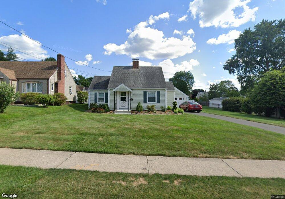
145 Stoddard Ave Newington, CT 06111
Estimated Value: $285,000 - $354,000
2
Beds
1
Bath
911
Sq Ft
$335/Sq Ft
Est. Value
About This Home
This home is located at 145 Stoddard Ave, Newington, CT 06111 and is currently estimated at $305,554, approximately $335 per square foot. 145 Stoddard Ave is a home located in Hartford County with nearby schools including Anna Reynolds School, Martin Kellogg Middle School, and Newington High School.
Ownership History
Date
Name
Owned For
Owner Type
Purchase Details
Closed on
Jul 31, 1996
Sold by
Escribano Eduardo and Escribano Kimberly
Bought by
Gionfriddo Donna
Current Estimated Value
Purchase Details
Closed on
Jun 15, 1992
Sold by
Lojko Jeffrey and Barents Wendy
Bought by
Escribano Eduardo and Escribano Kimberly
Purchase Details
Closed on
Sep 1, 1989
Sold by
Fleming Walter J
Bought by
Lojko Jeffrey J
Purchase Details
Closed on
Jul 7, 1988
Sold by
Kron S S
Bought by
Rostowky Richard
Purchase Details
Closed on
Jul 20, 1987
Sold by
Dalidowitz Paul J
Bought by
Fleming Walter J
Create a Home Valuation Report for This Property
The Home Valuation Report is an in-depth analysis detailing your home's value as well as a comparison with similar homes in the area
Home Values in the Area
Average Home Value in this Area
Purchase History
| Date | Buyer | Sale Price | Title Company |
|---|---|---|---|
| Gionfriddo Donna | $120,000 | -- | |
| Escribano Eduardo | $124,000 | -- | |
| Lojko Jeffrey J | $158,000 | -- | |
| Rostowky Richard | $349,900 | -- | |
| Fleming Walter J | $145,000 | -- |
Source: Public Records
Mortgage History
| Date | Status | Borrower | Loan Amount |
|---|---|---|---|
| Open | Fleming Walter J | $35,000 | |
| Open | Fleming Walter J | $110,000 |
Source: Public Records
Tax History Compared to Growth
Tax History
| Year | Tax Paid | Tax Assessment Tax Assessment Total Assessment is a certain percentage of the fair market value that is determined by local assessors to be the total taxable value of land and additions on the property. | Land | Improvement |
|---|---|---|---|---|
| 2025 | $4,561 | $114,090 | $57,680 | $56,410 |
| 2024 | $4,526 | $114,090 | $57,680 | $56,410 |
| 2023 | $4,376 | $114,090 | $57,680 | $56,410 |
| 2022 | $4,391 | $114,090 | $57,680 | $56,410 |
| 2021 | $4,428 | $114,090 | $57,680 | $56,410 |
| 2020 | $4,240 | $107,950 | $54,070 | $53,880 |
| 2019 | $4,259 | $107,950 | $54,070 | $53,880 |
| 2018 | $4,156 | $107,950 | $54,070 | $53,880 |
| 2017 | $3,950 | $107,950 | $54,070 | $53,880 |
| 2016 | $3,859 | $107,950 | $54,070 | $53,880 |
| 2014 | $3,687 | $106,040 | $53,800 | $52,240 |
Source: Public Records
Map
Nearby Homes
- 140 Camp Ave
- 35 Harding Ave
- 27 Harding Ave
- 47 Francis Dr
- 105 Gilbert Rd
- 31 Dacosta Dr
- 20 Surrey Dr Unit B16 aka B4
- 131 Williamstown Ct Unit 131
- 263 Williamstown Ct
- 305 Hampton Ct
- 29 Sunnyside Rd
- 37 Commonwealth Ave
- 84 Connecticut Ave
- 57 Welles Dr
- 559 Mountain Rd
- 16 Thornton Dr
- 228 Reservoir Rd
- 236 Sterling Dr Unit 236
- 218 Sterling Dr Unit 218
- 123 Ellsworth St
- 141 Stoddard Ave
- 153 Stoddard Ave
- 135 Stoddard Ave
- 157 Stoddard Ave
- 144 Camp Ave
- 148 Camp Ave
- 152 Camp Ave
- 131 Stoddard Ave
- 156 Camp Ave
- 146 Stoddard Ave
- 165 Stoddard Ave
- 152 Stoddard Ave
- 134 Camp Ave
- 160 Camp Ave
- 158 Stoddard Ave
- 125 Stoddard Ave
- 128 Camp Ave
- 132 Stoddard Ave
- 164 Camp Ave
- 168 Stoddard Ave