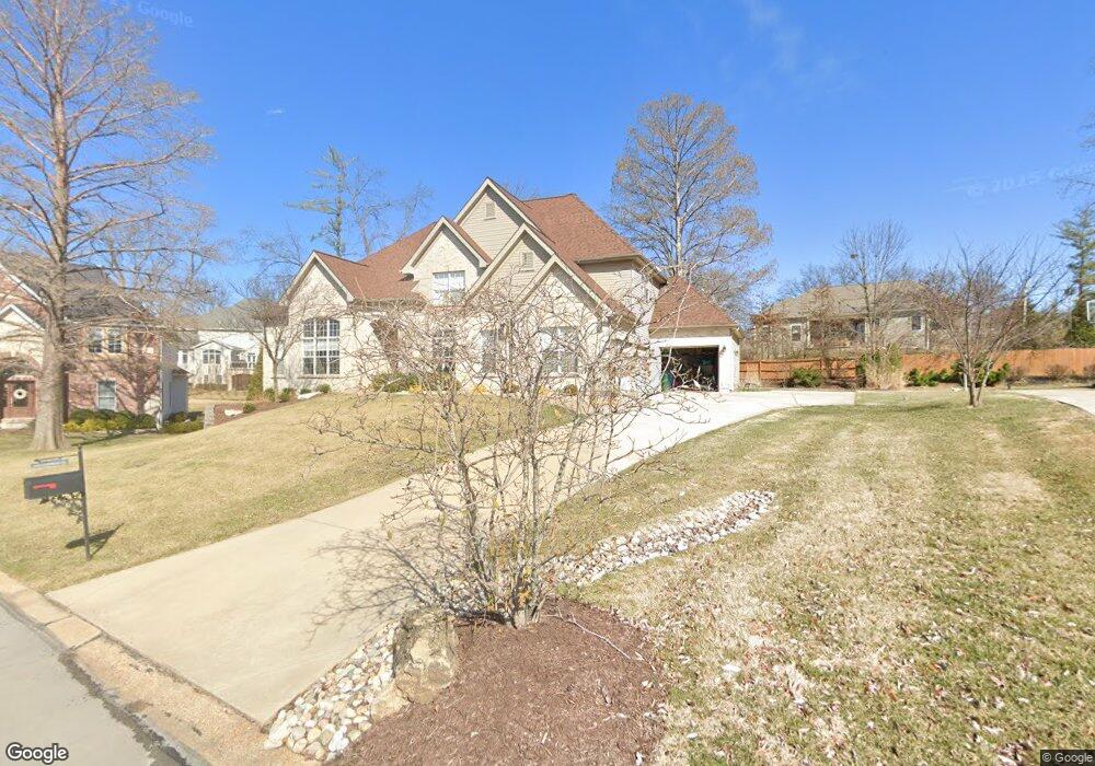
1450 Fairbrook Dr Saint Louis, MO 63131
Estimated Value: $1,405,177 - $1,741,000
5
Beds
5
Baths
5,510
Sq Ft
$284/Sq Ft
Est. Value
About This Home
This home is located at 1450 Fairbrook Dr, Saint Louis, MO 63131 and is currently estimated at $1,564,794, approximately $283 per square foot. 1450 Fairbrook Dr is a home located in St. Louis County with nearby schools including Westchester Elementary School, North Kirkwood Middle School, and Kirkwood Senior High School.
Ownership History
Date
Name
Owned For
Owner Type
Purchase Details
Closed on
Aug 12, 2010
Sold by
The Revocable Indenture Of Trust Of Sall
Bought by
Mccarthy Robert and Mccarthy Marilyn
Current Estimated Value
Home Financials for this Owner
Home Financials are based on the most recent Mortgage that was taken out on this home.
Original Mortgage
$417,000
Outstanding Balance
$271,333
Interest Rate
4.54%
Mortgage Type
New Conventional
Estimated Equity
$1,293,461
Purchase Details
Closed on
Nov 24, 2009
Sold by
Beal Family Trust
Bought by
The Revocable Indenture Of Trust Of Sall
Home Financials for this Owner
Home Financials are based on the most recent Mortgage that was taken out on this home.
Original Mortgage
$157,500
Interest Rate
4.99%
Mortgage Type
Future Advance Clause Open End Mortgage
Create a Home Valuation Report for This Property
The Home Valuation Report is an in-depth analysis detailing your home's value as well as a comparison with similar homes in the area
Home Values in the Area
Average Home Value in this Area
Purchase History
| Date | Buyer | Sale Price | Title Company |
|---|---|---|---|
| Mccarthy Robert | $858,980 | None Available | |
| The Revocable Indenture Of Trust Of Sall | -- | None Available |
Source: Public Records
Mortgage History
| Date | Status | Borrower | Loan Amount |
|---|---|---|---|
| Open | Mccarthy Robert | $417,000 | |
| Previous Owner | The Revocable Indenture Of Trust Of Sall | $157,500 |
Source: Public Records
Tax History
| Year | Tax Paid | Tax Assessment Tax Assessment Total Assessment is a certain percentage of the fair market value that is determined by local assessors to be the total taxable value of land and additions on the property. | Land | Improvement |
|---|---|---|---|---|
| 2025 | $12,270 | $244,060 | $65,040 | $179,020 |
| 2024 | $12,270 | $212,590 | $45,030 | $167,560 |
| 2023 | $12,080 | $212,590 | $45,030 | $167,560 |
| 2022 | $10,914 | $179,000 | $45,030 | $133,970 |
| 2021 | $10,796 | $179,000 | $45,030 | $133,970 |
| 2020 | $10,791 | $172,020 | $41,570 | $130,450 |
| 2019 | $10,805 | $172,020 | $41,570 | $130,450 |
| 2018 | $10,548 | $150,670 | $26,010 | $124,660 |
| 2017 | $10,576 | $150,670 | $26,010 | $124,660 |
| 2016 | $10,164 | $146,660 | $22,290 | $124,370 |
Source: Public Records
Map
Nearby Homes
- 1319 Kendon Dr
- 1534 Woodgate Dr
- 1126 Bopp Rd
- 1209 Missouri Ave
- 1144 Missouri Ave
- 1741 Pine Hill Dr
- 701 Laurel Oak
- 1056 Cedargate Dr
- 11344 Manchester Rd
- 989 Des Peres Dr
- 11909 Lillian Ave
- 954 Rochdale Dr
- 2046 Willow Leaf Dr
- 1223 Simmons Ave
- 516 Kirkshire Dr
- 966 N Geyer Rd
- 613 Jasmin Dr
- 1025 Barry Ct
- 12224 TBB Roger Ln
- 12439 Springdale Ln Unit TBB
- 1442 Fairbrook Dr
- 11701 Lindemere Dr
- 1455 Breezeridge Dr
- 11616 Serama Dr
- 11626 Serama Dr
- 1449 Fairbrook Dr
- 11634 Serama Dr
- 1447 Breezeridge Dr
- 11705 Lindemere Dr
- 1434 Fairbrook Dr
- 11700 Serama Dr
- 1441 Fairbrook Dr
- 1441 Fairbrook-Tbb
- 11710 Serama Dr
- 1439 Breezeridge Dr
- 11710 Lindemere Dr
- 11717 Lindemere Dr
- 11718 Serama Dr
- 1426 Fairbrook Dr
- 1433 Fairbrook Dr
Your Personal Tour Guide
Ask me questions while you tour the home.