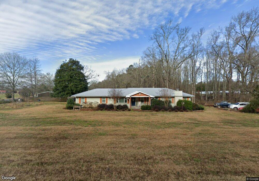
1451 Dials Mill Rd Statham, GA 30666
Estimated Value: $376,000 - $570,000
5
Beds
3
Baths
2,166
Sq Ft
$212/Sq Ft
Est. Value
About This Home
This home is located at 1451 Dials Mill Rd, Statham, GA 30666 and is currently estimated at $460,031, approximately $212 per square foot. 1451 Dials Mill Rd is a home located in Oconee County with nearby schools including Rocky Branch Elementary School, Malcom Bridge Middle School, and North Oconee High School.
Ownership History
Date
Name
Owned For
Owner Type
Purchase Details
Closed on
Apr 16, 2007
Sold by
Not Provided
Bought by
Ross William Crane and Bethany Lee Ross
Current Estimated Value
Home Financials for this Owner
Home Financials are based on the most recent Mortgage that was taken out on this home.
Original Mortgage
$124,000
Outstanding Balance
$74,767
Interest Rate
6.1%
Mortgage Type
New Conventional
Estimated Equity
$385,264
Purchase Details
Closed on
Nov 30, 2005
Sold by
Harlan Greg A
Bought by
B & D Land Llc
Purchase Details
Closed on
Oct 4, 1996
Bought by
Johnson Phillip K
Create a Home Valuation Report for This Property
The Home Valuation Report is an in-depth analysis detailing your home's value as well as a comparison with similar homes in the area
Home Values in the Area
Average Home Value in this Area
Purchase History
| Date | Buyer | Sale Price | Title Company |
|---|---|---|---|
| Ross William Crane | $155,000 | -- | |
| B & D Land Llc | $246,000 | -- | |
| Johnson Phillip K | $83,000 | -- |
Source: Public Records
Mortgage History
| Date | Status | Borrower | Loan Amount |
|---|---|---|---|
| Open | Ross William Crane | $124,000 | |
| Closed | Ross William Crane | $15,500 |
Source: Public Records
Tax History Compared to Growth
Tax History
| Year | Tax Paid | Tax Assessment Tax Assessment Total Assessment is a certain percentage of the fair market value that is determined by local assessors to be the total taxable value of land and additions on the property. | Land | Improvement |
|---|---|---|---|---|
| 2024 | $2,039 | $111,149 | $32,069 | $79,080 |
| 2023 | $2,039 | $103,004 | $29,694 | $73,310 |
| 2022 | $1,842 | $87,860 | $23,756 | $64,104 |
| 2021 | $1,793 | $79,447 | $21,596 | $57,851 |
| 2020 | $1,648 | $73,087 | $19,632 | $53,455 |
| 2019 | $1,574 | $69,894 | $17,072 | $52,822 |
| 2018 | $1,414 | $61,687 | $15,520 | $46,167 |
| 2017 | $1,263 | $55,324 | $12,933 | $42,391 |
| 2016 | $1,206 | $52,913 | $11,758 | $41,155 |
| 2015 | $1,204 | $52,703 | $11,758 | $40,946 |
| 2014 | $1,169 | $50,134 | $10,689 | $39,445 |
| 2013 | -- | $47,968 | $10,609 | $37,359 |
Source: Public Records
Map
Nearby Homes
- 1181 Pete Dickens Rd
- 1190 Cobblestone Ln
- 4100 Monroe Hwy
- 4400 Monroe Hwy Unit PARCEL 1-7
- 2986 Coralbell Dr
- 1250 Pete Dickens Rd
- 1472 Lily Ln
- 3240 Monroe Hwy
- 1145 Summerfield Ln
- 1180 Summerfield Ln
- 1931 Blazing Star Ct
- 2510 Blazing Star Ct
- 2779 Blazing Star Ct
- 1120 Liberty Ln
- 1003 Beebalm Dr
- 1060 Fox Hollow Ct
- 1220 Day Dr
- 1520 Dials Mill Rd
- 1540 Dials Mill Rd
- 1501 Dials Mill Rd
- 1550 Dials Mill Rd
- 1371 Dials Mill Rd
- 1591 Dials Mill Rd
- 1050 Diamond Way Unit 19B
- 1060 Diamond Way Unit 16B
- 1060 Diamond Way
- 1070 Diamond Way Unit 15B
- 1070 Diamond Way
- 1030 Diamond Way Unit 17B
- 1030 Diamond Way Unit 20B
- 1030 Diamond Way
- 0 Jade St Unit 7470855
- 0 Jade St Unit 3093634
- 0 Jade St Unit 43 8827079
- 0 Jade St
- 1010 Diamond Way Unit 18
- 1010 Diamond Way