Estimated Value: $188,000 - $282,000
5
Beds
4
Baths
2,883
Sq Ft
$83/Sq Ft
Est. Value
About This Home
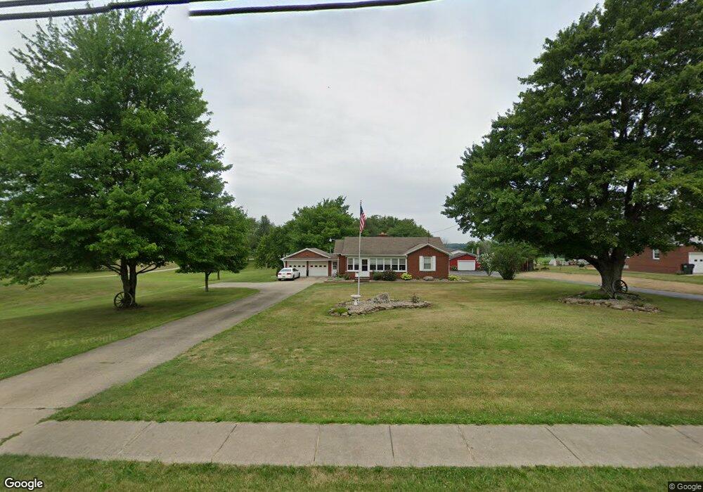
This home is located at 14526 State Route 534, Salem, OH 44460 and is currently estimated at $239,296, approximately $83 per square foot. 14526 State Route 534 is a home located in Mahoning County with nearby schools including West Branch Middle School and West Branch High School.
Ownership History
Date
Name
Owned For
Owner Type
Purchase Details
Closed on
Aug 24, 2009
Sold by
Wilmoth Timmy B and Wilmoth Sandra K
Bought by
Wilmoth Timmy B and Wilmoth Sandra K
Current Estimated Value
Purchase Details
Closed on
Aug 21, 2009
Sold by
Phillips Roger L and Phillips Rebecca M
Bought by
Wilmoth Timmy B and Wilmoth Sandra K
Purchase Details
Closed on
Mar 23, 1988
Bought by
Wilmoth Timmy B
Create a Home Valuation Report for This Property
The Home Valuation Report is an in-depth analysis detailing your home's value as well as a comparison with similar homes in the area
Purchase History
| Date | Buyer | Sale Price | Title Company |
|---|---|---|---|
| Wilmoth Timmy B | -- | Attorney | |
| Wilmoth Timmy B | $9,700 | Attorney | |
| Wilmoth Timmy B | -- | -- |
Source: Public Records
Tax History
| Year | Tax Paid | Tax Assessment Tax Assessment Total Assessment is a certain percentage of the fair market value that is determined by local assessors to be the total taxable value of land and additions on the property. | Land | Improvement |
|---|---|---|---|---|
| 2025 | $3,380 | $80,980 | $12,800 | $68,180 |
| 2024 | $3,142 | $80,980 | $12,800 | $68,180 |
| 2023 | $3,107 | $80,980 | $12,800 | $68,180 |
| 2022 | $2,658 | $60,670 | $11,940 | $48,730 |
| 2021 | $2,582 | $60,670 | $11,940 | $48,730 |
| 2020 | $2,592 | $60,670 | $11,940 | $48,730 |
| 2019 | $2,414 | $52,890 | $11,940 | $40,950 |
| 2018 | $2,404 | $52,890 | $11,940 | $40,950 |
| 2017 | $2,381 | $52,890 | $11,940 | $40,950 |
| 2016 | $2,392 | $53,140 | $12,890 | $40,250 |
| 2015 | $2,326 | $53,140 | $12,890 | $40,250 |
| 2014 | $2,337 | $53,140 | $12,890 | $40,250 |
| 2013 | $2,329 | $53,140 | $12,890 | $40,250 |
Source: Public Records
Map
Nearby Homes
- 14831 Smith Goshen Rd
- 14965 Seacrist Rd
- 14980 Salem Alliance Rd
- 30263 St Rt 62
- 17325 5th St
- 28196 Hartley Rd
- 35 Bayview Dr
- 18061 Derr Ave
- 1497 Lake Front Dr
- 18280 5th St
- 1511 Lake Front Dr
- 15938 W South Range Rd
- 26223 Wildwood Dr
- 29655 Buck Rd
- 18262 W Pine Lake Rd
- 27696 Buck Rd
- 18 Boxwood Dr
- 11 Redwood St
- 57 Redwood St
- 73 Redwood St
- 14492 State Route 534
- 14470 Pricetown Rd
- 14473 Danbury Dr
- 14615 State Route 534
- 14561 S Pricetown Rd
- 14564 S Pricetown Rd
- 14638 S Pricetown Rd
- 14638 S Pricetown Rd
- 14638 State Route 534
- 14690 S Pricetown Rd
- 14656 S Pricetown Rd
- 14656 S Pricetown Rd
- 14645 S Pricetown Rd
- 14674 S Pricetown Rd
- 14673 S Pricetown Rd
- 15915 Danbury Dr
- 0 5th St Unit 4331097
- 0 5th St Unit 4151055
- 14693 S Pricetown Rd
- 15882 Danbury Dr
Your Personal Tour Guide
Ask me questions while you tour the home.