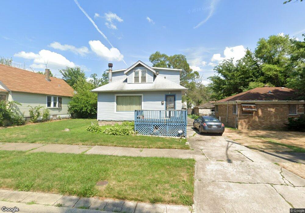
14533 Union Ave Harvey, IL 60426
Estimated Value: $127,000 - $179,000
4
Beds
3
Baths
1,914
Sq Ft
$80/Sq Ft
Est. Value
About This Home
This home is located at 14533 Union Ave, Harvey, IL 60426 and is currently estimated at $153,134, approximately $80 per square foot. 14533 Union Ave is a home located in Cook County with nearby schools including Bryant Elementary School, Brooks Middle School, and Thornton Township High School.
Ownership History
Date
Name
Owned For
Owner Type
Purchase Details
Closed on
Mar 19, 1996
Sold by
Thomas Kevin
Bought by
Wilson Judy
Current Estimated Value
Home Financials for this Owner
Home Financials are based on the most recent Mortgage that was taken out on this home.
Original Mortgage
$68,967
Outstanding Balance
$2,567
Interest Rate
6.5%
Mortgage Type
FHA
Estimated Equity
$150,567
Create a Home Valuation Report for This Property
The Home Valuation Report is an in-depth analysis detailing your home's value as well as a comparison with similar homes in the area
Home Values in the Area
Average Home Value in this Area
Purchase History
| Date | Buyer | Sale Price | Title Company |
|---|---|---|---|
| Wilson Judy | $70,000 | -- |
Source: Public Records
Mortgage History
| Date | Status | Borrower | Loan Amount |
|---|---|---|---|
| Open | Wilson Judy | $68,967 |
Source: Public Records
Tax History Compared to Growth
Tax History
| Year | Tax Paid | Tax Assessment Tax Assessment Total Assessment is a certain percentage of the fair market value that is determined by local assessors to be the total taxable value of land and additions on the property. | Land | Improvement |
|---|---|---|---|---|
| 2024 | $2,635 | $10,000 | $2,144 | $7,856 |
| 2023 | $144 | $10,000 | $2,144 | $7,856 |
| 2022 | $144 | $7,020 | $1,838 | $5,182 |
| 2021 | $804 | $7,018 | $1,837 | $5,181 |
| 2020 | $1,157 | $7,018 | $1,837 | $5,181 |
| 2019 | $987 | $7,445 | $1,684 | $5,761 |
| 2018 | $5,638 | $7,445 | $1,684 | $5,761 |
| 2017 | $514 | $7,445 | $1,684 | $5,761 |
| 2016 | $2,298 | $8,226 | $1,531 | $6,695 |
| 2015 | $3,483 | $8,226 | $1,531 | $6,695 |
| 2014 | $3,508 | $8,226 | $1,531 | $6,695 |
| 2013 | $4,039 | $9,270 | $1,531 | $7,739 |
Source: Public Records
Map
Nearby Homes
- 14508 Des Plaines St
- 14601 Des Plaines St
- 14455 Des Plaines St
- 14443 Des Plaines St
- 380 Calumet Blvd
- 14452 Green St
- 306 Calumet Blvd
- 345 Calumet Blvd
- 320 Streamside Dr
- 360 Streamside Dr
- 14637 Vincennes Rd
- 14631 Vincennes Rd
- 14542 Sangamon St
- 14622 Vincennes Rd
- 296 E 148th St
- 309 Streamside Dr
- 14803 Madison Ave
- 14301 S Halsted St
- 14359 Park Ave
- 14637 Center Ave
- 14527 Union Ave
- 14535 Union Ave
- 14523 Union Ave
- 14530 Des Plaines St
- 14530 Des Plaines St
- 14528 Des Plaines St
- 14536 Des Plaines St
- 14522 Des Plaines St
- 14530 Union Ave
- 14540 Des Plaines St
- 14540 Des Plaines St
- 14528 Union Ave
- 14534 Union Ave
- 14534 Union Ave
- 14520 Des Plaines St
- 14524 Union Ave
- 14538 Union Ave
- 14518 Des Plaines St
- 14542 Union Ave
- 14516 Des Plaines St