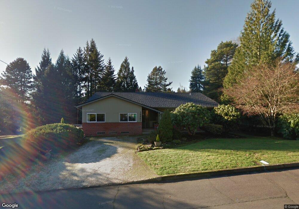
14561 Doris Ave Lake Oswego, OR 97035
Uplands NeighborhoodEstimated Value: $902,756 - $1,683,000
3
Beds
3
Baths
3,543
Sq Ft
$327/Sq Ft
Est. Value
About This Home
This home is located at 14561 Doris Ave, Lake Oswego, OR 97035 and is currently estimated at $1,159,189, approximately $327 per square foot. 14561 Doris Ave is a home located in Clackamas County with nearby schools including Forest Hills Elementary School, Lake Oswego Junior High School, and Lake Oswego Senior High School.
Ownership History
Date
Name
Owned For
Owner Type
Purchase Details
Closed on
Apr 10, 2009
Sold by
Mount Tenny Myron and Mount Lindy
Bought by
Mount Lindy
Current Estimated Value
Purchase Details
Closed on
Aug 8, 2008
Sold by
Mount Lindy and Mount Tenny Myron
Bought by
Mount Lindy
Purchase Details
Closed on
Sep 25, 1997
Sold by
Mount Lindy Joi
Bought by
Mount Paul E and Mount Ruth A
Purchase Details
Closed on
Jul 23, 1997
Sold by
Mount Paul E and Mount Ruth A
Bought by
Mount Paul E and Mount Ruth A
Create a Home Valuation Report for This Property
The Home Valuation Report is an in-depth analysis detailing your home's value as well as a comparison with similar homes in the area
Home Values in the Area
Average Home Value in this Area
Purchase History
| Date | Buyer | Sale Price | Title Company |
|---|---|---|---|
| Mount Lindy | -- | Accommodation | |
| Mount Lindy | -- | Accommodation | |
| Mount Lindy | -- | None Available | |
| Mount Paul E | -- | Transnation Title Insurance | |
| Mount Paul E | -- | -- |
Source: Public Records
Tax History Compared to Growth
Tax History
| Year | Tax Paid | Tax Assessment Tax Assessment Total Assessment is a certain percentage of the fair market value that is determined by local assessors to be the total taxable value of land and additions on the property. | Land | Improvement |
|---|---|---|---|---|
| 2025 | $6,836 | $355,962 | -- | -- |
| 2024 | $6,654 | $345,595 | -- | -- |
| 2023 | $6,654 | $335,530 | $0 | $0 |
| 2022 | $6,267 | $325,758 | $0 | $0 |
| 2021 | $5,788 | $316,270 | $0 | $0 |
| 2020 | $5,643 | $307,059 | $0 | $0 |
| 2019 | $5,504 | $298,116 | $0 | $0 |
| 2018 | $5,234 | $289,433 | $0 | $0 |
| 2017 | $5,050 | $281,003 | $0 | $0 |
| 2016 | $4,598 | $272,818 | $0 | $0 |
| 2015 | $4,442 | $264,872 | $0 | $0 |
| 2014 | $4,385 | $257,157 | $0 | $0 |
Source: Public Records
Map
Nearby Homes
- 2 Falstaff St
- 6 Falstaff St
- 50 Touchstone
- 15003 Twin Fir Rd
- 2703 Glen Eagles Rd
- 16 Othello St
- 2560 Glen Eagles Place
- 15370 Twin Fir Rd
- 14417 Orchard Springs Rd
- 3676 Spring Ln
- 10 Mountain Cir
- 2406 Glen Eagles Rd
- 3853 Carman Dr
- 2217 Prestwick Rd
- 90 Wheatherstone Place
- 2157 Wembley Place
- 4 Touchstone Unit 136
- 4 Touchstone Unit 132
- 4 Touchstone Unit 138
- 4 Touchstone Unit 141
- 14599 Doris Ave
- 14491 Doris Ave
- 14542 Rainbow Dr
- 14536 Rainbow Dr
- 14520 Rainbow Dr
- 14584 Doris Ave
- 14550 Doris Ave
- 14611 Doris Ave
- 14461 Doris Ave
- 14584 Rainbow Dr
- 14636 Doris Ave
- 14480 Doris Ave
- 14664 Rainbow Dr
- 14669 Doris Ave
- 14433 Doris Ave
- 14527 Rainbow Dr
- 14666 Doris Ave
- 3122 Diane Dr
- 14444 Doris Ave
- 14627 Rainbow Dr