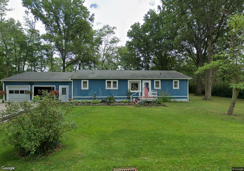
14595 Ardmore Dr NE Alliance, OH 44601
Estimated Value: $153,000 - $190,000
3
Beds
2
Baths
1,400
Sq Ft
$122/Sq Ft
Est. Value
About This Home
This home is located at 14595 Ardmore Dr NE, Alliance, OH 44601 and is currently estimated at $170,386, approximately $121 per square foot. 14595 Ardmore Dr NE is a home located in Stark County with nearby schools including Marlington High School and Regina Coeli/St Joseph School.
Ownership History
Date
Name
Owned For
Owner Type
Purchase Details
Closed on
Jun 22, 1999
Sold by
Foley Randy L
Bought by
Foley Randy L and Foley Pamela
Current Estimated Value
Home Financials for this Owner
Home Financials are based on the most recent Mortgage that was taken out on this home.
Original Mortgage
$73,500
Interest Rate
7.15%
Mortgage Type
Purchase Money Mortgage
Create a Home Valuation Report for This Property
The Home Valuation Report is an in-depth analysis detailing your home's value as well as a comparison with similar homes in the area
Home Values in the Area
Average Home Value in this Area
Purchase History
| Date | Buyer | Sale Price | Title Company |
|---|---|---|---|
| Foley Randy L | -- | Reliable Title Services |
Source: Public Records
Mortgage History
| Date | Status | Borrower | Loan Amount |
|---|---|---|---|
| Closed | Foley Randy L | $73,500 |
Source: Public Records
Tax History Compared to Growth
Tax History
| Year | Tax Paid | Tax Assessment Tax Assessment Total Assessment is a certain percentage of the fair market value that is determined by local assessors to be the total taxable value of land and additions on the property. | Land | Improvement |
|---|---|---|---|---|
| 2025 | -- | $47,080 | $15,160 | $31,920 |
| 2024 | -- | $47,080 | $15,160 | $31,920 |
| 2023 | $1,329 | $37,740 | $5,640 | $32,100 |
| 2022 | $1,334 | $37,740 | $5,640 | $32,100 |
| 2021 | $1,338 | $37,740 | $5,640 | $32,100 |
| 2020 | $1,305 | $32,800 | $4,870 | $27,930 |
| 2019 | $1,296 | $32,800 | $4,870 | $27,930 |
| 2018 | $1,298 | $32,800 | $4,870 | $27,930 |
| 2017 | $1,435 | $33,950 | $2,590 | $31,360 |
| 2016 | $1,435 | $33,950 | $2,590 | $31,360 |
| 2015 | $1,597 | $39,660 | $2,590 | $37,070 |
| 2014 | $1,507 | $34,200 | $2,240 | $31,960 |
| 2013 | $750 | $34,200 | $2,240 | $31,960 |
Source: Public Records
Map
Nearby Homes
- 14422 Sturbridge Rd NE
- 14723 Bolton St NE
- 0 Johnson Ave NE Unit 5142926
- 0 Homestead Ave NE
- 0 Klinger Ave NE
- 0 Meadowbrook Ave
- 000 Klinger Ave
- 11480 Aebi Ave NE
- 15520 Coalbank St NE
- 11344 Walnut Ave NE
- 432 Johnson Ave
- 0 Knoll St NE
- 511 W Ely St
- 13109 Edison St NE
- 15832 Waverly St NE
- 124 E Wayne St
- 15995 Elbrook St NE
- 15789 Coalbank St NE
- 505 N Union Ave
- 11310 Webb Ave NE
- 14584 Ardmore Dr NE
- 14621 Ardmore Dr NE
- 12034 Mercer Rd NE
- 14596 Ardmore Dr NE
- 12032 Mercer Rd NE
- 14633 Ardmore Dr NE
- 14573 Spruce Dr NE
- 12037 Mercer Rd NE
- 14585 Spruce Dr NE
- 11931 Northside Rd NE
- 11950 Northside Rd NE
- 11981 Iowa Ave NE
- 11991 Mercer Rd NE
- 14566 Spruce Dr NE
- 14550 Spruce Dr NE
- 14578 Spruce Dr NE
- 14633 Spruce Dr NE
- 14485 Spruce Dr NE
- 14494 Ardmore Dr NE
- 14487 Ardmore Dr NE