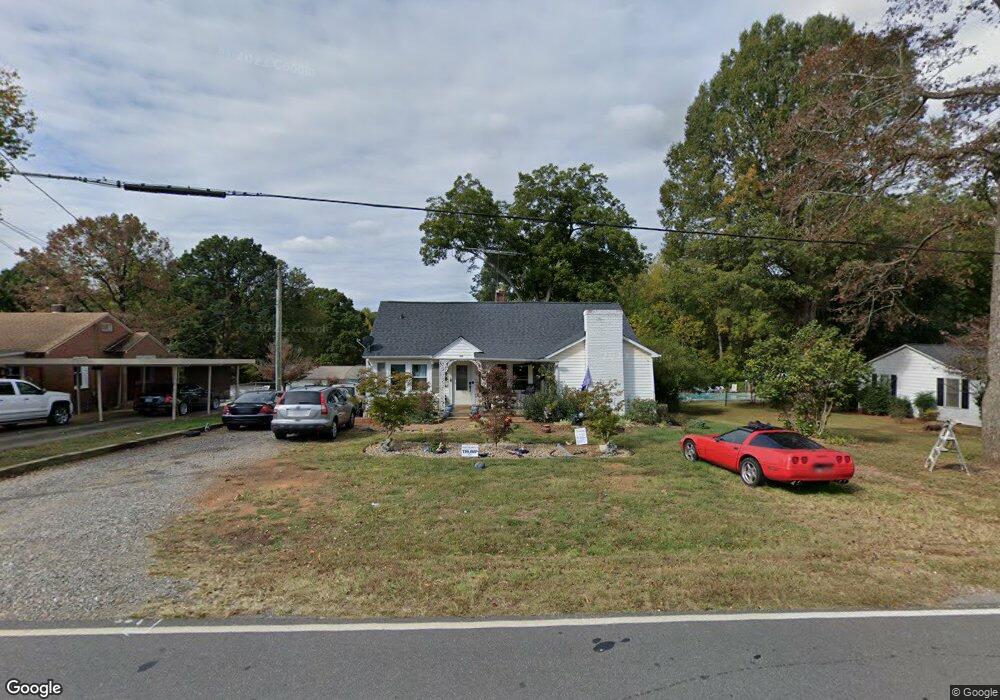
146 Airport Rd Statesville, NC 28677
Estimated Value: $140,000 - $203,409
3
Beds
2
Baths
1,556
Sq Ft
$119/Sq Ft
Est. Value
About This Home
This home is located at 146 Airport Rd, Statesville, NC 28677 and is currently estimated at $184,852, approximately $118 per square foot. 146 Airport Rd is a home located in Iredell County with nearby schools including Celeste Henkel Elementary School, West Iredell Middle School, and West Iredell High School.
Ownership History
Date
Name
Owned For
Owner Type
Purchase Details
Closed on
Apr 5, 2017
Sold by
Brewer Tony Lynn and Brewer Robin D
Bought by
Williams Malissa
Current Estimated Value
Home Financials for this Owner
Home Financials are based on the most recent Mortgage that was taken out on this home.
Original Mortgage
$77,000
Outstanding Balance
$52,695
Interest Rate
4.5%
Mortgage Type
Adjustable Rate Mortgage/ARM
Estimated Equity
$132,157
Purchase Details
Closed on
Feb 5, 2015
Sold by
Woods Gary D and Peacock Lynda W
Bought by
Brewer Tony Lynn
Purchase Details
Closed on
Apr 19, 1947
Bought by
Woods R J
Create a Home Valuation Report for This Property
The Home Valuation Report is an in-depth analysis detailing your home's value as well as a comparison with similar homes in the area
Home Values in the Area
Average Home Value in this Area
Purchase History
| Date | Buyer | Sale Price | Title Company |
|---|---|---|---|
| Williams Malissa | -- | None Available | |
| Williams Melissa | $75,000 | None Available | |
| Brewer Tony Lynn | $40,000 | None Available | |
| Woods R J | -- | -- |
Source: Public Records
Mortgage History
| Date | Status | Borrower | Loan Amount |
|---|---|---|---|
| Open | Williams Melissa | $77,000 |
Source: Public Records
Tax History Compared to Growth
Tax History
| Year | Tax Paid | Tax Assessment Tax Assessment Total Assessment is a certain percentage of the fair market value that is determined by local assessors to be the total taxable value of land and additions on the property. | Land | Improvement |
|---|---|---|---|---|
| 2024 | $632 | $96,940 | $13,420 | $83,520 |
| 2023 | $632 | $90,590 | $13,420 | $77,170 |
| 2022 | $527 | $74,410 | $13,420 | $60,990 |
| 2021 | $523 | $74,410 | $13,420 | $60,990 |
| 2020 | $523 | $74,410 | $13,420 | $60,990 |
| 2019 | $515 | $74,410 | $13,420 | $60,990 |
| 2018 | $456 | $67,650 | $13,420 | $54,230 |
| 2017 | $456 | $67,650 | $13,420 | $54,230 |
| 2016 | $456 | $67,650 | $13,420 | $54,230 |
| 2015 | $456 | $67,650 | $13,420 | $54,230 |
| 2014 | $454 | $72,370 | $13,420 | $58,950 |
Source: Public Records
Map
Nearby Homes
- 130 Aviation Dr
- 00 Jamie Dr Unit 6
- 3004 Newton Dr
- 116 Bent Twig Dr
- 908 Westminster Dr
- 178 Old Airport Rd
- 289 Mary Locke Way
- Robie Plan at Bristol Terrace
- Penwell Plan at Bristol Terrace
- Hayden Plan at Bristol Terrace
- 119 Mary Locke Way
- Cali Plan at Bristol Terrace
- Aria Plan at Bristol Terrace
- Darwin Plan at Bristol Terrace
- Hamilton Plan at Bristol Terrace
- 131 Mary Locke Way
- Galen Plan at Bristol Terrace
- Aisle Plan at Bristol Terrace
- 827 Flint Dr
- 818 Candy Dr
- 150 Airport Rd
- 140 Airport Rd
- 156 Airport Rd
- 136 Airport Rd
- 130 Airport Rd
- 162 Airport Rd
- 161 Airport Rd
- 124 Airport Rd
- 172 Airport Rd
- 123 Airport Rd
- 116 Airport Rd
- 117 Airport Rd
- 2519 Hickory Hwy
- 2523 Hickory Hwy Unit 2531
- 2517 Hickory Hwy
- 110 Airport Rd
- 2543 Hickory Hwy
- 4477 Hickory Hwy
- 34 Airport Rd
- 117 Winberry Ln