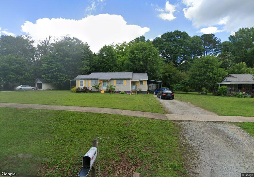
146 E Camp St Moreland, GA 30259
Estimated Value: $177,560 - $254,000
2
Beds
1
Bath
1,296
Sq Ft
$168/Sq Ft
Est. Value
About This Home
This home is located at 146 E Camp St, Moreland, GA 30259 and is currently estimated at $217,140, approximately $167 per square foot. 146 E Camp St is a home with nearby schools including Moreland Elementary School, Smokey Road Middle School, and Newnan High School.
Ownership History
Date
Name
Owned For
Owner Type
Purchase Details
Closed on
Nov 1, 2019
Sold by
Madaris Jackie W
Bought by
Lamey Aleyx
Current Estimated Value
Home Financials for this Owner
Home Financials are based on the most recent Mortgage that was taken out on this home.
Original Mortgage
$125,000
Outstanding Balance
$109,301
Interest Rate
3.65%
Estimated Equity
$107,839
Purchase Details
Closed on
Dec 29, 2006
Sold by
Gross Van
Bought by
Madaris Jackie W
Home Financials for this Owner
Home Financials are based on the most recent Mortgage that was taken out on this home.
Original Mortgage
$60,000
Interest Rate
6.1%
Mortgage Type
New Conventional
Purchase Details
Closed on
Dec 19, 2006
Sold by
Gross Gerrie
Bought by
Gross Van
Home Financials for this Owner
Home Financials are based on the most recent Mortgage that was taken out on this home.
Original Mortgage
$60,000
Interest Rate
6.1%
Mortgage Type
New Conventional
Purchase Details
Closed on
May 31, 1985
Bought by
Gross Van and Gross Gerrie
Create a Home Valuation Report for This Property
The Home Valuation Report is an in-depth analysis detailing your home's value as well as a comparison with similar homes in the area
Home Values in the Area
Average Home Value in this Area
Purchase History
| Date | Buyer | Sale Price | Title Company |
|---|---|---|---|
| Lamey Aleyx | $135,000 | -- | |
| Madaris Jackie W | $75,000 | -- | |
| Gross Van | -- | -- | |
| Gross Van | $30,000 | -- |
Source: Public Records
Mortgage History
| Date | Status | Borrower | Loan Amount |
|---|---|---|---|
| Open | Lamey Aleyx | $125,000 | |
| Previous Owner | Madaris Jackie W | $60,000 |
Source: Public Records
Tax History Compared to Growth
Tax History
| Year | Tax Paid | Tax Assessment Tax Assessment Total Assessment is a certain percentage of the fair market value that is determined by local assessors to be the total taxable value of land and additions on the property. | Land | Improvement |
|---|---|---|---|---|
| 2024 | $1,206 | $51,350 | $5,040 | $46,310 |
| 2023 | $1,206 | $39,272 | $5,040 | $34,232 |
| 2022 | $1,052 | $38,512 | $5,040 | $33,472 |
| 2021 | $1,007 | $33,957 | $5,040 | $28,917 |
| 2020 | $1,025 | $33,957 | $5,040 | $28,917 |
| 2019 | $719 | $21,373 | $5,594 | $15,779 |
| 2018 | $723 | $21,373 | $5,594 | $15,779 |
| 2017 | $723 | $21,373 | $5,594 | $15,779 |
| 2016 | $720 | $21,373 | $5,594 | $15,779 |
| 2015 | $708 | $21,373 | $5,594 | $15,779 |
| 2014 | $745 | $21,373 | $5,594 | $15,779 |
Source: Public Records
Map
Nearby Homes
- 145 E Camp St
- 8 Cameron St
- 61 Main St
- 15 Couch St
- 188 Ball St
- 33 Ball St
- 3486 S Highway 29
- 0 Teasley Trail Unit 10600969
- 114 Dingler Rd
- 0 Lamb Rd Unit 24477803
- 0 Lamb Rd Unit 10571369
- 1266 Martin Mill Rd
- 743 Alex Stephens Rd Unit LOT 6
- 779 Alex Stephens Rd Unit LOT 4
- 803 Alex Stephens Rd Unit LOT 3
- 885 Alex Stephens Rd Unit LOT 1
- 31 AC Lamb Rd
- 04 Bears Bend
- 2 Whites Pond Rd
- 84 Puckett Station Dr