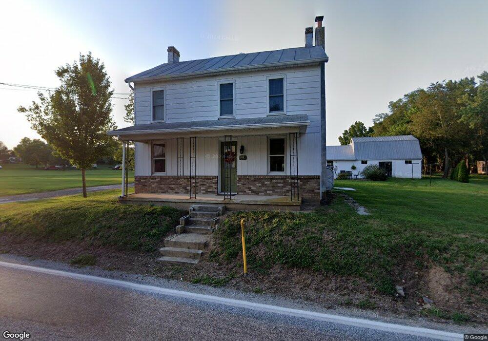
146 Georgetown Rd Littlestown, PA 17340
Estimated Value: $242,436 - $339,000
2
Beds
1
Bath
1,536
Sq Ft
$188/Sq Ft
Est. Value
About This Home
This home is located at 146 Georgetown Rd, Littlestown, PA 17340 and is currently estimated at $288,359, approximately $187 per square foot. 146 Georgetown Rd is a home with nearby schools including Rolling Acres El School, Maple Avenue Middle School, and Littlestown Senior High School.
Ownership History
Date
Name
Owned For
Owner Type
Purchase Details
Closed on
Nov 15, 2021
Sold by
Wetzel Diane E and Wetzel Jerry C
Bought by
Hale Diane E and Hale George A
Current Estimated Value
Home Financials for this Owner
Home Financials are based on the most recent Mortgage that was taken out on this home.
Original Mortgage
$55,000
Outstanding Balance
$50,398
Interest Rate
2.99%
Mortgage Type
New Conventional
Estimated Equity
$237,961
Purchase Details
Closed on
Oct 10, 1986
Bought by
Wetzel Diane E
Create a Home Valuation Report for This Property
The Home Valuation Report is an in-depth analysis detailing your home's value as well as a comparison with similar homes in the area
Home Values in the Area
Average Home Value in this Area
Purchase History
| Date | Buyer | Sale Price | Title Company |
|---|---|---|---|
| Hale Diane E | -- | None Available | |
| Wetzel Diane E | $45,000 | -- |
Source: Public Records
Mortgage History
| Date | Status | Borrower | Loan Amount |
|---|---|---|---|
| Open | Hale Diane E | $55,000 |
Source: Public Records
Tax History Compared to Growth
Tax History
| Year | Tax Paid | Tax Assessment Tax Assessment Total Assessment is a certain percentage of the fair market value that is determined by local assessors to be the total taxable value of land and additions on the property. | Land | Improvement |
|---|---|---|---|---|
| 2025 | $3,553 | $187,700 | $79,600 | $108,100 |
| 2024 | $3,415 | $187,700 | $79,600 | $108,100 |
| 2023 | $3,329 | $187,700 | $79,600 | $108,100 |
| 2022 | $3,305 | $187,700 | $79,600 | $108,100 |
| 2021 | $3,235 | $190,500 | $82,400 | $108,100 |
| 2020 | $3,188 | $190,500 | $82,400 | $108,100 |
| 2019 | $3,120 | $190,500 | $82,400 | $108,100 |
| 2018 | $3,027 | $190,500 | $82,400 | $108,100 |
| 2017 | $2,932 | $190,500 | $82,400 | $108,100 |
| 2016 | -- | $190,500 | $82,400 | $108,100 |
| 2015 | -- | $190,500 | $82,400 | $108,100 |
| 2014 | -- | $190,500 | $82,400 | $108,100 |
Source: Public Records
Map
Nearby Homes
- 2238 Harney Rd Unit 3
- 2226 Harney Rd Unit 2
- 1024 Frederick Pike Unit 6
- 0 Hershey Rd Unit PALA2058618
- 15 Yorktowne Ct Unit 97
- 37 Amanda Dr Unit 14
- 22 Rita Marie Ave
- 28 Gettysburg Ct Unit 60
- 161 Stoners Cir
- 129 W King St
- 52 Stayman Way Unit 81
- 117 Charles St
- 115 Charles St
- 135 Apple Grove Ln Unit 438
- 140 Apple Grove Ln Unit 425
- 58 N Gala Unit 397
- 4703 Babylon Rd
- 440 N Queen St
- 4252 N Stone Rd
- 61 E King St
- 147 Georgetown Rd Unit 1
- 149 Georgetown Rd
- 158 Georgetown Rd
- 179 Georgetown Rd
- 127 Georgetown Rd
- 118 Georgetown Rd Unit 6
- 102 Georgetown Rd Unit 5
- 199 Georgetown Rd
- 107 Georgetown Rd
- 88 Georgetown Rd Unit 4
- 207 Georgetown Rd
- 6 LOT # Georgetown Rd
- 79 Georgetown Rd
- 11 LOT #11 Georgetown Rd
- 0 Georgetown Rd
- 57 Georgetown Rd
- 2C Georgetown Rd
- 2C Georgetown Rd Unit 2
- 230 Georgetown Rd
- 54 Georgetown Rd