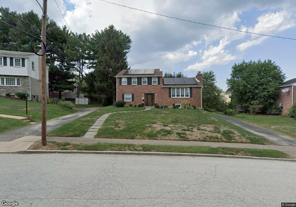
146 Harned Dr Springfield, PA 19064
Estimated Value: $528,000 - $725,000
3
Beds
2
Baths
1,845
Sq Ft
$323/Sq Ft
Est. Value
About This Home
This home is located at 146 Harned Dr, Springfield, PA 19064 and is currently estimated at $596,545, approximately $323 per square foot. 146 Harned Dr is a home located in Delaware County with nearby schools including Springfield High School, St Francis Of Assisi School, and St Dorothy School.
Ownership History
Date
Name
Owned For
Owner Type
Purchase Details
Closed on
Nov 17, 2020
Sold by
Home At Last Properties Llc
Bought by
Murphy Kathryn and Escalona Daniel Herrero
Current Estimated Value
Home Financials for this Owner
Home Financials are based on the most recent Mortgage that was taken out on this home.
Original Mortgage
$367,500
Interest Rate
2.71%
Mortgage Type
New Conventional
Purchase Details
Closed on
May 1, 2020
Sold by
Recke Edward M
Bought by
Home At Last Properties Llc
Home Financials for this Owner
Home Financials are based on the most recent Mortgage that was taken out on this home.
Original Mortgage
$270,000
Interest Rate
3.3%
Mortgage Type
Credit Line Revolving
Purchase Details
Closed on
Oct 7, 1988
Sold by
Broome Gilbert H
Bought by
Recke Edward M and Recke Patricia M
Create a Home Valuation Report for This Property
The Home Valuation Report is an in-depth analysis detailing your home's value as well as a comparison with similar homes in the area
Home Values in the Area
Average Home Value in this Area
Purchase History
| Date | Buyer | Sale Price | Title Company |
|---|---|---|---|
| Murphy Kathryn | $490,000 | Terra Abstract Inc | |
| Murphy Kathryn | $490,000 | Terra Abstract | |
| Home At Last Properties Llc | $250,000 | Prosperity Abstract Llc | |
| Recke Edward M | $146,000 | -- |
Source: Public Records
Mortgage History
| Date | Status | Borrower | Loan Amount |
|---|---|---|---|
| Previous Owner | Murphy Kathryn | $367,500 | |
| Previous Owner | Home At Last Properties Llc | $270,000 |
Source: Public Records
Tax History Compared to Growth
Tax History
| Year | Tax Paid | Tax Assessment Tax Assessment Total Assessment is a certain percentage of the fair market value that is determined by local assessors to be the total taxable value of land and additions on the property. | Land | Improvement |
|---|---|---|---|---|
| 2025 | $7,204 | $256,290 | $100,420 | $155,870 |
| 2024 | $7,204 | $256,290 | $100,420 | $155,870 |
| 2023 | $6,936 | $256,290 | $100,420 | $155,870 |
| 2022 | $6,786 | $256,290 | $100,420 | $155,870 |
| 2021 | $10,510 | $256,290 | $100,420 | $155,870 |
| 2020 | $6,684 | $147,500 | $48,280 | $99,220 |
| 2019 | $6,527 | $147,500 | $48,280 | $99,220 |
| 2018 | $6,433 | $147,500 | $0 | $0 |
| 2017 | $6,285 | $147,500 | $0 | $0 |
| 2016 | $809 | $147,500 | $0 | $0 |
| 2015 | $826 | $147,500 | $0 | $0 |
| 2014 | $826 | $147,500 | $0 | $0 |
Source: Public Records
Map
Nearby Homes
- 200 N State Rd
- 38 S Britton Rd
- 530 Hempstead Rd
- 201 S Highland Rd
- 140 N Rolling Rd
- 232 S Highland Rd
- 63 S Hillcrest Rd
- 444 Kerr Ln
- 30 Wayne Ave
- 89 Saxer Ave
- 517 W Woodland Ave
- 412 N Rolling Rd
- 15 Pearson Dr
- 224 Ballymore Rd
- 341 Kennerly Rd
- 658 W Rolling Rd
- 158 Hillview Dr
- 214 Lynbrooke Rd
- 225 Lynbrooke Rd
- 230 Ridgewood Rd
- 148 Harned Rd
- 142 Harned Dr
- 232 Parkview Dr
- 145 Grandview Rd
- 151 Grandview Rd
- 141 Grandview Rd
- 155 Grandview Rd
- 138 Harned Dr
- 147 Harned Rd
- 147 Harned Dr
- 137 Grandview Rd
- 139 Harned Dr
- 231 Parkview Dr
- 134 Harned Dr
- 235 Parkview Dr
- 227 Parkview Dr
- 169 Grandview Rd
- 220 Parkview Dr
- 133 Grandview Rd
- 152 Grandview Rd