
Landlord's Agent in 2025
John Boss
Berkshire Hathaway HomeServices Evolution Properties
(508) 838-3321
125 Total Sales


Estimated Value: $638,000 - $741,000
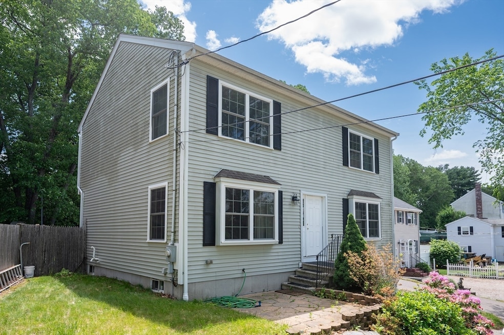
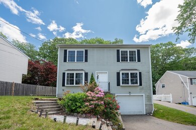
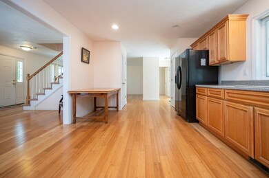
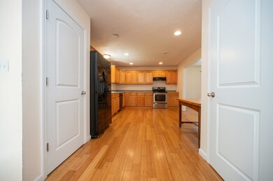
Live in comfort and style in this beautifully maintained 2/3 bedroom, 2.5 bath home located in a sought-after neighborhood with private access to Lake Archer! This elegant home features gleaming hardwood floors, a flexible floor plan with optional third bedroom or office, and a bright, modern kitchen. The spacious fenced-in yard is perfect for outdoor entertaining or relaxing in privacy. Additional perks include an unfinished basement for storage, a 1-car garage, and off-street parking. Enjoy peaceful lakeside living while still being close to town amenities and commuter routes. Ideal for renters seeking quality, space, and location. First, last, and security deposit required. Strong credit and references a must. No smoking. Don’t miss out on this rare rental opportunity near the water—schedule your private tour today!
| Date | Buyer | Sale Price | Title Company |
|---|---|---|---|
| Sousa Mirian A | $120,000 | -- |
| Date | Status | Borrower | Loan Amount |
|---|---|---|---|
| Open | Sousa Mirian A | $200,000 |
| Date | Event | Price | List to Sale | Price per Sq Ft |
|---|---|---|---|---|
| 08/27/2025 08/27/25 | Rented | $3,550 | -1.4% | -- |
| 08/19/2025 08/19/25 | Under Contract | -- | -- | -- |
| 08/05/2025 08/05/25 | Price Changed | $3,600 | -5.3% | $2 / Sq Ft |
| 06/26/2025 06/26/25 | Price Changed | $3,800 | -5.0% | $2 / Sq Ft |
| 06/05/2025 06/05/25 | For Rent | $4,000 | -- | -- |
| Year | Tax Paid | Tax Assessment Tax Assessment Total Assessment is a certain percentage of the fair market value that is determined by local assessors to be the total taxable value of land and additions on the property. | Land | Improvement |
|---|---|---|---|---|
| 2025 | $6,857 | $591,600 | $269,500 | $322,100 |
| 2024 | $6,652 | $554,300 | $269,500 | $284,800 |
| 2023 | $6,313 | $500,200 | $245,000 | $255,200 |
| 2022 | $5,596 | $409,400 | $188,600 | $220,800 |
| 2021 | $5,645 | $401,200 | $197,600 | $203,600 |
| 2020 | $5,700 | $400,000 | $178,300 | $221,700 |
| 2019 | $5,315 | $376,400 | $164,600 | $211,800 |
| 2018 | $4,971 | $349,100 | $165,300 | $183,800 |
| 2017 | $4,681 | $328,500 | $162,100 | $166,400 |
| 2016 | $4,602 | $322,300 | $157,400 | $164,900 |
| 2015 | $4,463 | $297,900 | $151,300 | $146,600 |
| 2014 | $4,412 | $288,200 | $145,500 | $142,700 |
Landlord's Agent in 2025
John Boss
Berkshire Hathaway HomeServices Evolution Properties
(508) 838-3321
125 Total Sales
Source: MLS Property Information Network (MLS PIN)
MLS Number: 73386007
APN: WREN-000009L-000006-000003
Disclaimer: Certain information contained herein is derived from information provided by parties other than Homes.com. All information provided is deemed reliable, but is not guaranteed to be accurate and should be independently verified.
![]() The property listing data and information, or the Images, set forth herein were provided to MLS Property Information Network, Inc. from third party sources, including sellers, lessors and public records, and were compiled by MLS Property Information Network, Inc. The property listing data and information, and the Images, are for the personal, non-commercial use of consumers having a good faith interest in purchasing or leasing listed properties of the type displayed to them and may not be used for any purpose other than to identify prospective properties which such consumers may have a good faith interest in purchasing or leasing. MLS Property Information Network, Inc. and its subscribers disclaim any and all representations and warranties as to the accuracy of the property listing data and information, or as to the accuracy of any of the Images, set forth herein.
The property listing data and information, or the Images, set forth herein were provided to MLS Property Information Network, Inc. from third party sources, including sellers, lessors and public records, and were compiled by MLS Property Information Network, Inc. The property listing data and information, and the Images, are for the personal, non-commercial use of consumers having a good faith interest in purchasing or leasing listed properties of the type displayed to them and may not be used for any purpose other than to identify prospective properties which such consumers may have a good faith interest in purchasing or leasing. MLS Property Information Network, Inc. and its subscribers disclaim any and all representations and warranties as to the accuracy of the property listing data and information, or as to the accuracy of any of the Images, set forth herein.
Ask me questions while you tour the home.