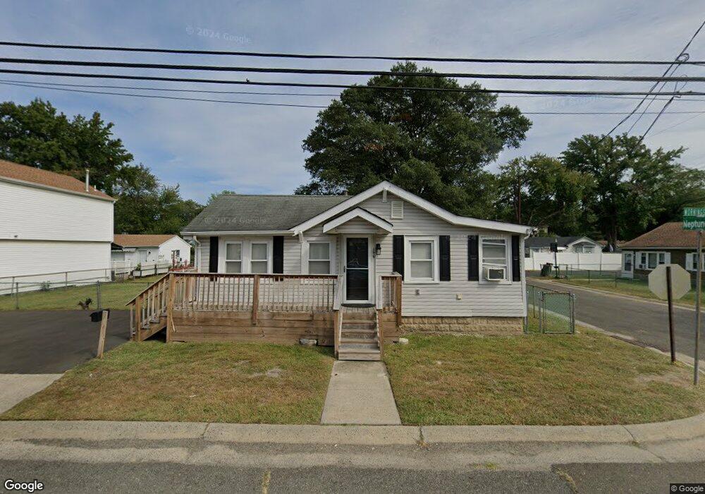
146 Morningside Ave North Middletown, NJ 07748
Estimated Value: $401,000 - $453,000
3
Beds
1
Bath
1,257
Sq Ft
$335/Sq Ft
Est. Value
About This Home
This home is located at 146 Morningside Ave, North Middletown, NJ 07748 and is currently estimated at $420,607, approximately $334 per square foot. 146 Morningside Ave is a home located in Monmouth County with nearby schools including Ocean Avenue Elementary School, Thorne Middle School, and Middletown High School North.
Ownership History
Date
Name
Owned For
Owner Type
Purchase Details
Closed on
Apr 3, 2009
Sold by
Estate Of Whilma L Marinelli and Smith Michael
Bought by
Marinelli Christopher and Marinelli Michael L
Current Estimated Value
Home Financials for this Owner
Home Financials are based on the most recent Mortgage that was taken out on this home.
Original Mortgage
$183,150
Interest Rate
4.94%
Mortgage Type
FHA
Create a Home Valuation Report for This Property
The Home Valuation Report is an in-depth analysis detailing your home's value as well as a comparison with similar homes in the area
Home Values in the Area
Average Home Value in this Area
Purchase History
| Date | Buyer | Sale Price | Title Company |
|---|---|---|---|
| Marinelli Christopher | $187,000 | Avalon Title Agency Llc |
Source: Public Records
Mortgage History
| Date | Status | Borrower | Loan Amount |
|---|---|---|---|
| Closed | Marinelli Christopher | $183,150 |
Source: Public Records
Tax History Compared to Growth
Tax History
| Year | Tax Paid | Tax Assessment Tax Assessment Total Assessment is a certain percentage of the fair market value that is determined by local assessors to be the total taxable value of land and additions on the property. | Land | Improvement |
|---|---|---|---|---|
| 2025 | $5,983 | $390,500 | $256,600 | $133,900 |
| 2024 | $5,303 | $363,700 | $232,300 | $131,400 |
| 2023 | $5,303 | $305,100 | $209,500 | $95,600 |
| 2022 | $4,437 | $265,600 | $174,600 | $91,000 |
| 2021 | $4,437 | $213,300 | $132,400 | $80,900 |
| 2020 | $4,276 | $200,000 | $120,900 | $79,100 |
| 2019 | $4,325 | $204,800 | $123,100 | $81,700 |
| 2018 | $5,639 | $260,200 | $182,300 | $77,900 |
| 2017 | $4,855 | $221,800 | $146,300 | $75,500 |
| 2016 | $3,740 | $175,500 | $96,300 | $79,200 |
| 2015 | $3,873 | $175,500 | $96,300 | $79,200 |
| 2014 | $4,383 | $193,700 | $121,300 | $72,400 |
Source: Public Records
Map
Nearby Homes
- 71 Bay Ave
- 289 Port Monmouth Rd
- 31 Ocean Ave
- 210 Ocean Ave
- 173 Forest Ave
- 170 Park Ave
- 31 Monmouth Ave
- 98 Seabreeze Ave
- 10 Morningside Ave
- 231 Shore Blvd
- 12 Orchard St
- 123 Forest Ave
- 11 Snyder Ave
- 166 Shore Blvd
- 280 Linden Ave
- 270 Main St Unit 6
- 91 Monmouth Ave
- 795 Harmony Rd
- 151 Shore Blvd
- 93 Monmouth Ave
- 144 Morningside Ave
- 43 Neptune Place
- 140 Morningside Ave
- 47 Neptune Place
- 50 Dalby Place
- 44 Dalby Place
- 44 Neptune Place
- 147 Morningside Ave
- 143 Morningside Ave
- 160 Morningside Ave
- 49 Neptune Place
- 48 Neptune Place
- 141 Morningside Ave
- 26 Neptune Place
- 162 Morningside Ave
- 223 Atlantic Ave
- 137 Morningside Ave
- 51 Neptune Place
- 52 Neptune Place
- 159 Morningside Ave