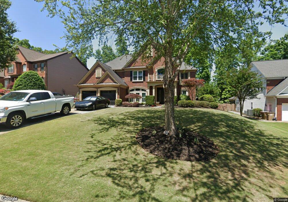
1460 Mountclaire Dr Cumming, GA 30041
Big Creek NeighborhoodEstimated Value: $793,000 - $851,000
5
Beds
4
Baths
3,748
Sq Ft
$221/Sq Ft
Est. Value
About This Home
This home is located at 1460 Mountclaire Dr, Cumming, GA 30041 and is currently estimated at $828,111, approximately $220 per square foot. 1460 Mountclaire Dr is a home located in Forsyth County with nearby schools including Shiloh Point Elementary School, Piney Grove Middle School, and South Forsyth High School.
Ownership History
Date
Name
Owned For
Owner Type
Purchase Details
Closed on
Nov 19, 2012
Sold by
Ferguson Mark
Bought by
Ferguson Lorraine
Current Estimated Value
Purchase Details
Closed on
Aug 29, 2003
Sold by
Hausknecht Paul D
Bought by
Ferguson Lorraine and Ferguson Mark
Home Financials for this Owner
Home Financials are based on the most recent Mortgage that was taken out on this home.
Original Mortgage
$240,000
Interest Rate
6.13%
Mortgage Type
New Conventional
Purchase Details
Closed on
May 30, 2001
Sold by
Pulte Home Corp
Bought by
Hausknecht Paul D
Home Financials for this Owner
Home Financials are based on the most recent Mortgage that was taken out on this home.
Original Mortgage
$275,000
Interest Rate
7.11%
Mortgage Type
New Conventional
Create a Home Valuation Report for This Property
The Home Valuation Report is an in-depth analysis detailing your home's value as well as a comparison with similar homes in the area
Home Values in the Area
Average Home Value in this Area
Purchase History
| Date | Buyer | Sale Price | Title Company |
|---|---|---|---|
| Ferguson Lorraine | -- | -- | |
| Ferguson Lorraine | $300,000 | -- | |
| Hausknecht Paul D | $294,900 | -- |
Source: Public Records
Mortgage History
| Date | Status | Borrower | Loan Amount |
|---|---|---|---|
| Previous Owner | Ferguson Lorraine | $240,000 | |
| Previous Owner | Hausknecht Paul D | $275,000 |
Source: Public Records
Tax History Compared to Growth
Tax History
| Year | Tax Paid | Tax Assessment Tax Assessment Total Assessment is a certain percentage of the fair market value that is determined by local assessors to be the total taxable value of land and additions on the property. | Land | Improvement |
|---|---|---|---|---|
| 2025 | $6,066 | $313,520 | $74,000 | $239,520 |
| 2024 | $6,066 | $301,092 | $68,000 | $233,092 |
| 2023 | $4,950 | $255,712 | $60,000 | $195,712 |
| 2022 | $5,345 | $186,388 | $40,000 | $146,388 |
| 2021 | $4,683 | $186,388 | $40,000 | $146,388 |
| 2020 | $4,386 | $172,020 | $40,000 | $132,020 |
| 2019 | $4,319 | $168,444 | $40,000 | $128,444 |
| 2018 | $4,364 | $169,864 | $32,000 | $137,864 |
| 2017 | $4,298 | $165,920 | $32,000 | $133,920 |
| 2016 | $4,171 | $159,920 | $26,000 | $133,920 |
| 2015 | $3,901 | $146,816 | $26,000 | $120,816 |
| 2014 | $3,309 | $128,276 | $0 | $0 |
Source: Public Records
Map
Nearby Homes
- 2260 Thames Ct
- 2255 Windsor Bluffs Dr
- 2250 Thames Ct
- 1255 Bookhout Dr
- The Oxford Plan at Windsor Bluffs
- The Cambridge Plan at Windsor Bluffs
- The Berkshire Plan at Windsor Bluffs
- 1065 Bookhout Dr
- 1740 Cobble Creek Way
- 1330 Badingham Dr
- 1475 Badingham Dr
- 1460 Badingham Dr
- 2530 Wellsley Ln
- 1555 Diplomat Dr
- 1430 Diplomat Dr
- 2415 Stewart Rd
- 2450 Bleckley Place
- 2405 Stewart Rd
- 1315 Seneca Ave
- 1510 Mountclaire Dr Unit II
- 1450 Mountclaire Dr
- 1585 Laleiah Dr
- 1585 Laleiah Dr
- 1585 Laleiah Dr Unit 1585
- 1520 Mountclaire Dr
- 1575 Laleiah Dr
- 1440 Mountclaire Dr
- 1455 Mountclaire Dr
- 1595 Laleiah Dr Unit 1
- 1510 Aurelia Dr Unit I
- 1555 Laleiah Dr Unit 49
- 1555 Laleiah Dr
- 1530 Mountclaire Dr Unit II
- 1430 Mountclaire Dr
- 1545 Laleiah Dr Unit I
- 1605 Laleiah Dr
- 0 Laleiah Dr Unit 8726290
- 0 Laleiah Dr Unit 8597169
- 0 Laleiah Dr Unit 8567303