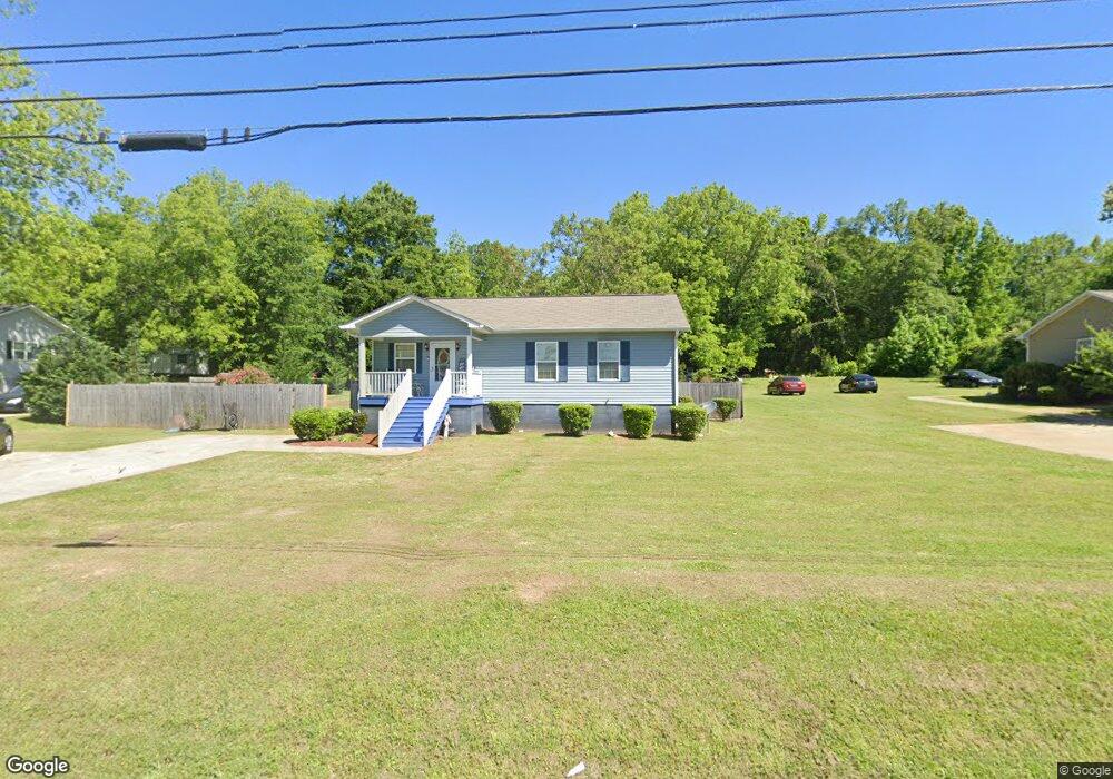
1460 N Rhodes St Union Point, GA 30669
Estimated Value: $191,000 - $223,000
3
Beds
2
Baths
1,120
Sq Ft
$179/Sq Ft
Est. Value
About This Home
This home is located at 1460 N Rhodes St, Union Point, GA 30669 and is currently estimated at $200,795, approximately $179 per square foot. 1460 N Rhodes St is a home with nearby schools including Greene County High School.
Ownership History
Date
Name
Owned For
Owner Type
Purchase Details
Closed on
Jan 23, 2017
Bought by
Robbins Kirby
Current Estimated Value
Purchase Details
Closed on
Dec 14, 2012
Sold by
Greenwood Likitia and Howard Sm
Bought by
Greene Co Habitat For Humanity
Purchase Details
Closed on
Nov 6, 2012
Sold by
Lawson Candace T Sheriff
Bought by
Greene County Habitat For Huma
Purchase Details
Closed on
Jan 5, 1999
Sold by
Smith Lula M and Smith Frank H
Bought by
Greenwood Likitia and Howard Sm
Purchase Details
Closed on
Jan 1, 1980
Sold by
Harper William
Bought by
Smith Lula M and Smith Frank H
Purchase Details
Closed on
Jan 1, 1975
Sold by
Vaughn J D
Bought by
Harper William
Purchase Details
Closed on
Jan 1, 1968
Sold by
Lyons William
Bought by
Vaughn J D
Purchase Details
Closed on
Jan 1, 1945
Bought by
Lyons William
Create a Home Valuation Report for This Property
The Home Valuation Report is an in-depth analysis detailing your home's value as well as a comparison with similar homes in the area
Home Values in the Area
Average Home Value in this Area
Purchase History
| Date | Buyer | Sale Price | Title Company |
|---|---|---|---|
| Robbins Kirby | -- | -- | |
| Greene Co Habitat For Humanity | -- | -- | |
| Greene County Habitat For Huma | $524 | -- | |
| Greenwood Likitia | -- | -- | |
| Smith Lula M | -- | -- | |
| Harper William | -- | -- | |
| Vaughn J D | -- | -- | |
| Lyons William | -- | -- |
Source: Public Records
Tax History Compared to Growth
Tax History
| Year | Tax Paid | Tax Assessment Tax Assessment Total Assessment is a certain percentage of the fair market value that is determined by local assessors to be the total taxable value of land and additions on the property. | Land | Improvement |
|---|---|---|---|---|
| 2024 | $1,113 | $65,640 | $8,040 | $57,600 |
| 2023 | $404 | $62,200 | $8,040 | $54,160 |
| 2022 | $661 | $55,880 | $8,040 | $47,840 |
| 2021 | $686 | $50,360 | $8,040 | $42,320 |
| 2020 | $735 | $30,440 | $3,360 | $27,080 |
| 2019 | $762 | $30,440 | $3,360 | $27,080 |
| 2018 | $623 | $30,440 | $3,360 | $27,080 |
| 2017 | $689 | $30,461 | $3,375 | $27,086 |
| 2016 | -- | $3,375 | $3,375 | $0 |
| 2015 | -- | $3,375 | $3,375 | $0 |
| 2014 | -- | $3,375 | $3,375 | $0 |
Source: Public Records
Map
Nearby Homes
- 0 Woodland Ct Unit 10543600
- 324 N Rhodes St
- 202 Veazey St
- 1860 Washington Hwy
- 112 Hendry St
- 215 Hunter St
- 0 S Rhodes St Unit 10618488
- 1041 Hillcrest Dr
- 0 Washington Hwy Unit 7276060
- 1241 Old Siloam Rd
- 5401 Union Point Hwy
- 1201 Buffalo Lick Rd
- 0 Buffalo Lick Rd Unit 10551234
- 0 Buffalo Lick Rd Unit 10551325
- 1581 Highway 77 S
- 1581 Highway 77 S Hwy
- 1251 Adams Rd
- 0 Old Union Point Rd Unit 1 10557753
- 1251 Brick House Rd
- 1251 Brickhouse Rd
- 1482 N Rhodes St
- 1450 N Rhodes St
- 1440 N Rhodes St
- 1420 N Rhodes St
- 1421 N Rhodes St
- 1410 N Rhodes St
- 1521 N Rhodes St
- 1401 N Rhodes St
- 1400 N Rhodes St
- 1551 N Rhodes St
- 1391 N Rhodes St
- 1561 N Rhodes St
- 623 Woodland Ct
- 625 Woodland Ct
- 1570 N Rhodes St
- 621 Woodland Ct
- 624 Woodland Ct
- 619 Woodland Ct
- N N Rhodes St
- 622 Woodland Ct