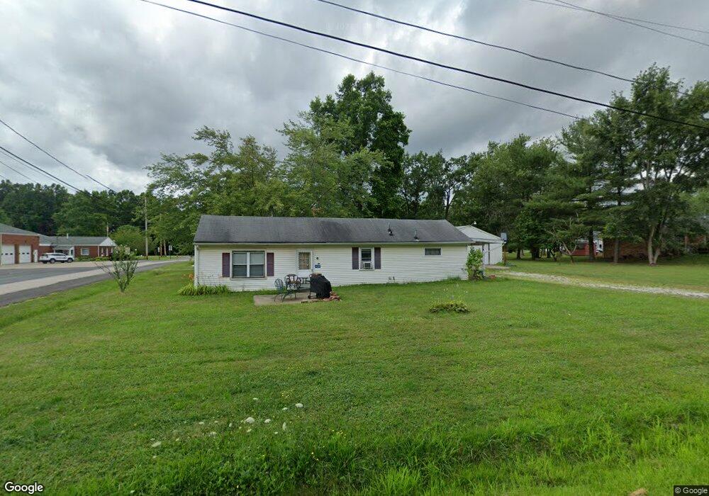
14600 Spruce Dr NE Alliance, OH 44601
Estimated Value: $106,612 - $160,000
3
Beds
1
Bath
1,000
Sq Ft
$124/Sq Ft
Est. Value
About This Home
This home is located at 14600 Spruce Dr NE, Alliance, OH 44601 and is currently estimated at $123,653, approximately $123 per square foot. 14600 Spruce Dr NE is a home located in Stark County with nearby schools including Marlington High School and Regina Coeli/St Joseph School.
Ownership History
Date
Name
Owned For
Owner Type
Purchase Details
Closed on
Feb 14, 2018
Sold by
Gibson Lela
Bought by
Yoho Margaret
Current Estimated Value
Home Financials for this Owner
Home Financials are based on the most recent Mortgage that was taken out on this home.
Original Mortgage
$25,705
Outstanding Balance
$21,748
Interest Rate
3.95%
Mortgage Type
New Conventional
Estimated Equity
$101,905
Create a Home Valuation Report for This Property
The Home Valuation Report is an in-depth analysis detailing your home's value as well as a comparison with similar homes in the area
Home Values in the Area
Average Home Value in this Area
Purchase History
| Date | Buyer | Sale Price | Title Company |
|---|---|---|---|
| Yoho Margaret | $26,500 | None Available |
Source: Public Records
Mortgage History
| Date | Status | Borrower | Loan Amount |
|---|---|---|---|
| Open | Yoho Margaret | $25,705 |
Source: Public Records
Tax History Compared to Growth
Tax History
| Year | Tax Paid | Tax Assessment Tax Assessment Total Assessment is a certain percentage of the fair market value that is determined by local assessors to be the total taxable value of land and additions on the property. | Land | Improvement |
|---|---|---|---|---|
| 2025 | -- | $21,600 | $9,560 | $12,040 |
| 2024 | -- | $21,600 | $9,560 | $12,040 |
| 2023 | $613 | $17,400 | $3,570 | $13,830 |
| 2022 | $615 | $17,400 | $3,570 | $13,830 |
| 2021 | $617 | $17,400 | $3,570 | $13,830 |
| 2020 | $609 | $15,300 | $3,080 | $12,220 |
| 2019 | $605 | $15,300 | $3,080 | $12,220 |
| 2018 | $259 | $15,300 | $3,080 | $12,220 |
| 2017 | $241 | $14,460 | $1,650 | $12,810 |
| 2016 | $241 | $14,460 | $1,650 | $12,810 |
| 2015 | $70 | $14,460 | $1,650 | $12,810 |
| 2014 | $164 | $12,460 | $1,400 | $11,060 |
| 2013 | $13 | $12,460 | $1,400 | $11,060 |
Source: Public Records
Map
Nearby Homes
- 14422 Sturbridge Rd NE
- 14723 Bolton St NE
- 0 Johnson Ave NE Unit 5142926
- 0 Homestead Ave NE
- 0 Klinger Ave NE
- 0 Meadowbrook Ave
- 000 Klinger Ave
- 11480 Aebi Ave NE
- 432 Johnson Ave
- 11344 Walnut Ave NE
- 15520 Coalbank St NE
- 511 W Ely St
- 505 N Union Ave
- 124 E Wayne St
- 13109 Edison St NE
- 15832 Waverly St NE
- 710 N Freedom Ave
- 15995 Elbrook St NE
- 0 Knoll St NE
- 11310 Webb Ave NE
- 14600 Spruce Dr NE
- 14578 Spruce Dr NE
- 14551 Gaskill Dr NE
- 14521 Gaskill Dr NE
- 11931 Northside Rd NE
- 14585 Spruce Dr NE
- 14566 Spruce Dr NE
- 14633 Spruce Dr NE
- 14571 Gaskill Dr NE
- 14644 Spruce Dr NE
- 14573 Spruce Dr NE
- 14491 Gaskill Dr NE
- 11950 Northside Rd NE
- 14596 Ardmore Dr NE
- 14550 Spruce Dr NE
- 14530 Gaskill Dr NE
- 14577 Gaskill Dr NE
- 14585 Gaskill Dr NE
- 14660 Spruce Dr NE
- 14481 Gaskill Dr NE