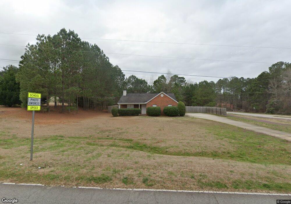
1462 Stroud Rd McDonough, GA 30252
Estimated Value: $269,000 - $292,000
3
Beds
2
Baths
1,410
Sq Ft
$198/Sq Ft
Est. Value
About This Home
This home is located at 1462 Stroud Rd, McDonough, GA 30252 and is currently estimated at $279,079, approximately $197 per square foot. 1462 Stroud Rd is a home located in Henry County with nearby schools including Rock Spring Elementary School, Ola Middle School, and Ola High School.
Ownership History
Date
Name
Owned For
Owner Type
Purchase Details
Closed on
Jun 16, 2016
Sold by
Lb Ryan Holdings Llc
Bought by
Kb Business Investments Llc
Current Estimated Value
Purchase Details
Closed on
Oct 19, 2012
Sold by
Black Christopher
Bought by
Medlock Sharon
Purchase Details
Closed on
Jun 18, 2010
Sold by
Wilson Timothy L
Bought by
Pbear Group Llc
Purchase Details
Closed on
Jan 12, 2010
Sold by
Pbear Group Llc
Bought by
Wilson Timothy L
Home Financials for this Owner
Home Financials are based on the most recent Mortgage that was taken out on this home.
Original Mortgage
$87,500
Interest Rate
4.94%
Create a Home Valuation Report for This Property
The Home Valuation Report is an in-depth analysis detailing your home's value as well as a comparison with similar homes in the area
Home Values in the Area
Average Home Value in this Area
Purchase History
| Date | Buyer | Sale Price | Title Company |
|---|---|---|---|
| Kb Business Investments Llc | $80,000 | -- | |
| Medlock Sharon | -- | -- | |
| Medlock Sharon | -- | -- | |
| Medlock Lindsay | -- | -- | |
| Medlock Sharon | -- | -- | |
| Lb Ryan Holdings Llc | -- | -- | |
| Pbear Group Llc | $5,000 | -- | |
| Wilson Timothy L | $75,000 | -- |
Source: Public Records
Mortgage History
| Date | Status | Borrower | Loan Amount |
|---|---|---|---|
| Previous Owner | Wilson Timothy L | $87,500 |
Source: Public Records
Tax History Compared to Growth
Tax History
| Year | Tax Paid | Tax Assessment Tax Assessment Total Assessment is a certain percentage of the fair market value that is determined by local assessors to be the total taxable value of land and additions on the property. | Land | Improvement |
|---|---|---|---|---|
| 2024 | $4,395 | $109,600 | $13,680 | $95,920 |
| 2023 | $4,169 | $107,640 | $13,160 | $94,480 |
| 2022 | $3,271 | $84,240 | $12,160 | $72,080 |
| 2021 | $2,566 | $65,840 | $10,440 | $55,400 |
| 2020 | $2,200 | $60,720 | $9,800 | $50,920 |
| 2019 | $2,200 | $56,320 | $9,320 | $47,000 |
| 2018 | $0 | $51,280 | $8,600 | $42,680 |
| 2016 | $1,723 | $43,880 | $6,400 | $37,480 |
| 2015 | $1,592 | $39,240 | $7,200 | $32,040 |
| 2014 | $1,534 | $37,320 | $7,200 | $30,120 |
Source: Public Records
Map
Nearby Homes
- 518 Gallantry Trail
- 1120 Stroud Rd
- 1100 Stroud Rd
- 209 Amber Ct
- 41 Giles Dr
- 106 Loam Dr
- 320 Ponderosa Trail
- 58 Maddox Dr
- 68 Maddox Dr
- 78 Maddox Dr
- 88 Maddox Dr
- 227 Aves Ct
- 106 Meadow View Dr
- 1120 Jackson Lake Rd
- 1190 Jackson Lake Rd
- 1130 Jackson Lake Rd
- 0 Fincherville Rd Tract #3 Unit 10435292
- 0 Fincherville Rd Unit TRACT 2 10435272
- 104 Armory Creek Dr
- 2082 Stroud Rd
- 1464 Stroud Rd
- 1454 Stroud Rd
- 100 Worthy Dr
- 205 Carlin Ct
- 102 Worthy Dr
- 1452 Stroud Rd
- 1395 Stroud Rd
- 215 Carlin Ct
- 200 Carlin Ct
- 104 Worthy Dr Unit 42
- 1450 Stroud Rd
- 1448 Stroud Rd Unit 6
- 1448 Stroud Rd
- 0 Carlin Ct Unit 8820849
- 0 Carlin Ct Unit 8713408
- 0 Carlin Ct Unit 8126736
- 0 Carlin Ct
- 225 Carlin Ct
- 150 Worthy Dr
- 106 Worthy Dr