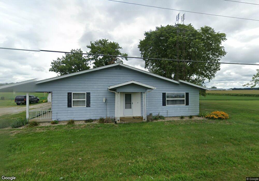
14639 State Route 118 New Weston, OH 45348
Estimated Value: $185,000 - $288,000
2
Beds
2
Baths
74,052
Sq Ft
$3/Sq Ft
Est. Value
About This Home
This home is located at 14639 State Route 118, New Weston, OH 45348 and is currently estimated at $219,711, approximately $2 per square foot. 14639 State Route 118 is a home located in Darke County with nearby schools including Ansonia Elementary School, Ansonia Middle School, and Ansonia High School.
Ownership History
Date
Name
Owned For
Owner Type
Purchase Details
Closed on
Jun 26, 2025
Sold by
Geier Brent C and Geier Kimberly R
Bought by
Geier Brent C and Geier Kimberly R
Current Estimated Value
Purchase Details
Closed on
Nov 8, 2013
Sold by
Kunk Kyle J and Kunk Josie A
Bought by
Geier Brent C and Geier Kimberly R
Home Financials for this Owner
Home Financials are based on the most recent Mortgage that was taken out on this home.
Original Mortgage
$118,750
Interest Rate
4.23%
Mortgage Type
New Conventional
Purchase Details
Closed on
Jan 18, 2007
Sold by
Gelhaus William H
Bought by
Kunk Kyle J and Thieman Josie A
Home Financials for this Owner
Home Financials are based on the most recent Mortgage that was taken out on this home.
Original Mortgage
$110,400
Interest Rate
6.21%
Mortgage Type
Purchase Money Mortgage
Purchase Details
Closed on
Aug 1, 1990
Bought by
Geier Brent C and Geier Kimberly K
Create a Home Valuation Report for This Property
The Home Valuation Report is an in-depth analysis detailing your home's value as well as a comparison with similar homes in the area
Home Values in the Area
Average Home Value in this Area
Purchase History
| Date | Buyer | Sale Price | Title Company |
|---|---|---|---|
| Geier Brent C | -- | None Listed On Document | |
| Geier Brent C | -- | None Listed On Document | |
| Geier Brent C | $187,500 | Attorney | |
| Kunk Kyle J | $138,000 | Attorney | |
| Geier Brent C | $73,000 | -- |
Source: Public Records
Mortgage History
| Date | Status | Borrower | Loan Amount |
|---|---|---|---|
| Previous Owner | Geier Brent C | $118,750 | |
| Previous Owner | Kunk Kyle J | $110,400 |
Source: Public Records
Tax History Compared to Growth
Tax History
| Year | Tax Paid | Tax Assessment Tax Assessment Total Assessment is a certain percentage of the fair market value that is determined by local assessors to be the total taxable value of land and additions on the property. | Land | Improvement |
|---|---|---|---|---|
| 2024 | $1,579 | $50,550 | $9,000 | $41,550 |
| 2023 | $1,581 | $50,550 | $9,000 | $41,550 |
| 2022 | $1,773 | $49,180 | $7,670 | $41,510 |
| 2021 | $1,760 | $49,180 | $7,670 | $41,510 |
| 2020 | $1,765 | $49,180 | $7,670 | $41,510 |
| 2019 | $1,498 | $43,770 | $7,670 | $36,100 |
| 2018 | $1,503 | $43,770 | $7,670 | $36,100 |
| 2017 | $1,291 | $43,770 | $7,670 | $36,100 |
| 2016 | $1,292 | $40,650 | $7,180 | $33,470 |
| 2015 | $1,292 | $40,650 | $7,180 | $33,470 |
| 2014 | $1,292 | $40,650 | $7,180 | $33,470 |
| 2013 | $887 | $25,730 | $6,900 | $18,830 |
Source: Public Records
Map
Nearby Homes
- 4475 Ohio 705
- 21 E Star Rd
- 45 Cassella Montezuma Rd
- 63 Cassella-Montezuma Rd
- 4543 Lange Rd
- 3709 Rossburg-Lightsville Rd
- 0 Ohio 118
- 159 Mendenhall Rd
- 158 Mendenhall Rd
- 157 Mendenhall Rd
- 140 Liberty Dr
- 139 Liberty Dr
- 136 Liberty Dr
- 137 Liberty Dr
- 141 Liberty Dr
- 138 Liberty Dr
- 142 Liberty Dr
- 144 Liberty Dr
- 135 Veterans Dr
- 143 Liberty Dr