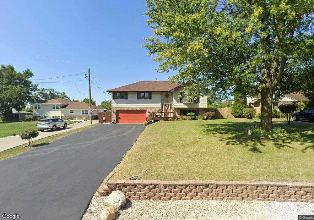
14640 Smith Rd Lockport, IL 60441
Big Run NeighborhoodEstimated Value: $345,926 - $439,000
Studio
1
Bath
2,106
Sq Ft
$184/Sq Ft
Est. Value
About This Home
This home is located at 14640 Smith Rd, Lockport, IL 60441 and is currently estimated at $387,732, approximately $184 per square foot. 14640 Smith Rd is a home located in Will County with nearby schools including Ludwig Elementary School, Walsh Elementary School, and Reed Elementary School.
Ownership History
Date
Name
Owned For
Owner Type
Purchase Details
Closed on
Sep 17, 1999
Sold by
Federal National Mortgage Association
Bought by
Feirn Robert W and Feirn Sandra L
Current Estimated Value
Home Financials for this Owner
Home Financials are based on the most recent Mortgage that was taken out on this home.
Original Mortgage
$128,000
Interest Rate
8.21%
Purchase Details
Closed on
Aug 13, 1999
Sold by
Leske Jeffrey J and Leske Leslie E
Bought by
Federal National Mortgage Association
Home Financials for this Owner
Home Financials are based on the most recent Mortgage that was taken out on this home.
Original Mortgage
$128,000
Interest Rate
8.21%
Purchase Details
Closed on
Dec 21, 1992
Bought by
Feirn Robert W S
Create a Home Valuation Report for This Property
The Home Valuation Report is an in-depth analysis detailing your home's value as well as a comparison with similar homes in the area
Home Values in the Area
Average Home Value in this Area
Purchase History
| Date | Buyer | Sale Price | Title Company |
|---|---|---|---|
| Feirn Robert W | -- | Intercounty Title | |
| Federal National Mortgage Association | -- | Wheatland Title | |
| Feirn Robert W S | $131,500 | -- |
Source: Public Records
Mortgage History
| Date | Status | Borrower | Loan Amount |
|---|---|---|---|
| Closed | Feirn Robert W | $128,000 |
Source: Public Records
Tax History
| Year | Tax Paid | Tax Assessment Tax Assessment Total Assessment is a certain percentage of the fair market value that is determined by local assessors to be the total taxable value of land and additions on the property. | Land | Improvement |
|---|---|---|---|---|
| 2024 | $7,763 | $119,917 | $32,139 | $87,778 |
| 2023 | $7,763 | $107,655 | $28,853 | $78,802 |
| 2022 | $7,244 | $101,416 | $27,181 | $74,235 |
| 2021 | $6,770 | $95,307 | $25,544 | $69,763 |
| 2020 | $6,577 | $92,173 | $24,704 | $67,469 |
| 2019 | $6,169 | $87,368 | $23,416 | $63,952 |
| 2018 | $6,018 | $83,984 | $22,509 | $61,475 |
| 2017 | $5,704 | $79,283 | $21,249 | $58,034 |
| 2016 | $5,369 | $74,305 | $19,915 | $54,390 |
| 2015 | $5,236 | $70,700 | $18,949 | $51,751 |
| 2014 | $5,236 | $70,700 | $18,949 | $51,751 |
| 2013 | $5,236 | $72,143 | $19,336 | $52,807 |
Source: Public Records
Map
Nearby Homes
- 1400 Smith Rd
- 14934 S Hillside Dr
- 1336 Tralee Ln
- 16656 W Huntington Dr
- 16542 Golden Valley Ln
- 16535 Golden Valley Ln
- 14838 S Hillside Dr
- 0 151st & MacGregor St Unit MRD11873272
- 0 Smith Rd South of 135th St Unit MRD12274096
- 0 N State St Unit 10995892
- 15303 S Oak Run Ct
- 904 Cove Ave
- 17528 Woodbrook Ln
- 14319 High Rd
- 16740 W Saddlewood Dr
- 514 N Lockwood Dr
- 805 Maryknoll Dr
- 14029 Cokes Rd
- 936 Treeline Ct Unit 5B
- 927 Treeline Ct Unit A
- 14634 Smith Rd
- 14652 Smith Rd
- 14664 S Smith Rd
- 14664 S Smith Rd
- 14635 Smith Rd
- 14622 Smith Rd
- 16761 W 147th Place
- 16756 W 147th Place
- 16755 W 147th Place Unit 1
- 16761 W 146th Place
- 16750 W 147th Place Unit 1
- 14615 Archer Ave
- 14604 Smith Rd
- 16755 W 146th Place
- 16744 W 147th Place
- 14601 Archer Ave
- 16743 W 147th Place Unit 1
- 16743 W 146th Place
- 16743 W 146th Place
- 14713 S Smith Rd
Your Personal Tour Guide
Ask me questions while you tour the home.