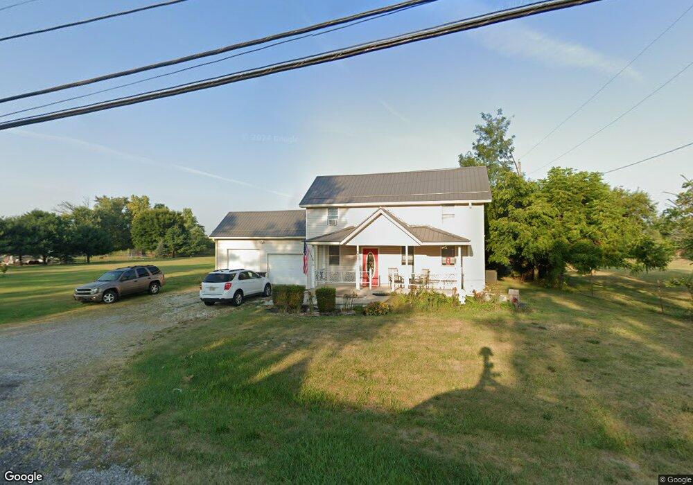
14660 State Route 56 SE Mount Sterling, OH 43143
Estimated Value: $298,000 - $363,000
3
Beds
2
Baths
1,664
Sq Ft
$204/Sq Ft
Est. Value
About This Home
This home is located at 14660 State Route 56 SE, Mount Sterling, OH 43143 and is currently estimated at $339,037, approximately $203 per square foot. 14660 State Route 56 SE is a home located in Madison County with nearby schools including Madison-Plains Elementary School, Madison-Plains Intermediate School, and Madison-Plains Junior High School.
Ownership History
Date
Name
Owned For
Owner Type
Purchase Details
Closed on
Aug 2, 2022
Sold by
Davis
Bought by
Lightfoot Jack D and Lightfoot Ellen
Current Estimated Value
Home Financials for this Owner
Home Financials are based on the most recent Mortgage that was taken out on this home.
Original Mortgage
$292,125
Outstanding Balance
$278,814
Interest Rate
5.3%
Mortgage Type
New Conventional
Estimated Equity
$60,223
Purchase Details
Closed on
Jun 2, 2022
Sold by
Joan Davis
Bought by
Davis J R
Create a Home Valuation Report for This Property
The Home Valuation Report is an in-depth analysis detailing your home's value as well as a comparison with similar homes in the area
Home Values in the Area
Average Home Value in this Area
Purchase History
| Date | Buyer | Sale Price | Title Company |
|---|---|---|---|
| Lightfoot Jack D | -- | Olix Thomas J | |
| Davis J R | -- | Budde Jospeh E |
Source: Public Records
Mortgage History
| Date | Status | Borrower | Loan Amount |
|---|---|---|---|
| Open | Lightfoot Jack D | $292,125 |
Source: Public Records
Tax History Compared to Growth
Tax History
| Year | Tax Paid | Tax Assessment Tax Assessment Total Assessment is a certain percentage of the fair market value that is determined by local assessors to be the total taxable value of land and additions on the property. | Land | Improvement |
|---|---|---|---|---|
| 2024 | $2,046 | $59,790 | $26,940 | $32,850 |
| 2023 | $2,046 | $59,790 | $26,940 | $32,850 |
| 2022 | $1,596 | $44,020 | $19,840 | $24,180 |
| 2021 | $1,632 | $44,020 | $19,840 | $24,180 |
| 2020 | $1,557 | $44,020 | $19,840 | $24,180 |
| 2019 | $1,127 | $32,820 | $17,630 | $15,190 |
| 2018 | $1,127 | $32,820 | $17,630 | $15,190 |
| 2017 | $1,104 | $32,820 | $17,630 | $15,190 |
| 2016 | $976 | $30,210 | $17,630 | $12,580 |
| 2015 | $957 | $30,210 | $17,630 | $12,580 |
| 2014 | $957 | $30,210 | $17,630 | $12,580 |
| 2013 | -- | $39,750 | $21,540 | $18,210 |
Source: Public Records
Map
Nearby Homes
- 94 Jefferson St
- 60 N London St
- 67 W Columbus St
- 110 Mountview Ct
- 230 W Columbus St
- 10741 2nd St
- 500 Wingate Place N
- 16185 State Route 207
- 15561 Blain Rd
- 10495 Anderson Antioch Rd
- 12265 Woods Opossum Run
- 8713 State Route 207
- 0 Renick Rd
- 10586 Baldwin Rd
- 14008 1st St
- 13810 Yankeetown Chenoweth Rd
- 16270 Cook Yankeetown Rd NE
- 0 Rockwell Rd Unit 225016734
- 19763 Clarks Run Rd
- 11444 Kellough Rd
- 14660 Ohio 56
- 14659 State Route 56 SE
- 14620 State Route 56 SE
- 14681 State Route 56 SE
- 14675 West St
- 14720 State Route 56 SE
- 10853 Cemetery Rd
- 14690 West St
- 10820 Cemetery Rd
- 10857 McClimansville Cmtr
- 14685 West St
- 14600 State Route 56 SE
- 10857 Cemetery Rd
- 14695 West St
- 10861 Cemetery Rd
- 0 McClimansville Cemetery Rd Unit 216003440
- 10880 South St
- 10869 McClimansville Cemetery Rd
- 10890 South St
- 10869 Cemetery Rd