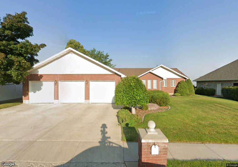
1467 N 1400 E Logan, UT 84341
Hillcrest NeighborhoodEstimated Value: $638,000 - $714,000
5
Beds
3
Baths
3,607
Sq Ft
$186/Sq Ft
Est. Value
About This Home
This home is located at 1467 N 1400 E, Logan, UT 84341 and is currently estimated at $670,674, approximately $185 per square foot. 1467 N 1400 E is a home located in Cache County with nearby schools including Hillcrest Elementary School, Mount Logan Middle School, and Logan High School.
Ownership History
Date
Name
Owned For
Owner Type
Purchase Details
Closed on
Jun 24, 2025
Sold by
Alexander Ray Elliott and Alexander Catherine H
Bought by
Alexander Ray Elliott And Catherine H Elliott and Elliott
Current Estimated Value
Purchase Details
Closed on
Jun 29, 2020
Sold by
Elliott Ray and Elliott Catherine
Bought by
Elliott Alexander Ray and Elliott Catherine H
Purchase Details
Closed on
Feb 29, 2016
Sold by
Elliott A Ray and Elliott Catherine
Bought by
Elliott Alexander Ray and Elliott Elli H
Purchase Details
Closed on
Jan 25, 2007
Sold by
Elliott A Ray
Bought by
Elliott A Ray and Elliott Catherine
Purchase Details
Closed on
Mar 6, 2002
Sold by
Larsen Jane Robinson and Balif Howard P
Bought by
Robinson Frank
Home Financials for this Owner
Home Financials are based on the most recent Mortgage that was taken out on this home.
Original Mortgage
$182,500
Interest Rate
6.94%
Purchase Details
Closed on
Jun 26, 2001
Sold by
Larsen Jane Robinson
Bought by
Balif Howard P and Larsen Jane Robinson
Home Financials for this Owner
Home Financials are based on the most recent Mortgage that was taken out on this home.
Original Mortgage
$337,000
Interest Rate
7.14%
Create a Home Valuation Report for This Property
The Home Valuation Report is an in-depth analysis detailing your home's value as well as a comparison with similar homes in the area
Home Values in the Area
Average Home Value in this Area
Purchase History
| Date | Buyer | Sale Price | Title Company |
|---|---|---|---|
| Alexander Ray Elliott And Catherine H Elliott | -- | Hickman Land Title | |
| Alexander Ray Elliott And Catherine H Elliott | -- | Hickman Land Title | |
| Elliott Alexander Ray | -- | Hickman Land Title Logan | |
| Elliott Alexander Ray | -- | Hickman Land Title Co | |
| Elliott A Ray | -- | Hickman Land Title Company | |
| Elliott A Ray | -- | Hickman Land Title Company | |
| Robinson Frank | -- | Cache Title Company | |
| Balif Howard P | -- | American Secure Title |
Source: Public Records
Mortgage History
| Date | Status | Borrower | Loan Amount |
|---|---|---|---|
| Previous Owner | Robinson Frank | $182,500 | |
| Previous Owner | Balif Howard P | $337,000 |
Source: Public Records
Tax History
| Year | Tax Paid | Tax Assessment Tax Assessment Total Assessment is a certain percentage of the fair market value that is determined by local assessors to be the total taxable value of land and additions on the property. | Land | Improvement |
|---|---|---|---|---|
| 2025 | $3,012 | $389,585 | $0 | $0 |
| 2024 | $3,110 | $389,585 | $0 | $0 |
| 2023 | $3,240 | $386,835 | $0 | $0 |
| 2022 | $2,754 | $307,085 | $0 | $0 |
| 2021 | $2,715 | $467,670 | $105,000 | $362,670 |
| 2020 | $2,568 | $398,101 | $105,000 | $293,101 |
| 2019 | $2,684 | $398,100 | $105,000 | $293,100 |
| 2018 | $2,657 | $359,870 | $105,000 | $254,870 |
| 2017 | $2,287 | $163,735 | $0 | $0 |
| 2016 | $2,371 | $163,735 | $0 | $0 |
| 2015 | $2,187 | $150,865 | $0 | $0 |
| 2014 | $1,977 | $150,865 | $0 | $0 |
| 2013 | -- | $150,865 | $0 | $0 |
Source: Public Records
Map
Nearby Homes
- 1454 N 1400 E
- 1336 E Talmage Ln Unit 38
- 1450 N 1525 E
- 1535 E 1385 N
- 1374 N 1250 E Unit 48
- 1354 N 1250 E Unit 46
- 1341 N 1250 E Unit 41
- 1440 N 1600 E
- 1512 E 1260 N
- 1357 E 1220 N
- 1133 N 1520 E
- 1782 E 1250 N
- 1405 N Aspen Dr
- 1586 N Sharptail Cir
- 1902 E 1500 N
- 1451 N Aspen Dr
- 1475 N Aspen Dr Unit 16
- 1720 N 1850 E
- 1901 Southpointe Ct
- 1100 E 1900 N Unit 10
- 1455 N 1400 E
- 1462 N 1400 E
- 1433 N 1400 E
- 1474 N 1400 E
- 1495 N 1400 E
- 1356 N Amelia Cir Unit 4
- 1415 E 1425 N Unit 16
- 1415 E 1425 N
- 1496 N 1400 E
- 1393 Boxwood Cir
- 1427 E 1425 N
- 1377 E 1400 N
- 1412 E 1425 N
- 10 Bristol Rd
- 15 Bristol Rd
- 1439 E 1425 N
- 26 Bristol Rd
- 1510 N 1350 E
- 1376 E 1400 Cir N
- 1426 E 1425 N
Your Personal Tour Guide
Ask me questions while you tour the home.