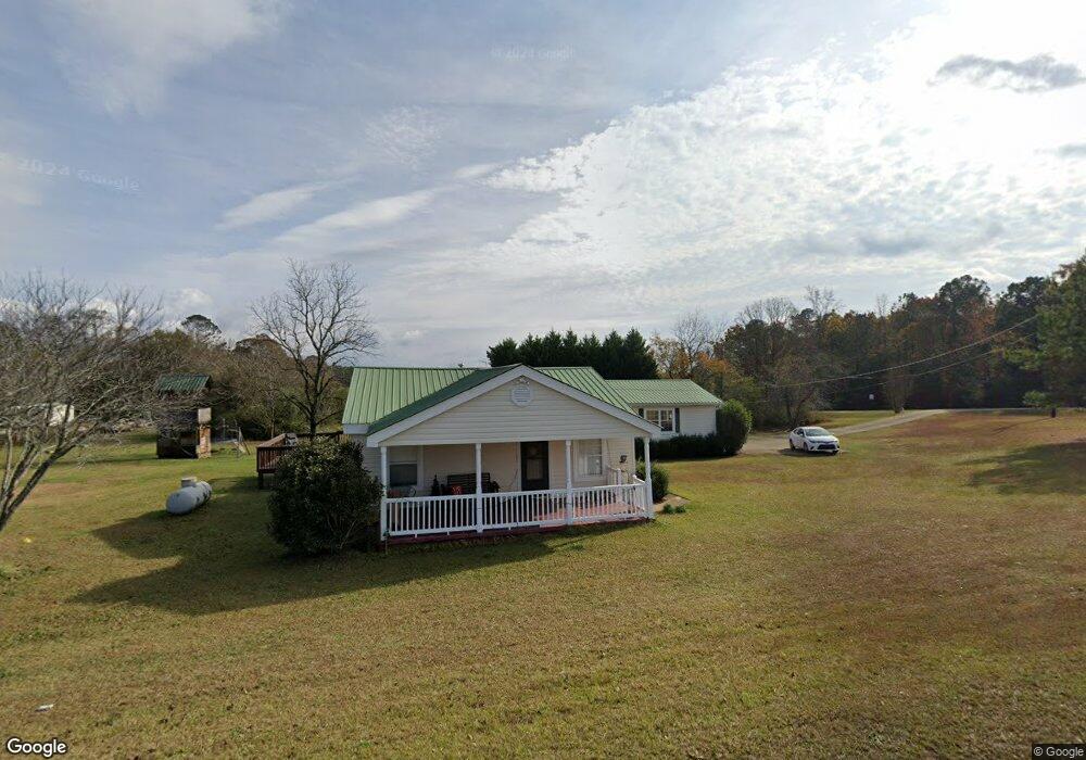
1469 Smokey Rd Lagrange, GA 30241
Estimated Value: $261,000 - $355,000
4
Beds
2
Baths
2,239
Sq Ft
$138/Sq Ft
Est. Value
About This Home
This home is located at 1469 Smokey Rd, Lagrange, GA 30241 and is currently estimated at $309,479, approximately $138 per square foot. 1469 Smokey Rd is a home located in Troup County with nearby schools including Rosemont Elementary School, Whitesville Road Elementary School, and Berta Weathersbee Elementary School.
Ownership History
Date
Name
Owned For
Owner Type
Purchase Details
Closed on
Aug 30, 2002
Sold by
Furgerson Diane and Furgerson Kenneth
Bought by
Conroy Glenn W and Conroy Sonya
Current Estimated Value
Purchase Details
Closed on
Feb 21, 1980
Bought by
Furgerson Diane and Furgerson Kenneth
Purchase Details
Closed on
Jan 2, 1966
Create a Home Valuation Report for This Property
The Home Valuation Report is an in-depth analysis detailing your home's value as well as a comparison with similar homes in the area
Purchase History
| Date | Buyer | Sale Price | Title Company |
|---|---|---|---|
| Conroy Glenn W | $104,000 | -- | |
| Furgerson Diane | $16,500 | -- | |
| -- | -- | -- |
Source: Public Records
Tax History
| Year | Tax Paid | Tax Assessment Tax Assessment Total Assessment is a certain percentage of the fair market value that is determined by local assessors to be the total taxable value of land and additions on the property. | Land | Improvement |
|---|---|---|---|---|
| 2025 | $2,151 | $85,008 | $7,720 | $77,288 |
| 2024 | $1,945 | $73,304 | $7,720 | $65,584 |
| 2023 | $1,400 | $53,336 | $7,720 | $45,616 |
| 2022 | $1,327 | $49,536 | $6,400 | $43,136 |
| 2021 | $1,181 | $41,144 | $6,120 | $35,024 |
| 2020 | $1,181 | $41,144 | $6,120 | $35,024 |
| 2019 | $1,195 | $41,604 | $6,120 | $35,484 |
| 2018 | $1,101 | $38,508 | $6,120 | $32,388 |
| 2017 | $1,101 | $38,508 | $6,120 | $32,388 |
| 2016 | $1,070 | $37,451 | $6,140 | $31,311 |
| 2015 | $1,072 | $37,451 | $6,140 | $31,311 |
| 2014 | $1,024 | $35,804 | $6,140 | $29,664 |
| 2013 | -- | $37,668 | $6,140 | $31,528 |
Source: Public Records
Map
Nearby Homes
- 37.23 ACRES / 0 Smokey Rd
- 158 S Glenn Rd
- 0 Smokey Rd Unit 10570471
- 0 Briley Rd Unit 10582531
- 0 Briley Rd Unit 214353
- 5656 Hamilton Rd
- 5656 Hamilton Rd
- 0 Lower Big Springs Rd Unit 10718109
- 0 Lower Big Springs Rd Unit 26695797
- 950 John Lovelace Rd
- 111 Prestwick Dr
- 830 John Lovelace Rd
- 137 Robertson Rd
- 123 S Smith Rd
- 246 S Smith Rd
- 113 Glenn Eagle Point
- 829 Thrash Rd
- 123 Wexford Dr
- 130 Hamilton Lake Dr
- 417 Tucker Rd
- 651 Briley Rd
- 622 Briley Rd
- 676 Briley Rd
- 1550 Smokey Rd
- 580 Briley Rd
- 718 Briley Rd
- 1388 Smokey Rd
- 1363 Smokey Rd
- 525 Briley Rd
- 1356 Smokey Rd
- 1594 Smokey Rd
- 546 Briley Rd
- 1626 Smokey Rd
- 1620 Smokey Rd
- 430 Briley Rd Unit TRACT 1
- 1665 Smokey Rd
- 1316 Smokey Rd
- 1715 Smokey Rd
- 1650 Smokey Rd
- 1241 Smokey Rd
Your Personal Tour Guide
Ask me questions while you tour the home.