Estimated Value: $231,000 - $304,116
2
Beds
2
Baths
1,500
Sq Ft
$185/Sq Ft
Est. Value
About This Home
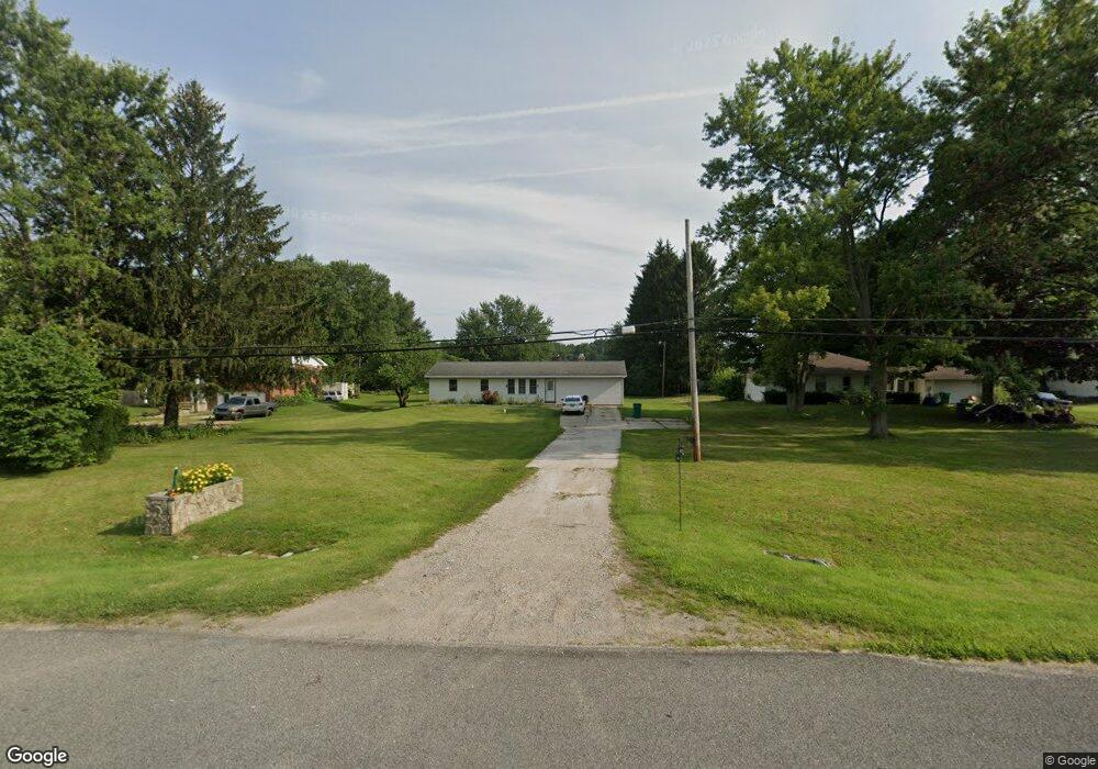
This home is located at 14695 Us Highway 12, Union, MI 49130 and is currently estimated at $277,279, approximately $184 per square foot. 14695 Us Highway 12 is a home located in Cass County with nearby schools including White Pigeon Junior/Senior High School, Central Elementary School, and Kessington Christian School.
Ownership History
Date
Name
Owned For
Owner Type
Purchase Details
Closed on
Sep 22, 2017
Sold by
Minne Paul J and Golf Properties Llc
Bought by
Comadoll Amanda L
Current Estimated Value
Home Financials for this Owner
Home Financials are based on the most recent Mortgage that was taken out on this home.
Original Mortgage
$133,838
Outstanding Balance
$111,764
Interest Rate
3.9%
Mortgage Type
New Conventional
Estimated Equity
$165,515
Purchase Details
Closed on
Sep 2, 2008
Sold by
Federal National Mortgage Association
Bought by
Golf Properties Llc
Purchase Details
Closed on
Sep 26, 2007
Sold by
Mortgage Electronic Registration Systems
Bought by
Federal National Mortgage Association
Purchase Details
Closed on
Apr 11, 2007
Sold by
Buckta Andrew
Bought by
Mortgage Electronic Registration Systems
Create a Home Valuation Report for This Property
The Home Valuation Report is an in-depth analysis detailing your home's value as well as a comparison with similar homes in the area
Home Values in the Area
Average Home Value in this Area
Purchase History
| Date | Buyer | Sale Price | Title Company |
|---|---|---|---|
| Comadoll Amanda L | $130,000 | Title Resource Agency | |
| Golf Properties Llc | $46,500 | Warranty Title Agency Llc | |
| Federal National Mortgage Association | -- | None Available | |
| Mortgage Electronic Registration Systems | $117,394 | None Available |
Source: Public Records
Mortgage History
| Date | Status | Borrower | Loan Amount |
|---|---|---|---|
| Open | Comadoll Amanda L | $133,838 |
Source: Public Records
Tax History Compared to Growth
Tax History
| Year | Tax Paid | Tax Assessment Tax Assessment Total Assessment is a certain percentage of the fair market value that is determined by local assessors to be the total taxable value of land and additions on the property. | Land | Improvement |
|---|---|---|---|---|
| 2025 | $2,549 | $133,400 | $133,400 | $0 |
| 2024 | $698 | $115,900 | $115,900 | $0 |
| 2023 | $665 | $93,000 | $0 | $0 |
| 2022 | $634 | $75,500 | $0 | $0 |
| 2021 | $2,748 | $71,800 | $0 | $0 |
| 2020 | $2,677 | $68,100 | $0 | $0 |
| 2019 | $2,662 | $63,000 | $0 | $0 |
| 2018 | $583 | $54,300 | $0 | $0 |
| 2017 | $583 | $60,600 | $0 | $0 |
| 2016 | $577 | $56,200 | $0 | $0 |
| 2015 | -- | $53,600 | $0 | $0 |
| 2011 | -- | $56,900 | $0 | $0 |
Source: Public Records
Map
Nearby Homes
- 69588 Baldwin Prairie Rd
- 69692 Oak St
- 5 Pickeral Ave
- 6 Pickeral Ave
- 7 Pickeral Ave
- 4 Pike Ln
- 3 Pike Ln
- 2 Pike Ln
- 1 Pike Ln
- 0 Parcel B Sunset Blvd
- 0 Parcel A Sunset Blvd
- 69909 Sunset Blvd
- 70855 Hollywood Shores
- 69951 Sunset Blvd
- 70830 Baldwin Landing Dr
- 70877 Sunset Blvd
- 69639 Shady Ln
- 70855 Wayne St
- 50764 Stella Ct
- 50774 Teall Rd
- 14695 U S 12
- 14676 Us Highway 12
- 14676 U S 12
- 14711 Us Highway 12
- 14711 U S 12
- 14744 Us Highway 12
- 14660 Us Highway 12
- 14640 U S 12
- 14764 Us Highway 12
- 14764 U S 12
- 14610 Us Highway 12
- 14610 U S 12
- 14741 Us Highway 12
- 14790 U S 12
- 14765 Us Highway 12
- 14765 U S 12
- 14600 Us Highway 12
- 14790 Us Highway 12
- 16944 U S 12
- 15910 U S 12