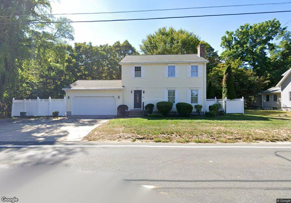
147 Cayenne St West Springfield, MA 01089
Estimated Value: $407,000 - $542,000
4
Beds
2
Baths
1,560
Sq Ft
$288/Sq Ft
Est. Value
About This Home
This home is located at 147 Cayenne St, West Springfield, MA 01089 and is currently estimated at $449,015, approximately $287 per square foot. 147 Cayenne St is a home located in Hampden County with nearby schools including West Springfield High School, Hampden Charter School of Science West, and St Thomas The Apostle School.
Ownership History
Date
Name
Owned For
Owner Type
Purchase Details
Closed on
Apr 18, 2012
Sold by
Jones Candice A Est and Palmer
Bought by
Palmer James
Current Estimated Value
Purchase Details
Closed on
Jan 31, 1996
Sold by
Fitzgerald John G
Bought by
Jones Candice A
Home Financials for this Owner
Home Financials are based on the most recent Mortgage that was taken out on this home.
Original Mortgage
$10,000
Interest Rate
7.02%
Purchase Details
Closed on
Sep 26, 1994
Sold by
Rafay Helen and Storey Eva M
Bought by
Fitzgerald John G
Create a Home Valuation Report for This Property
The Home Valuation Report is an in-depth analysis detailing your home's value as well as a comparison with similar homes in the area
Home Values in the Area
Average Home Value in this Area
Purchase History
| Date | Buyer | Sale Price | Title Company |
|---|---|---|---|
| Palmer James | -- | -- | |
| Palmer James | -- | -- | |
| Palmer James | -- | -- | |
| Jones Candice A | $122,900 | -- | |
| Jones Candice A | $122,900 | -- | |
| Fitzgerald John G | $13,000 | -- |
Source: Public Records
Mortgage History
| Date | Status | Borrower | Loan Amount |
|---|---|---|---|
| Previous Owner | Fitzgerald John G | $10,000 | |
| Previous Owner | Fitzgerald John G | $70,000 |
Source: Public Records
Tax History
| Year | Tax Paid | Tax Assessment Tax Assessment Total Assessment is a certain percentage of the fair market value that is determined by local assessors to be the total taxable value of land and additions on the property. | Land | Improvement |
|---|---|---|---|---|
| 2025 | $5,044 | $339,200 | $122,900 | $216,300 |
| 2024 | $4,603 | $310,800 | $98,700 | $212,100 |
| 2023 | $4,399 | $283,100 | $98,700 | $184,400 |
| 2022 | $3,741 | $237,400 | $89,700 | $147,700 |
| 2021 | $3,691 | $218,400 | $85,500 | $132,900 |
| 2020 | $3,661 | $215,500 | $85,500 | $130,000 |
| 2019 | $3,655 | $215,500 | $85,500 | $130,000 |
| 2018 | $3,674 | $215,500 | $85,500 | $130,000 |
| 2017 | $3,674 | $215,500 | $85,500 | $130,000 |
| 2016 | $3,680 | $216,600 | $82,500 | $134,100 |
| 2015 | $3,605 | $212,200 | $80,700 | $131,500 |
| 2014 | $883 | $212,200 | $80,700 | $131,500 |
Source: Public Records
Map
Nearby Homes
- 36 Shady Brook
- 2 Windpath E
- 404 Brush Hill Ave
- 0 Ahiska Rd Unit 73477754
- 80 Brush Hill Ave Unit 61
- 791 Morgan Rd
- 917 Elm St
- 132 Lincoln St
- 51-53 Abbe Ave
- 11 Annie's Way
- 69 Beston St
- 13 Beston St
- 27 Abbey St
- 20-22 Gay Terrace
- 0 School St
- 61 Clarence St
- 21 Depot St
- 240 Morton St
- 224 Riverdale St
- 248 Hampden St
- 163 Cayenne St
- 152 Cayenne St
- 129 Cayenne St
- 138 Cayenne St
- 168 Cayenne St
- 176 Cayenne St
- 124 Cayenne St
- 22 Apple Ridge Rd
- 193 Cayenne St
- 116 Cayenne St
- 33 Apple Ridge Rd
- 33 Skyline Dr
- 194 Cayenne St
- 105 Cayenne St
- 203 Cayenne St
- 108 Cayenne St
- 43 Skyline Dr
- 97 Cayenne St
- 47 Apple Ridge Rd
- 248 Morgan Rd
Your Personal Tour Guide
Ask me questions while you tour the home.