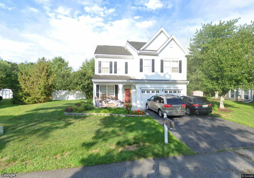
147 E Mourning Dove Way Galloway, NJ 08205
Estimated Value: $430,588 - $493,000
--
Bed
--
Bath
2,462
Sq Ft
$186/Sq Ft
Est. Value
About This Home
This home is located at 147 E Mourning Dove Way, Galloway, NJ 08205 and is currently estimated at $458,147, approximately $186 per square foot. 147 E Mourning Dove Way is a home located in Atlantic County with nearby schools including Absegami High School, Cedar Creek High School, and Oakcrest High School.
Ownership History
Date
Name
Owned For
Owner Type
Purchase Details
Closed on
Jun 28, 1996
Sold by
Mcmenamin Marianne and Tremont Marianne
Bought by
Do Dung and Do Thuy
Current Estimated Value
Home Financials for this Owner
Home Financials are based on the most recent Mortgage that was taken out on this home.
Original Mortgage
$118,800
Outstanding Balance
$8,391
Interest Rate
7.98%
Estimated Equity
$449,756
Purchase Details
Closed on
Oct 20, 1995
Sold by
Mcmenamin Daniel J and Tremont Marianne
Bought by
Mcmenamin Marianne and Tremont Marianne
Create a Home Valuation Report for This Property
The Home Valuation Report is an in-depth analysis detailing your home's value as well as a comparison with similar homes in the area
Home Values in the Area
Average Home Value in this Area
Purchase History
| Date | Buyer | Sale Price | Title Company |
|---|---|---|---|
| Do Dung | $148,500 | The Title Company | |
| Mcmenamin Marianne | -- | -- |
Source: Public Records
Mortgage History
| Date | Status | Borrower | Loan Amount |
|---|---|---|---|
| Open | Do Dung | $118,800 |
Source: Public Records
Tax History Compared to Growth
Tax History
| Year | Tax Paid | Tax Assessment Tax Assessment Total Assessment is a certain percentage of the fair market value that is determined by local assessors to be the total taxable value of land and additions on the property. | Land | Improvement |
|---|---|---|---|---|
| 2025 | $6,986 | $209,300 | $41,000 | $168,300 |
| 2024 | $6,986 | $209,300 | $41,000 | $168,300 |
| 2023 | $6,721 | $209,300 | $41,000 | $168,300 |
| 2022 | $6,721 | $209,300 | $41,000 | $168,300 |
| 2021 | $6,587 | $209,300 | $41,000 | $168,300 |
| 2020 | $6,482 | $209,300 | $41,000 | $168,300 |
| 2019 | $6,363 | $209,300 | $41,000 | $168,300 |
| 2018 | $6,453 | $209,300 | $41,000 | $168,300 |
| 2017 | $6,453 | $209,300 | $41,000 | $168,300 |
| 2016 | $6,396 | $209,300 | $41,000 | $168,300 |
| 2015 | $6,525 | $214,500 | $41,000 | $173,500 |
| 2014 | $6,308 | $214,500 | $41,000 | $173,500 |
Source: Public Records
Map
Nearby Homes
- 59 Shawnee Place Unit 9E
- 57 Shawnee Place
- 80 Club Place Unit B2
- 152 Club Place Unit 26B
- 41 Seneca Dr
- 41 Seneca Dr Unit 1062
- 126 Club Place
- 69 Arapaho Place
- 25 Seneca Dr Unit 25
- 9 Seneca Dr
- 24 Iroquois Dr Unit 24
- 103 Federal Ct Unit H1
- 213 Patriots Ct Unit 29B
- 127 Iroquois Dr Unit F1
- 181 Rumson Dr Unit 1084
- 69 Iroquois Dr
- 69 Iroquois Dr Unit 15
- 37 Colonial Ct Unit H1
- 137 Liberty Ct Unit 2401
- 22 Colonial Ct
- 145 E Mourning Dove Way
- 149 E Mourning Dove Way
- 143 E Mourning Dove Way
- 151 E Mourning Dove Way
- 141 E Mourning Dove Way
- 153 E Mourning Dove Way
- 165 E Nightingale Way
- 35 S Canary Way
- 33 S Canary Way
- 155 E Mourning Dove Way
- 144 E Mourning Dove Way
- 31 S Canary Way
- 163 E Nightingale Way
- 157 E Mourning Dove Way
- 142 E Mourning Dove Way
- 29 S Canary Way
- 27 Club Place
- 161 E Nightingale Way
- 33 Club Place
- 29 Club Place