
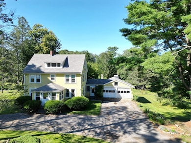
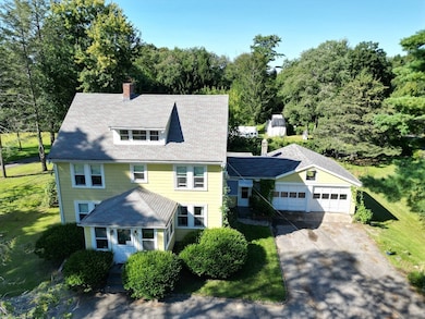
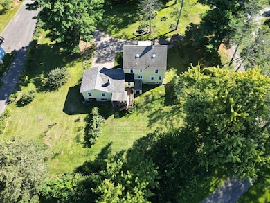
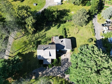
147 Linebrook Rd Ipswich, MA 01938
Estimated payment $4,032/month
Highlights
- 0.69 Acre Lot
- Open Floorplan
- Living Room with Fireplace
- Ipswich High School Rated A-
- Fruit Trees
- Wood Flooring
About This Home
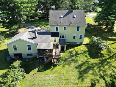
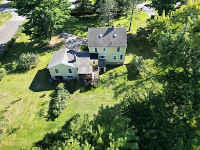
Discover the potential of 147 Linebrook Road in beautiful Ipswich —ideal for contractors and buyers seeking sweat equity to transform this charming home set on a sprawling .69-acre lot. With 4 bedrooms and 2 bathrooms, this 1,796 square foot residence features hardwood floors, 2 fireplaces, bonus room/breezeway, large basement for loads of storage, and a 3rd floor walk-up attic offers expansive possibilities. . The large kitchen with an open concept to the dining room is perfect for gatherings. Outdoors, the expansive backyard is a gardener's dream, featuring fruit trees and lush fruit and vegetable patches. While the home needs renovation, it presents an excellent opportunity to apply personal touches and creativity. Embrace the opportunity to transform this residence into your personalized haven today! To the best of sellers knowledge: Heat is approx 10 years old, hardwoods under carpeted areas
Home Details
Home Type
- Single Family
Est. Annual Taxes
- $7,511
Year Built
- Built in 1940
Lot Details
- 0.69 Acre Lot
- Level Lot
- Fruit Trees
- Wooded Lot
- Garden
- Property is zoned RRA
Parking
- 2 Car Attached Garage
- Driveway
- Open Parking
- Off-Street Parking
Home Design
- Farmhouse Style Home
- Stone Foundation
- Shingle Roof
Interior Spaces
- 1,796 Sq Ft Home
- Open Floorplan
- Light Fixtures
- Window Screens
- French Doors
- Living Room with Fireplace
- 2 Fireplaces
- Bonus Room
- Wood Flooring
Bedrooms and Bathrooms
- 4 Bedrooms
- Primary bedroom located on second floor
- 2 Full Bathrooms
- Soaking Tub
Unfinished Basement
- Walk-Out Basement
- Interior Basement Entry
- Laundry in Basement
Outdoor Features
- Bulkhead
- Breezeway
- Rain Gutters
Utilities
- Window Unit Cooling System
- Central Heating
- 1 Heating Zone
- Heating System Uses Oil
- 200+ Amp Service
- Gas Water Heater
- Private Sewer
Community Details
- No Home Owners Association
Listing and Financial Details
- Assessor Parcel Number 1954621
Map
Home Values in the Area
Average Home Value in this Area
Tax History
| Year | Tax Paid | Tax Assessment Tax Assessment Total Assessment is a certain percentage of the fair market value that is determined by local assessors to be the total taxable value of land and additions on the property. | Land | Improvement |
|---|---|---|---|---|
| 2025 | $7,511 | $673,600 | $323,400 | $350,200 |
| 2024 | $7,048 | $619,300 | $323,800 | $295,500 |
| 2023 | $6,557 | $536,100 | $276,400 | $259,700 |
| 2022 | $6,352 | $493,900 | $260,600 | $233,300 |
| 2021 | $6,256 | $473,200 | $256,700 | $216,500 |
| 2020 | $6,452 | $460,200 | $262,600 | $197,600 |
| 2019 | $6,209 | $440,700 | $250,800 | $189,900 |
| 2018 | $6,079 | $426,900 | $237,000 | $189,900 |
| 2017 | $5,781 | $407,400 | $225,100 | $182,300 |
| 2016 | $5,196 | $349,900 | $189,600 | $160,300 |
| 2015 | $4,673 | $345,900 | $185,600 | $160,300 |
Property History
| Date | Event | Price | List to Sale | Price per Sq Ft |
|---|---|---|---|---|
| 11/18/2025 11/18/25 | Pending | -- | -- | -- |
| 10/30/2025 10/30/25 | Price Changed | $645,000 | -4.4% | $359 / Sq Ft |
| 10/18/2025 10/18/25 | For Sale | $675,000 | -- | $376 / Sq Ft |
Purchase History
| Date | Type | Sale Price | Title Company |
|---|---|---|---|
| Deed | -- | None Available | |
| Deed | -- | None Available | |
| Deed | -- | None Available | |
| Deed | -- | -- |
Mortgage History
| Date | Status | Loan Amount | Loan Type |
|---|---|---|---|
| Previous Owner | $55,000 | No Value Available | |
| Previous Owner | $130,000 | No Value Available | |
| Previous Owner | $55,000 | No Value Available | |
| Previous Owner | $60,000 | No Value Available |
Source: MLS Property Information Network (MLS PIN)
MLS Number: 73445220
APN: IPSW-000029D-000027
Disclaimer: Certain information contained herein is derived from information provided by parties other than Homes.com. All information provided is deemed reliable, but is not guaranteed to be accurate and should be independently verified.
![]() The property listing data and information, or the Images, set forth herein were provided to MLS Property Information Network, Inc. from third party sources, including sellers, lessors and public records, and were compiled by MLS Property Information Network, Inc. The property listing data and information, and the Images, are for the personal, non-commercial use of consumers having a good faith interest in purchasing or leasing listed properties of the type displayed to them and may not be used for any purpose other than to identify prospective properties which such consumers may have a good faith interest in purchasing or leasing. MLS Property Information Network, Inc. and its subscribers disclaim any and all representations and warranties as to the accuracy of the property listing data and information, or as to the accuracy of any of the Images, set forth herein.
The property listing data and information, or the Images, set forth herein were provided to MLS Property Information Network, Inc. from third party sources, including sellers, lessors and public records, and were compiled by MLS Property Information Network, Inc. The property listing data and information, and the Images, are for the personal, non-commercial use of consumers having a good faith interest in purchasing or leasing listed properties of the type displayed to them and may not be used for any purpose other than to identify prospective properties which such consumers may have a good faith interest in purchasing or leasing. MLS Property Information Network, Inc. and its subscribers disclaim any and all representations and warranties as to the accuracy of the property listing data and information, or as to the accuracy of any of the Images, set forth herein.
- 4 Sheppards Way
- 98 Linebrook Rd
- 45 Pineswamp Rd
- 64 Linebrook Rd
- 10 Olde Ipswich Way Unit E
- 128 High St Unit 4
- 38 Kimball Ave Unit 5
- 4 Dornell Rd
- 11 Heard Dr
- 21 Brownville Ave
- 11 Washington St
- 11 Washington St Unit 5
- 11 Washington St Unit 10
- 11 Washington St Unit 4
- 11 Washington St Unit 12
- 11 Washington St Unit Nine
- 6 Mayfair Ct
- 3 Soffron Ln Unit 2
- 24 River Point Dr Unit 6
- 50-56 Market St
