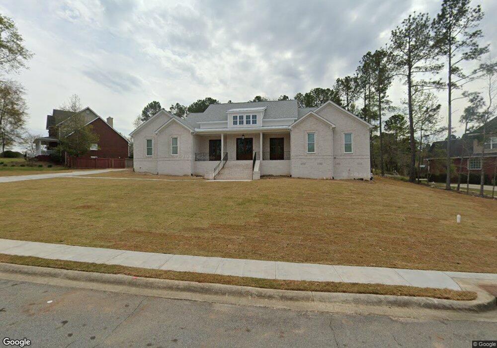
147 Mcclain Cir Macon, GA 31216
Estimated Value: $459,000 - $522,732
4
Beds
4
Baths
2,986
Sq Ft
$165/Sq Ft
Est. Value
About This Home
This home is located at 147 Mcclain Cir, Macon, GA 31216 and is currently estimated at $493,683, approximately $165 per square foot. 147 Mcclain Cir is a home with nearby schools including Porter Elementary School, Rutland Middle School, and Rutland High School.
Ownership History
Date
Name
Owned For
Owner Type
Purchase Details
Closed on
Jan 12, 2018
Sold by
Stafford Shawn and Stafford Dorothy
Bought by
Stafford Walter Lavar and Stafford Yoshonda Williams
Current Estimated Value
Home Financials for this Owner
Home Financials are based on the most recent Mortgage that was taken out on this home.
Original Mortgage
$15,000
Interest Rate
3.9%
Mortgage Type
New Conventional
Purchase Details
Closed on
Jan 13, 2006
Sold by
Wesley Walker Construction Co
Bought by
Stafford Shawn and Stafford Dorothy
Create a Home Valuation Report for This Property
The Home Valuation Report is an in-depth analysis detailing your home's value as well as a comparison with similar homes in the area
Purchase History
| Date | Buyer | Sale Price | Title Company |
|---|---|---|---|
| Stafford Walter Lavar | $20,000 | None Available | |
| Stafford Shawn | $43,900 | None Available |
Source: Public Records
Mortgage History
| Date | Status | Borrower | Loan Amount |
|---|---|---|---|
| Closed | Stafford Walter Lavar | $15,000 |
Source: Public Records
Tax History
| Year | Tax Paid | Tax Assessment Tax Assessment Total Assessment is a certain percentage of the fair market value that is determined by local assessors to be the total taxable value of land and additions on the property. | Land | Improvement |
|---|---|---|---|---|
| 2025 | $5,180 | $217,783 | $14,000 | $203,783 |
| 2024 | $4,860 | $198,375 | $14,000 | $184,375 |
| 2023 | $5,669 | $198,375 | $14,000 | $184,375 |
| 2022 | $6,630 | $191,495 | $14,000 | $177,495 |
| 2021 | $426 | $11,214 | $11,214 | $0 |
| 2020 | $245 | $6,300 | $6,300 | $0 |
| 2019 | $247 | $6,300 | $6,300 | $0 |
| 2018 | $378 | $6,300 | $6,300 | $0 |
| 2017 | $236 | $6,300 | $6,300 | $0 |
| 2016 | $242 | $7,000 | $7,000 | $0 |
| 2015 | $343 | $7,000 | $7,000 | $0 |
| 2014 | $114 | $7,000 | $7,000 | $0 |
Source: Public Records
Map
Nearby Homes
- 171 Mcclain Cir
- 130 Mcclain Cir
- 426 Southern Oaks Dr
- 428 Bellerive Trace
- 444 Southern Oaks Dr
- 448 Southern Oaks Dr Unit LOT 30
- 450 Southern Oaks Dr
- 5514 Bankston Lake Rd
- 5524 Bankston Lake Rd
- 363 Eagle Ridge Rd
- 452 Southern Oaks Dr
- 456 Southern Oaks Dr
- 456 Southern Oaks Dr Unit 33
- 219 Trenton Terrace
- 458 Southern Oaks Dr
- 463 Southern Oaks Dr Unit LOT 35B
- 5250 Tinker Dr
- 620 Britton Way
- 109 Oakview Club Dr
- 3636 Bonanza Dr
- 145 Mcclain Cir
- 150 Mcclain Cir
- 154 Mcclain Cir
- 153 Mcclain Cir Unit 35
- 153 Mcclain Cir
- 148 Mcclain Cir
- 158 Mcclain Cir
- 143 Mcclain Cir
- 160 Mcclain Cir
- 146 Mcclain Cir
- 159 Mcclain Cir
- 141 Mcclain Cir
- 144 Mcclain Cir
- 161 Mcclain Cir
- 142 Mcclain Cir
- 409 Bellerive Trace Unit 19
- 409 Bellerive Trace
- 401 Bellerive Trace
- 405 Bellerive Trace
- 401 Bellerice Trace
Your Personal Tour Guide
Ask me questions while you tour the home.