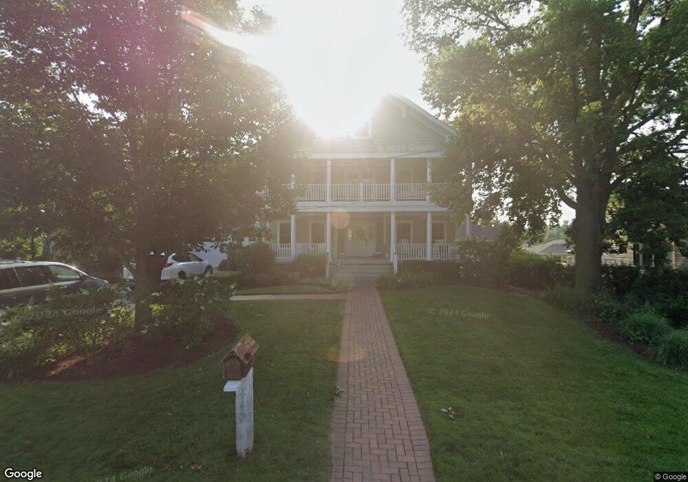
147 S Locust St Frankfort, IL 60423
North Frankfort NeighborhoodEstimated Value: $558,000 - $840,000
4
Beds
3
Baths
3,100
Sq Ft
$230/Sq Ft
Est. Value
About This Home
This home is located at 147 S Locust St, Frankfort, IL 60423 and is currently estimated at $714,005, approximately $230 per square foot. 147 S Locust St is a home located in Will County with nearby schools including Grand Prairie Elementary School, Chelsea Intermediate School, and Hickory Creek Middle School.
Ownership History
Date
Name
Owned For
Owner Type
Purchase Details
Closed on
Aug 30, 2007
Sold by
Gander Construction Inc
Bought by
Delage Saul
Current Estimated Value
Home Financials for this Owner
Home Financials are based on the most recent Mortgage that was taken out on this home.
Original Mortgage
$602,792
Outstanding Balance
$370,348
Interest Rate
6%
Mortgage Type
New Conventional
Estimated Equity
$343,657
Purchase Details
Closed on
Nov 9, 2006
Sold by
State Bank Of Countryside
Bought by
Gander Construction Inc
Home Financials for this Owner
Home Financials are based on the most recent Mortgage that was taken out on this home.
Original Mortgage
$149,600
Interest Rate
8.25%
Mortgage Type
Purchase Money Mortgage
Purchase Details
Closed on
Sep 22, 2005
Sold by
Schomburg William R and Schomburg Alice Y
Bought by
State Bank Of Countryside and Trust #89-622
Create a Home Valuation Report for This Property
The Home Valuation Report is an in-depth analysis detailing your home's value as well as a comparison with similar homes in the area
Home Values in the Area
Average Home Value in this Area
Purchase History
| Date | Buyer | Sale Price | Title Company |
|---|---|---|---|
| Delage Saul | $753,500 | Chicago Title Insurance Co | |
| Gander Construction Inc | $187,000 | Atg | |
| State Bank Of Countryside | $150,500 | Fatic |
Source: Public Records
Mortgage History
| Date | Status | Borrower | Loan Amount |
|---|---|---|---|
| Open | Delage Saul | $602,792 | |
| Previous Owner | Gander Construction Inc | $149,600 |
Source: Public Records
Tax History Compared to Growth
Tax History
| Year | Tax Paid | Tax Assessment Tax Assessment Total Assessment is a certain percentage of the fair market value that is determined by local assessors to be the total taxable value of land and additions on the property. | Land | Improvement |
|---|---|---|---|---|
| 2024 | $20,087 | $261,524 | $72,731 | $188,793 |
| 2023 | $20,087 | $233,566 | $64,956 | $168,610 |
| 2022 | $17,545 | $212,739 | $59,164 | $153,575 |
| 2021 | $16,566 | $199,026 | $55,350 | $143,676 |
| 2020 | $16,164 | $193,417 | $53,790 | $139,627 |
| 2019 | $15,653 | $188,240 | $52,350 | $135,890 |
| 2018 | $15,385 | $182,828 | $50,845 | $131,983 |
| 2017 | $15,382 | $178,560 | $49,658 | $128,902 |
| 2016 | $15,033 | $172,439 | $47,956 | $124,483 |
| 2015 | $14,674 | $166,366 | $46,267 | $120,099 |
| 2014 | $14,674 | $165,209 | $45,945 | $119,264 |
| 2013 | $14,674 | $167,351 | $46,541 | $120,810 |
Source: Public Records
Map
Nearby Homes
- 337 Sherlock St
- 481 Pleasant Hill Rd
- 119 Pleasant Hill Ct
- 9748 Folkers Dr
- Lot 3 Town Center Dr
- 9736 Folkers Dr
- 9772 Folkers Dr
- 267 Center Rd
- 9724 Folkers Dr
- 701 Brookside Ln
- 130 Evergreen Dr
- 425 Cottonwood Rd
- 9815 W Laraway Rd
- 10652 Lexington Ct
- 21160 S 93rd Ave
- 21213 S 93rd Ave
- 21203 S 93rd Ave
- 935 N Butternut Cir
- 725 Birchwood Rd
- 10785 Ashford Ave