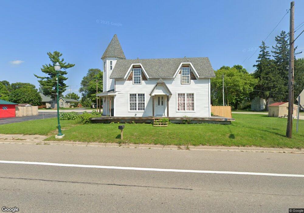
147 S State Rd Otisville, MI 48463
Estimated Value: $76,009 - $173,000
--
Bed
--
Bath
2,387
Sq Ft
$60/Sq Ft
Est. Value
About This Home
This home is located at 147 S State Rd, Otisville, MI 48463 and is currently estimated at $143,002, approximately $59 per square foot. 147 S State Rd is a home located in Genesee County with nearby schools including Columbiaville Elementary School, Otisville Elementary School, and Lakeville Middle School.
Ownership History
Date
Name
Owned For
Owner Type
Purchase Details
Closed on
Sep 30, 2002
Sold by
Shanks Charles A and Shanks Susan M
Bought by
Piet Rodney
Current Estimated Value
Home Financials for this Owner
Home Financials are based on the most recent Mortgage that was taken out on this home.
Original Mortgage
$70,500
Outstanding Balance
$35,257
Interest Rate
9%
Mortgage Type
Seller Take Back
Estimated Equity
$107,745
Purchase Details
Closed on
May 21, 2002
Sold by
Hall James R and Hall Judith Ann
Bought by
Shanks Charles A
Create a Home Valuation Report for This Property
The Home Valuation Report is an in-depth analysis detailing your home's value as well as a comparison with similar homes in the area
Home Values in the Area
Average Home Value in this Area
Purchase History
| Date | Buyer | Sale Price | Title Company |
|---|---|---|---|
| Piet Rodney | $82,000 | -- | |
| Shanks Charles A | $60,000 | -- |
Source: Public Records
Mortgage History
| Date | Status | Borrower | Loan Amount |
|---|---|---|---|
| Open | Piet Rodney | $70,500 |
Source: Public Records
Tax History Compared to Growth
Tax History
| Year | Tax Paid | Tax Assessment Tax Assessment Total Assessment is a certain percentage of the fair market value that is determined by local assessors to be the total taxable value of land and additions on the property. | Land | Improvement |
|---|---|---|---|---|
| 2025 | $1,450 | $32,400 | $0 | $0 |
| 2024 | $775 | $31,300 | $0 | $0 |
| 2023 | $739 | $28,800 | $0 | $0 |
| 2022 | $688 | $26,100 | $0 | $0 |
| 2021 | $1,680 | $25,900 | $0 | $0 |
| 2020 | $679 | $25,600 | $0 | $0 |
| 2019 | $667 | $24,000 | $0 | $0 |
| 2018 | $1,273 | $21,500 | $0 | $0 |
| 2017 | $1,239 | $21,100 | $0 | $0 |
| 2016 | $1,243 | $19,300 | $0 | $0 |
| 2015 | $845 | $18,000 | $0 | $0 |
| 2014 | $206 | $18,000 | $0 | $0 |
| 2012 | -- | $18,000 | $18,000 | $0 |
Source: Public Records
Map
Nearby Homes
- 205 Grove St
- 315 Orchard Cove Dr
- 311 Peach Blossom Ct
- 105 Center St
- 453 S State Rd
- 11154 Gale Rd
- 10374 Wilson Rd
- 9417 N State Rd
- 9306 Dodge Rd
- 9196 N Gale Rd
- 11056 N Irish Rd
- 12441 Irish Rd
- 9467 E Frances Rd
- 11219 Dodge Rd
- V/L N Irish Rd
- 10347 Irish Rd
- 00 Farrand Rd
- 0 Farrand Rd Unit 50166883
- 12185 Irish Rd
- 8136 Farrand Rd
- 147 S State Rd
- 161 S State Rd
- 139 S State Rd
- 152 S State Rd
- 160 S State Rd
- 144 S State Rd
- 205 S State Rd
- PAR D Washburn Rd
- 134 S State Rd
- 131 Orchard St
- 128 S State Rd
- 211 S State Rd
- 159 Park St
- 153 S Jefferson St
- 127 Park St
- 120 S State Rd
- 225 S Jefferson St
- 119 Orchard St
- 143 S Jefferson St
- 147 S Jefferson St