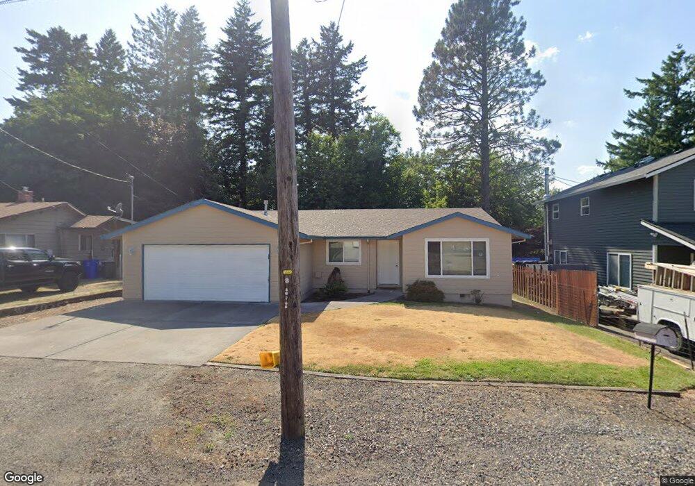
147 SE Linden Ave Gresham, OR 97080
Historic Southeast NeighborhoodEstimated Value: $408,000 - $420,286
3
Beds
2
Baths
1,252
Sq Ft
$332/Sq Ft
Est. Value
About This Home
This home is located at 147 SE Linden Ave, Gresham, OR 97080 and is currently estimated at $415,822, approximately $332 per square foot. 147 SE Linden Ave is a home located in Multnomah County with nearby schools including East Gresham Elementary School, Dexter McCarty Middle School, and Gresham High School.
Ownership History
Date
Name
Owned For
Owner Type
Purchase Details
Closed on
Dec 26, 2000
Sold by
Harry Daniel W
Bought by
Benting Merlyn R
Current Estimated Value
Home Financials for this Owner
Home Financials are based on the most recent Mortgage that was taken out on this home.
Original Mortgage
$102,000
Outstanding Balance
$37,129
Interest Rate
7.71%
Mortgage Type
Purchase Money Mortgage
Estimated Equity
$378,693
Create a Home Valuation Report for This Property
The Home Valuation Report is an in-depth analysis detailing your home's value as well as a comparison with similar homes in the area
Home Values in the Area
Average Home Value in this Area
Purchase History
| Date | Buyer | Sale Price | Title Company |
|---|---|---|---|
| Benting Merlyn R | $136,000 | Fidelity National Title Co |
Source: Public Records
Mortgage History
| Date | Status | Borrower | Loan Amount |
|---|---|---|---|
| Open | Benting Merlyn R | $102,000 |
Source: Public Records
Tax History
| Year | Tax Paid | Tax Assessment Tax Assessment Total Assessment is a certain percentage of the fair market value that is determined by local assessors to be the total taxable value of land and additions on the property. | Land | Improvement |
|---|---|---|---|---|
| 2025 | $3,988 | $195,970 | -- | -- |
| 2024 | $3,818 | $190,270 | -- | -- |
| 2023 | $3,478 | $184,730 | $0 | $0 |
| 2022 | $3,381 | $179,350 | $0 | $0 |
| 2021 | $3,296 | $174,130 | $0 | $0 |
| 2020 | $3,101 | $169,060 | $0 | $0 |
| 2019 | $3,020 | $164,140 | $0 | $0 |
| 2018 | $2,879 | $159,360 | $0 | $0 |
| 2017 | $2,762 | $154,720 | $0 | $0 |
| 2016 | $2,436 | $150,220 | $0 | $0 |
Source: Public Records
Map
Nearby Homes
- 329 SE Linden Ct
- 234 NE Cleveland Ave
- 415 SE Roberts Ave
- 491 NE Elliott Ave
- 4764 SE 2nd St
- 4667 SE 2nd St
- 318 NE Roberts Ave Unit 308
- 318 NE Roberts Ave Unit 203
- 210 NE 5th St
- 0 NE 6th St
- 1700 SE 4th St
- 0 NE 5th St
- 660 NE 9th St
- 894 NE Linden Ave
- 450 SE Hogan Rd
- 824 NW Mignonette Ave
- 55 SW Lovhar Dr
- 511 SE 15th St
- 1414 SE Beech Place
- 900 NE Francis Ave Unit 29
- 155 SE Linden Ave
- 123 SE Linden Ave Unit 133
- 105 SE Linden Ave
- 185 SE Linden Ave
- 150 SE Linden Ave
- 790 SE 1st St
- 116 SE Elliott Ave
- 122 SE Elliott Ave
- 651 SE 1st St
- 124 SE Elliott Ave
- 190 SE Linden Ave
- 100 SE Elliott Ave
- 85 SE Linden Ave
- 200 SE Elliott Ave Unit 214
- 200 SE Linden Ct
- 48 SE Elliott Ave
- 687 SE 1st St
- 205 SE Linden Ct
- 235 SE Juniper Ave
- 790 Powell Blvd
Your Personal Tour Guide
Ask me questions while you tour the home.