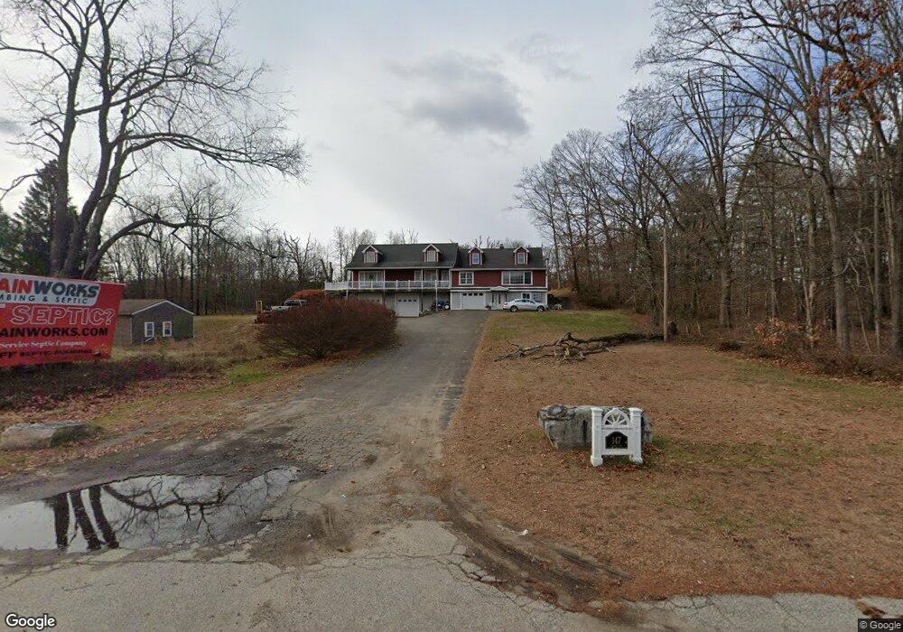
147 Stafford Rd Mansfield Center, CT 06250
Estimated Value: $375,000 - $459,000
4
Beds
3
Baths
3,172
Sq Ft
$128/Sq Ft
Est. Value
About This Home
This home is located at 147 Stafford Rd, Mansfield Center, CT 06250 and is currently estimated at $406,828, approximately $128 per square foot. 147 Stafford Rd is a home located in Tolland County with nearby schools including Annie E. Vinton School, Mansfield Elementary School, and E.O. Smith High School.
Ownership History
Date
Name
Owned For
Owner Type
Purchase Details
Closed on
Mar 3, 2008
Sold by
Est Cornell Craig B and Cornell Robert N
Bought by
Cornell Keli L and Rice Daniel H
Current Estimated Value
Home Financials for this Owner
Home Financials are based on the most recent Mortgage that was taken out on this home.
Original Mortgage
$177,800
Outstanding Balance
$111,123
Interest Rate
5.8%
Mortgage Type
Commercial
Estimated Equity
$295,705
Create a Home Valuation Report for This Property
The Home Valuation Report is an in-depth analysis detailing your home's value as well as a comparison with similar homes in the area
Home Values in the Area
Average Home Value in this Area
Purchase History
| Date | Buyer | Sale Price | Title Company |
|---|---|---|---|
| Cornell Keli L | $177,800 | -- | |
| Cornell Keli L | $177,800 | -- |
Source: Public Records
Mortgage History
| Date | Status | Borrower | Loan Amount |
|---|---|---|---|
| Closed | Cornell Keli L | $25,000 | |
| Open | Cornell Keli L | $177,800 | |
| Closed | Cornell Keli L | $177,800 |
Source: Public Records
Tax History Compared to Growth
Tax History
| Year | Tax Paid | Tax Assessment Tax Assessment Total Assessment is a certain percentage of the fair market value that is determined by local assessors to be the total taxable value of land and additions on the property. | Land | Improvement |
|---|---|---|---|---|
| 2025 | $5,550 | $277,500 | $29,700 | $247,800 |
| 2024 | $5,970 | $195,600 | $27,900 | $167,700 |
| 2023 | $6,165 | $195,600 | $27,900 | $167,700 |
| 2022 | $5,942 | $195,600 | $27,900 | $167,700 |
| 2021 | $6,138 | $195,600 | $27,900 | $167,700 |
| 2020 | $6,138 | $195,600 | $27,900 | $167,700 |
| 2019 | $5,868 | $187,000 | $29,400 | $157,600 |
| 2018 | $5,775 | $187,000 | $29,400 | $157,600 |
| 2017 | $5,728 | $187,000 | $29,400 | $157,600 |
| 2016 | $5,586 | $187,000 | $29,400 | $157,600 |
| 2015 | $5,586 | $187,000 | $29,400 | $157,600 |
| 2014 | $5,173 | $185,090 | $34,720 | $150,370 |
Source: Public Records
Map
Nearby Homes
- 0 Oak Dr Unit LOT 33
- 58 Candide Ln
- 106 S Street Extension
- 103 S Street Extension
- 457 Stafford Rd
- 0 South St Unit 24134981
- 0 Sheffield Dr
- 00 Sheffield Dr
- 29 Kathleen Dr Unit 5E
- 27 Aspen Place
- 26 Edgarton Rd
- 14 Edgarton Rd
- 0 Mansfield City Rd Unit LOT 2
- 59 Lynwood Dr
- 23 Circle Dr
- 23 Liberty Dr Unit 23
- 2 Pequot Square Unit 2
- 39 Jacobs Hill Rd
- 35 Wyllys Farm Rd
- 0 Chowanec Rd
- 153 Stafford Rd
- 141 Stafford Rd
- 156 Stafford Rd
- 150 Stafford Rd
- 148 Stafford Rd
- 127 Stafford Rd
- 169 Stafford Rd
- 170 Stafford Rd
- 175 Stafford Rd
- 174 Stafford Rd
- 193A Stafford Rd
- 164 Stafford Rd
- 180 Stafford Rd
- 114 Stafford Rd
- 109 Stafford Rd
- 112 Stafford Rd
- 105 Stafford Rd
- 108 Stafford Rd
- 56 Thornbush Rd