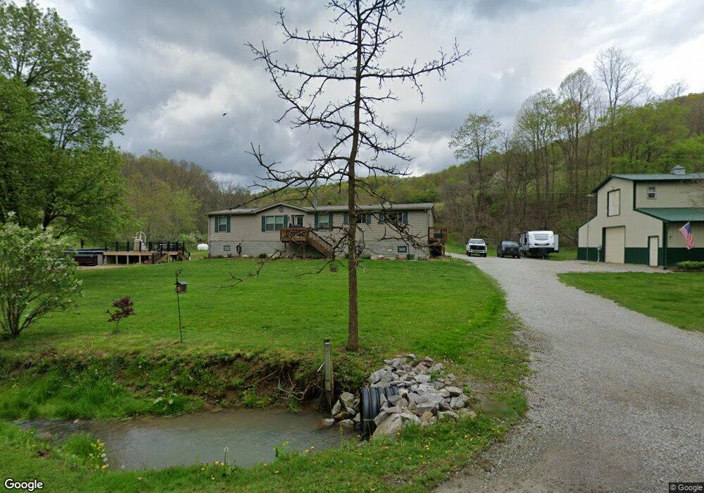
147 Turkey Hollow Rd Waynesburg, PA 15370
Estimated Value: $150,000 - $240,956
3
Beds
1
Bath
1,139
Sq Ft
$167/Sq Ft
Est. Value
About This Home
This home is located at 147 Turkey Hollow Rd, Waynesburg, PA 15370 and is currently estimated at $190,489, approximately $167 per square foot. 147 Turkey Hollow Rd is a home with nearby schools including West Greene El Center, West Greene High School, and West Greene Junior/Senior High School.
Ownership History
Date
Name
Owned For
Owner Type
Purchase Details
Closed on
Aug 8, 2025
Sold by
Carbon Fade Energy Llc
Bought by
Iron Pennsylvania Land Llc and Iron Coal Resources Llc
Current Estimated Value
Purchase Details
Closed on
Sep 12, 2024
Sold by
Iron Pennsylvania Land Llc and Iron Coal Resources Llc
Bought by
Carbon Fade Energy Llc
Purchase Details
Closed on
Aug 7, 2014
Sold by
Reese Gary L
Bought by
Reese Brandon L and Reese Candace L
Purchase Details
Closed on
Oct 19, 2006
Sold by
Federal National Mortgage Association
Bought by
Reese Gary L
Purchase Details
Closed on
Apr 21, 2006
Sold by
Reynolds Robert D and Reynolds Audrey L
Bought by
Fannie Mae
Create a Home Valuation Report for This Property
The Home Valuation Report is an in-depth analysis detailing your home's value as well as a comparison with similar homes in the area
Home Values in the Area
Average Home Value in this Area
Purchase History
| Date | Buyer | Sale Price | Title Company |
|---|---|---|---|
| Iron Pennsylvania Land Llc | -- | None Listed On Document | |
| Iron Pennsylvania Land Llc | -- | None Listed On Document | |
| Carbon Fade Energy Llc | $1,342,368 | None Listed On Document | |
| Reese Brandon L | -- | None Available | |
| Reese Gary L | $12,500 | None Available | |
| Fannie Mae | $11,000 | None Available |
Source: Public Records
Tax History Compared to Growth
Tax History
| Year | Tax Paid | Tax Assessment Tax Assessment Total Assessment is a certain percentage of the fair market value that is determined by local assessors to be the total taxable value of land and additions on the property. | Land | Improvement |
|---|---|---|---|---|
| 2025 | $4,069 | $128,520 | $8,670 | $119,850 |
| 2024 | $4,069 | $128,520 | $8,670 | $119,850 |
| 2023 | $4,069 | $128,520 | $8,670 | $119,850 |
| 2022 | $4,504 | $128,520 | $8,670 | $119,850 |
| 2021 | $4,504 | $142,240 | $8,670 | $133,570 |
| 2020 | $4,295 | $142,240 | $8,670 | $133,570 |
| 2019 | $4,295 | $142,240 | $8,670 | $133,570 |
| 2018 | $43 | $142,240 | $8,670 | $133,570 |
| 2017 | $1,045 | $142,240 | $8,670 | $133,570 |
| 2016 | -- | $35,040 | $8,670 | $26,370 |
| 2015 | -- | $35,040 | $8,670 | $26,370 |
| 2014 | -- | $22,800 | $8,670 | $14,130 |
| 2013 | -- | $22,800 | $8,670 | $14,130 |
Source: Public Records
Map
Nearby Homes
- 111 2nd St
- 213 Hargus Creek Rd
- 479 Bell Run Rd
- 0 Victoria Ln Unit 1705810
- 0 Lippencott Rd Unit 1718289
- 111 S West St
- 147 W Elm St
- 119 W Elm St
- 355 Park Ave
- 398 Sugar Run Rd
- 336 Fruit St
- 353 S Washington St
- 208 Huffman St
- 275 W College St
- 215 1st Ave
- 233 Second Ave
- 595 N Richhill St
- 272 E Lincoln St
- 255 6th Ave
- 154 East Alley
