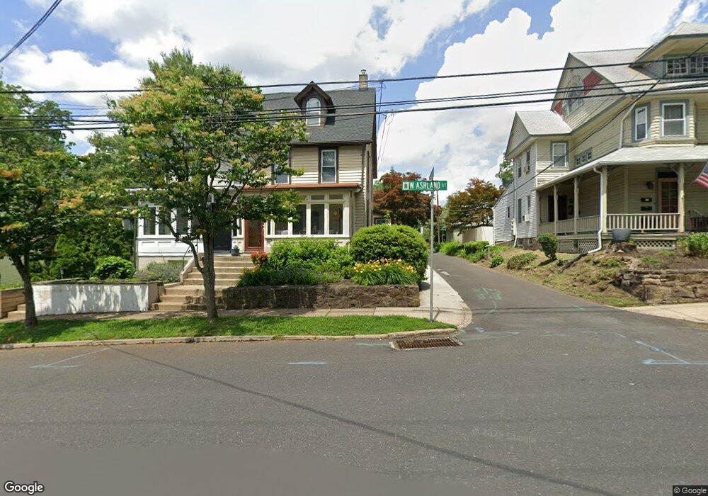
147 W Ashland St Doylestown, PA 18901
Estimated Value: $395,861 - $624,000
4
Beds
1
Bath
1,230
Sq Ft
$440/Sq Ft
Est. Value
About This Home
This home is located at 147 W Ashland St, Doylestown, PA 18901 and is currently estimated at $540,715, approximately $439 per square foot. 147 W Ashland St is a home located in Bucks County with nearby schools including Doyle El School, Lenape Middle School, and Central Bucks High School-West.
Ownership History
Date
Name
Owned For
Owner Type
Purchase Details
Closed on
Jul 1, 2008
Sold by
Farrington B Troy and Farrington Kelly C
Bought by
Yuknus Jennifer W
Current Estimated Value
Home Financials for this Owner
Home Financials are based on the most recent Mortgage that was taken out on this home.
Original Mortgage
$180,000
Outstanding Balance
$117,761
Interest Rate
6.35%
Mortgage Type
Stand Alone First
Estimated Equity
$422,954
Purchase Details
Closed on
Sep 8, 2004
Sold by
Farrington Kelly
Bought by
Farrington B Troy and Farrington Kelly
Create a Home Valuation Report for This Property
The Home Valuation Report is an in-depth analysis detailing your home's value as well as a comparison with similar homes in the area
Home Values in the Area
Average Home Value in this Area
Purchase History
| Date | Buyer | Sale Price | Title Company |
|---|---|---|---|
| Yuknus Jennifer W | $338,500 | None Available | |
| Farrington B Troy | -- | -- |
Source: Public Records
Mortgage History
| Date | Status | Borrower | Loan Amount |
|---|---|---|---|
| Open | Yuknus Jennifer W | $180,000 |
Source: Public Records
Tax History Compared to Growth
Tax History
| Year | Tax Paid | Tax Assessment Tax Assessment Total Assessment is a certain percentage of the fair market value that is determined by local assessors to be the total taxable value of land and additions on the property. | Land | Improvement |
|---|---|---|---|---|
| 2025 | $2,400 | $13,320 | $1,960 | $11,360 |
| 2024 | $2,400 | $13,320 | $1,960 | $11,360 |
| 2023 | $2,286 | $13,320 | $1,960 | $11,360 |
| 2022 | $2,254 | $13,320 | $1,960 | $11,360 |
| 2021 | $2,230 | $13,320 | $1,960 | $11,360 |
| 2020 | $2,205 | $13,320 | $1,960 | $11,360 |
| 2019 | $2,181 | $13,320 | $1,960 | $11,360 |
| 2018 | $2,154 | $13,320 | $1,960 | $11,360 |
| 2017 | $2,132 | $13,320 | $1,960 | $11,360 |
| 2016 | -- | $13,320 | $1,960 | $11,360 |
| 2015 | -- | $13,320 | $1,960 | $11,360 |
| 2014 | -- | $13,320 | $1,960 | $11,360 |
Source: Public Records
Map
Nearby Homes
- 195 Lafayette St
- 259 W Ashland St
- 37 N Clinton St
- 236 Green St
- 69 E Oakland Ave
- 110 E Ashland St
- 20 E Court St
- 403 S Main St Unit S201
- 89 Homestead Dr
- 4 Barnes Ct
- 155 E Oakland Ave
- 215 N Franklin St
- 9 Mill Creek Dr
- 169 N Main St
- 146 E Court St
- 146 N Church St
- 333 Dorset Ct Unit 333
- 339 E Ashland St
- 114 Progress Dr
- 78 Tower Hill Rd
- 149 W Ashland St
- 155 Bunker St
- 155 W Ashland St
- 133 W Ashland St
- 157 S West St
- 155 S West St
- 145 Bunker St
- 131 W Ashland St
- 157 W Ashland St
- 127 W Ashland St
- 137 Worthington St
- 151 S West St
- 149 S West St
- 135 Worthington St
- 119 W Ashland St
- 196 W Ashland St
- 129 Worthington St
- 128 Worthington St
- 117 W Ashland St
- 117 W Ashland St Unit 1B