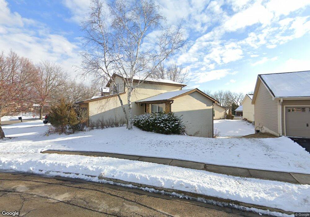
1470 Brookside Dr Hoffman Estates, IL 60169
South Hoffman Estates NeighborhoodEstimated Value: $377,691 - $413,000
3
Beds
2
Baths
1,450
Sq Ft
$272/Sq Ft
Est. Value
About This Home
This home is located at 1470 Brookside Dr, Hoffman Estates, IL 60169 and is currently estimated at $394,173, approximately $271 per square foot. 1470 Brookside Dr is a home located in Cook County with nearby schools including Neil Armstrong Elementary School, Dwight D Eisenhower Junior High School, and Hoffman Estates High School.
Ownership History
Date
Name
Owned For
Owner Type
Purchase Details
Closed on
Aug 20, 2001
Sold by
Mertes James A
Bought by
Bamberger James S
Current Estimated Value
Home Financials for this Owner
Home Financials are based on the most recent Mortgage that was taken out on this home.
Original Mortgage
$168,400
Interest Rate
6.99%
Mortgage Type
Balloon
Create a Home Valuation Report for This Property
The Home Valuation Report is an in-depth analysis detailing your home's value as well as a comparison with similar homes in the area
Home Values in the Area
Average Home Value in this Area
Purchase History
| Date | Buyer | Sale Price | Title Company |
|---|---|---|---|
| Bamberger James S | -- | -- | |
| Bamberger James S | $210,500 | -- |
Source: Public Records
Mortgage History
| Date | Status | Borrower | Loan Amount |
|---|---|---|---|
| Closed | Bamberger James S | $168,400 |
Source: Public Records
Tax History
| Year | Tax Paid | Tax Assessment Tax Assessment Total Assessment is a certain percentage of the fair market value that is determined by local assessors to be the total taxable value of land and additions on the property. | Land | Improvement |
|---|---|---|---|---|
| 2025 | $7,125 | $37,000 | $5,995 | $31,005 |
| 2024 | $7,125 | $26,533 | $5,450 | $21,083 |
| 2023 | $6,864 | $26,533 | $5,450 | $21,083 |
| 2022 | $6,864 | $26,533 | $5,450 | $21,083 |
| 2021 | $5,923 | $21,009 | $8,583 | $12,426 |
| 2020 | $5,859 | $21,009 | $8,583 | $12,426 |
| 2019 | $5,830 | $23,344 | $8,583 | $14,761 |
| 2018 | $6,259 | $22,631 | $7,493 | $15,138 |
| 2017 | $6,167 | $22,631 | $7,493 | $15,138 |
| 2016 | $5,998 | $22,631 | $7,493 | $15,138 |
| 2015 | $5,100 | $18,503 | $6,540 | $11,963 |
| 2014 | $5,027 | $18,503 | $6,540 | $11,963 |
| 2013 | $4,880 | $18,503 | $6,540 | $11,963 |
Source: Public Records
Map
Nearby Homes
- 1587 Brookside Dr
- 1612 Islandview Ct
- 1880 Bonnie Ln Unit 416
- 1880 Bonnie Ln Unit 112
- 1659 Islandview Ct
- 1975 Windsong Dr Unit 333E1
- 1724 Fayette Walk Unit J
- 1769 Sessions Walk Unit C
- 1712 Fayette Walk Unit D
- 1026 Denham Place Unit 1
- 1933 Williamsburg Dr Unit 1
- 2051 Kettering Rd Unit 2
- 2021 Kensington Ln Unit 3004
- 2027 Kensington Ln Unit 3001
- 2025 Kensington Ln Unit 3002
- 2023 Kensington Ln Unit 3003
- 1708 Southbridge Ct
- 1986 Brighton Ln Unit 2
- 2267 Briar Ct Unit 65
- 1103 Southbridge Ln
- 1460 Brookside Dr
- 1474 Brookside Dr
- 2050 Greens Ct
- 2040 Greens Ct
- 1478 Brookside Dr
- 2060 Greens Ct Unit 2
- 1465 Brookside Dr
- 1482 Brookside Dr
- 1455 Brookside Dr
- 2030 Greens Ct
- 1475 Brookside Dr
- 1500 Brookside Dr
- 1440 Brookside Dr
- 1486 Brookside Dr Unit 2
- 2070 Greens Ct
- 1490 Brookside Dr
- 1495 Cornell Ct Unit 5C
- 1995 Brookside Ln
- 1487 Cornell Ct Unit 4D
- 1487 Cornell Ct
Your Personal Tour Guide
Ask me questions while you tour the home.