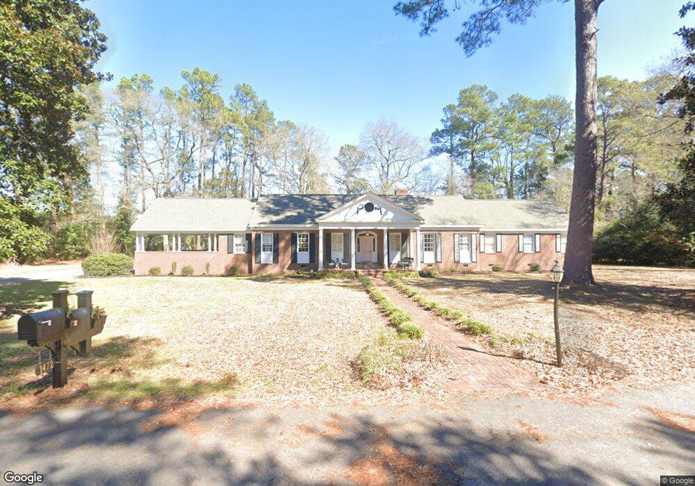
1472 Jasmine Ln Holly Hill, SC 29059
Estimated Value: $374,000 - $453,000
3
Beds
4
Baths
3,643
Sq Ft
$109/Sq Ft
Est. Value
About This Home
This home is located at 1472 Jasmine Ln, Holly Hill, SC 29059 and is currently estimated at $398,232, approximately $109 per square foot. 1472 Jasmine Ln is a home located in Orangeburg County with nearby schools including Holly Hill Elementary School, Holly Hill Elementary, and Holly Hill-Roberts Middle.
Ownership History
Date
Name
Owned For
Owner Type
Purchase Details
Closed on
Apr 6, 2020
Sold by
Monaco Albert L
Bought by
Locklear Derrick P and Locklear Rose Marie
Current Estimated Value
Home Financials for this Owner
Home Financials are based on the most recent Mortgage that was taken out on this home.
Original Mortgage
$232,500
Outstanding Balance
$205,576
Interest Rate
3.3%
Mortgage Type
VA
Estimated Equity
$192,656
Purchase Details
Closed on
Oct 8, 2014
Sold by
Estate Of Richard Henderson Cummings Jr
Bought by
Cummings Cynthia S
Create a Home Valuation Report for This Property
The Home Valuation Report is an in-depth analysis detailing your home's value as well as a comparison with similar homes in the area
Home Values in the Area
Average Home Value in this Area
Purchase History
| Date | Buyer | Sale Price | Title Company |
|---|---|---|---|
| Locklear Derrick P | $232,500 | None Available | |
| Cummings Cynthia S | -- | -- |
Source: Public Records
Mortgage History
| Date | Status | Borrower | Loan Amount |
|---|---|---|---|
| Open | Locklear Derrick P | $232,500 |
Source: Public Records
Tax History Compared to Growth
Tax History
| Year | Tax Paid | Tax Assessment Tax Assessment Total Assessment is a certain percentage of the fair market value that is determined by local assessors to be the total taxable value of land and additions on the property. | Land | Improvement |
|---|---|---|---|---|
| 2024 | $2,892 | $22,372 | $4,024 | $18,348 |
| 2023 | $2,476 | $16,693 | $3,229 | $13,464 |
| 2022 | $2,971 | $16,693 | $3,229 | $13,464 |
| 2021 | $2,937 | $16,693 | $3,229 | $13,464 |
| 2020 | $2,893 | $16,693 | $0 | $0 |
| 2019 | $2,904 | $16,693 | $0 | $0 |
| 2018 | $2,740 | $14,395 | $0 | $0 |
| 2017 | $2,721 | $14,395 | $0 | $0 |
| 2016 | $2,683 | $14,395 | $0 | $0 |
| 2015 | $2,105 | $14,395 | $0 | $0 |
| 2014 | $2,105 | $14,395 | $3,229 | $11,166 |
| 2013 | -- | $0 | $0 | $0 |
Source: Public Records
Map
Nearby Homes
- 1301 Bennett Cir
- 1000 Holly St
- 264 Walters Rd
- 0 Lindstedt Ln
- 0 Peake St
- 1691 Bennett Cir
- 1146 Bennett Cir
- 220 Brooks Dr
- 0 Bunch Ford Rd Unit 25021235
- BRANDON Plan at Evergreen
- CALI Plan at Evergreen
- HELENA Plan at Evergreen
- DOWNING Plan at Evergreen
- SULLIVAN Plan at Evergreen
- 1108 Gilmore Ave
- 208 Bunch Ford Rd
- 310 Bunch Ford Rd
- 130 Culbertson Ct
- 114 Culbertson Ct
- 414 Brooks Dr