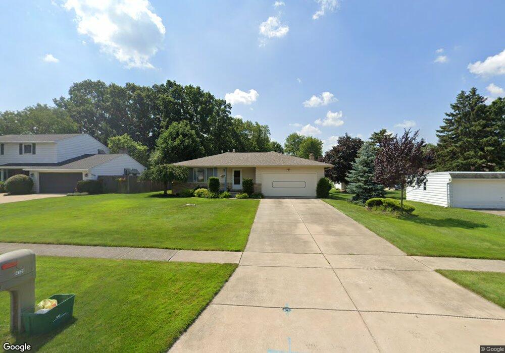
14729 Oakland Park Dr Strongsville, OH 44136
Estimated Value: $272,000 - $323,000
3
Beds
2
Baths
1,621
Sq Ft
$186/Sq Ft
Est. Value
About This Home
This home is located at 14729 Oakland Park Dr, Strongsville, OH 44136 and is currently estimated at $301,136, approximately $185 per square foot. 14729 Oakland Park Dr is a home located in Cuyahoga County with nearby schools including Strongsville High School, The Academy of St. Bartholomew, and Bethel Christian Academy.
Ownership History
Date
Name
Owned For
Owner Type
Purchase Details
Closed on
Mar 7, 1985
Sold by
Olderman Duane T
Bought by
Olderman Duane T
Current Estimated Value
Purchase Details
Closed on
Mar 12, 1980
Bought by
Olderman Duane T
Purchase Details
Closed on
Nov 2, 1979
Sold by
Richardson Gale D
Bought by
Employee Transfer Corp
Purchase Details
Closed on
Apr 15, 1977
Sold by
Richardson Gale D and D A
Bought by
Richardson Gale D
Purchase Details
Closed on
Jan 1, 1975
Bought by
Richardson Gale D and D A
Create a Home Valuation Report for This Property
The Home Valuation Report is an in-depth analysis detailing your home's value as well as a comparison with similar homes in the area
Home Values in the Area
Average Home Value in this Area
Purchase History
| Date | Buyer | Sale Price | Title Company |
|---|---|---|---|
| Olderman Duane T | -- | -- | |
| Olderman Duane T | $78,500 | -- | |
| Employee Transfer Corp | $82,500 | -- | |
| Richardson Gale D | -- | -- | |
| Richardson Gale D | -- | -- |
Source: Public Records
Tax History Compared to Growth
Tax History
| Year | Tax Paid | Tax Assessment Tax Assessment Total Assessment is a certain percentage of the fair market value that is determined by local assessors to be the total taxable value of land and additions on the property. | Land | Improvement |
|---|---|---|---|---|
| 2024 | $3,881 | $92,470 | $19,040 | $73,430 |
| 2023 | $3,882 | $71,160 | $20,300 | $50,860 |
| 2022 | $3,879 | $71,160 | $20,300 | $50,860 |
| 2021 | $3,849 | $71,160 | $20,300 | $50,860 |
| 2020 | $3,558 | $59,780 | $17,050 | $42,740 |
| 2019 | $3,454 | $170,800 | $48,700 | $122,100 |
| 2018 | $3,078 | $59,780 | $17,050 | $42,740 |
| 2017 | $3,077 | $55,130 | $16,560 | $38,570 |
| 2016 | $3,052 | $55,130 | $16,560 | $38,570 |
| 2015 | $2,987 | $55,130 | $16,560 | $38,570 |
| 2014 | $2,987 | $53,520 | $16,070 | $37,450 |
Source: Public Records
Map
Nearby Homes
- 9531 Nicole Cir
- 9129 Tahoe Cir
- 13976 W Sprague Rd
- 14015 Byron Blvd
- 9890 Webster Rd
- 10010 Chevy Chase
- 7685 Saratoga Rd
- Buchanan Plan at The Enclave at Pine Lakes Crossing
- Belleville Plan at The Enclave at Pine Lakes Crossing
- 8761 Windfall Ct
- 7664 Gerald Dr
- 9945 Twelve Oaks Cir
- 0 Webster Rd
- 12972 W Sprague Rd
- 14069 Basswood Cir
- 13541 Indian Creek Dr
- 14280 Pawnee Trail
- 14330 Pawnee Trail
- 15485 Albion Rd
- 10369 Council Bluff
- 14685 Oakland Park Dr
- 8623 Webster Rd
- 8581 Webster Rd
- 14657 Oakland Park Dr
- 8671 Webster Rd
- 8646 Oak Leaf Dr
- 14605 Oakland Park Dr
- 8713 Webster Rd
- 8493 Webster Rd
- 14730 Oakland Park Dr
- 14622 Century Oak Dr
- 14686 Oakland Park Dr
- 8684 Oak Leaf Dr
- 8721 Webster Rd
- 14593 Oakland Park Dr
- 8451 Webster Rd
- 8526 Litto Dr
- 14578 Century Oak Dr
- 8580 Webster Rd
- 8630 Webster Rd