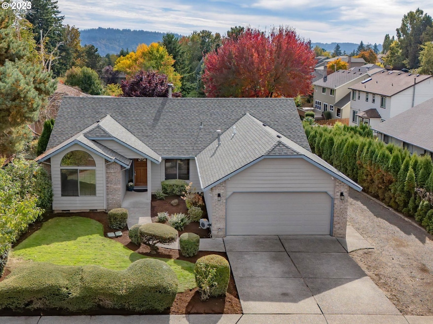
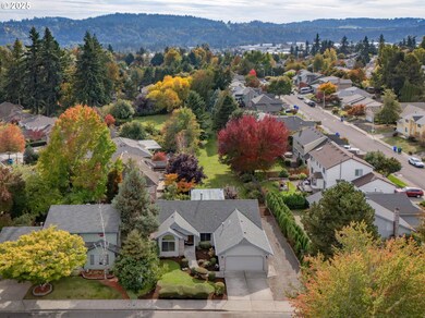
14734 SE 131st Dr Clackamas, OR 97015
Estimated payment $3,337/month
Highlights
- RV Access or Parking
- Wood Burning Stove
- Park or Greenbelt View
- Oregon Trail Elementary School Rated A-
- Adjacent to Greenbelt
- Private Yard
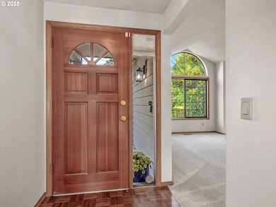
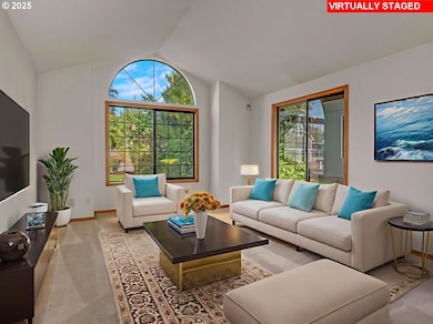
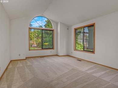
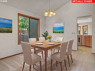
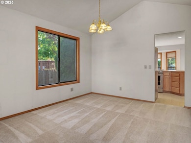
About This Home
This wonderful single-level home sits on a spectacular lot with views of the lush green space and an expansive RV parking area that is 74+ feet long and 13 feet wide. The home offers a light and bright living room, an open kitchen/family room area, 3 spacious bedrooms, and an indoor laundry room. Mechanical updates include a newer gas furnace (2022) and water heater, plus the roof and gutters were replaced in 2009. Loads of storage with a good-sized 2-car garage and a large crawl space that has exterior access and storage shelving. You can't beat the convenient location, which is close to shopping, restaurants, Clackamas High School, and situated on a quiet street in an attractive neighborhood.
Home Details
Home Type
- Single Family
Est. Annual Taxes
- $5,730
Year Built
- Built in 1989
Lot Details
- 6,969 Sq Ft Lot
- Adjacent to Greenbelt
- Sprinkler System
- Private Yard
- Garden
HOA Fees
- $23 Monthly HOA Fees
Parking
- 2 Car Attached Garage
- Garage Door Opener
- RV Access or Parking
Home Design
- Composition Roof
- Lap Siding
- Plywood Siding Panel T1-11
- Concrete Perimeter Foundation
- Wood Composite
Interior Spaces
- 1,693 Sq Ft Home
- 1-Story Property
- Ceiling Fan
- Skylights
- Wood Burning Stove
- Wood Burning Fireplace
- Double Pane Windows
- Family Room
- Living Room
- Dining Room
- Utility Room
- Laundry Room
- Wall to Wall Carpet
- Park or Greenbelt Views
- Crawl Space
- Security System Owned
Kitchen
- Built-In Range
- Plumbed For Ice Maker
- Dishwasher
- Cooking Island
- Disposal
Bedrooms and Bathrooms
- 3 Bedrooms
- 2 Full Bathrooms
Accessible Home Design
- Accessibility Features
- Level Entry For Accessibility
Outdoor Features
- Covered Patio or Porch
Schools
- Oregon Trail Elementary School
- Rock Creek Middle School
- Clackamas High School
Utilities
- Forced Air Heating and Cooling System
- Heating System Uses Gas
- Gas Water Heater
- High Speed Internet
Listing and Financial Details
- Assessor Parcel Number 00480018
Community Details
Overview
- Comanche Bluff Property Owners Assoc. Association, Phone Number (971) 275-2315
- Comanche Bluff Subdivision
- Greenbelt
Amenities
- Common Area
Map
Home Values in the Area
Average Home Value in this Area
Tax History
| Year | Tax Paid | Tax Assessment Tax Assessment Total Assessment is a certain percentage of the fair market value that is determined by local assessors to be the total taxable value of land and additions on the property. | Land | Improvement |
|---|---|---|---|---|
| 2025 | $5,730 | $300,506 | -- | -- |
| 2024 | $5,528 | $291,754 | -- | -- |
| 2023 | $5,528 | $283,257 | $0 | $0 |
| 2022 | $5,086 | $275,007 | $0 | $0 |
| 2021 | $4,898 | $266,998 | $0 | $0 |
| 2020 | $4,591 | $259,222 | $0 | $0 |
| 2019 | $4,544 | $251,672 | $0 | $0 |
| 2018 | $4,099 | $244,342 | $0 | $0 |
| 2017 | $3,969 | $237,225 | $0 | $0 |
| 2016 | $3,829 | $230,316 | $0 | $0 |
| 2015 | $3,721 | $223,608 | $0 | $0 |
| 2014 | $3,454 | $217,095 | $0 | $0 |
Property History
| Date | Event | Price | List to Sale | Price per Sq Ft |
|---|---|---|---|---|
| 11/05/2025 11/05/25 | Pending | -- | -- | -- |
| 10/30/2025 10/30/25 | For Sale | $539,000 | 0.0% | $318 / Sq Ft |
| 10/24/2025 10/24/25 | Pending | -- | -- | -- |
| 10/20/2025 10/20/25 | For Sale | $539,000 | -- | $318 / Sq Ft |
Purchase History
| Date | Type | Sale Price | Title Company |
|---|---|---|---|
| Warranty Deed | -- | None Listed On Document | |
| Individual Deed | $152,500 | Fidelity National Title Co |
Mortgage History
| Date | Status | Loan Amount | Loan Type |
|---|---|---|---|
| Previous Owner | $122,000 | No Value Available |
Source: Regional Multiple Listing Service (RMLS)
MLS Number: 436711484
APN: 00480018
Disclaimer: Certain information contained herein is derived from information provided by parties other than Homes.com. All information provided is deemed reliable, but is not guaranteed to be accurate and should be independently verified.
![]() The content relating to real estate for sale on this web site comes in part from the IDX program of the RMLS™ of Portland, Oregon. Real estate listings held by brokerage firms other than Ten-X are marked with the RMLS™ logo, and detailed information about these properties includes the names of the listing brokers. Listing content is copyright © 2025 RMLS™, Portland, Oregon. Some properties which appear for sale on this web site may subsequently have sold or may no longer be available. All information provided is deemed reliable but is not guaranteed and should be independently verified.
The content relating to real estate for sale on this web site comes in part from the IDX program of the RMLS™ of Portland, Oregon. Real estate listings held by brokerage firms other than Ten-X are marked with the RMLS™ logo, and detailed information about these properties includes the names of the listing brokers. Listing content is copyright © 2025 RMLS™, Portland, Oregon. Some properties which appear for sale on this web site may subsequently have sold or may no longer be available. All information provided is deemed reliable but is not guaranteed and should be independently verified.
- 14646 SE Megan Way
- 14880 SE Marci Way
- 14198 SE Iseli Ln
- 14196 SE Iseli Ln
- 14186 SE Iseli Ln
- 13543 SE Almond Dr
- 14192 SE Iseli Ln
- 14191 SE Iseli Ln
- 14194 SE Iseli Ln
- 17303 SE 130th Ave
- 14890 SE Lostine Dr
- 12015 SE Regal Ct
- 12239 SE Ashley St
- 13513 SE 132nd Ave
- 13592 SE Sierra Dr
- 13526 SE Ellen Dr
- 13543 SE 126th Ave
- 11782 SE Mountain Sun Dr
- 11985 SE Eddies Way
- 11867 SE Mountain Sun Dr
