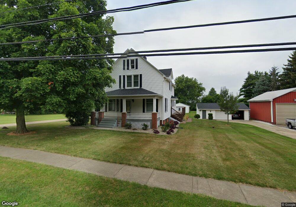
14738 S Pricetown Rd Damascus, OH 44619
Estimated Value: $190,942 - $221,000
3
Beds
1
Bath
1,737
Sq Ft
$121/Sq Ft
Est. Value
About This Home
This home is located at 14738 S Pricetown Rd, Damascus, OH 44619 and is currently estimated at $209,986, approximately $120 per square foot. 14738 S Pricetown Rd is a home with nearby schools including West Branch Middle School and West Branch High School.
Ownership History
Date
Name
Owned For
Owner Type
Purchase Details
Closed on
Apr 25, 2014
Sold by
Powell Tim and Powell Sabrina
Bought by
Cosma Deborah R
Current Estimated Value
Purchase Details
Closed on
Jul 13, 2005
Sold by
Pukalski Deborah R
Bought by
Powell Tim and Powell Sabrina
Home Financials for this Owner
Home Financials are based on the most recent Mortgage that was taken out on this home.
Original Mortgage
$87,920
Interest Rate
5.69%
Mortgage Type
Fannie Mae Freddie Mac
Purchase Details
Closed on
Nov 9, 1989
Bought by
Close Deborah R
Create a Home Valuation Report for This Property
The Home Valuation Report is an in-depth analysis detailing your home's value as well as a comparison with similar homes in the area
Home Values in the Area
Average Home Value in this Area
Purchase History
| Date | Buyer | Sale Price | Title Company |
|---|---|---|---|
| Cosma Deborah R | $145,000 | Heritage Union Title Co Ltd | |
| Powell Tim | -- | First American Title | |
| Close Deborah R | $7,000 | -- |
Source: Public Records
Mortgage History
| Date | Status | Borrower | Loan Amount |
|---|---|---|---|
| Previous Owner | Powell Tim | $87,920 | |
| Closed | Powell Tim | $16,485 |
Source: Public Records
Tax History Compared to Growth
Tax History
| Year | Tax Paid | Tax Assessment Tax Assessment Total Assessment is a certain percentage of the fair market value that is determined by local assessors to be the total taxable value of land and additions on the property. | Land | Improvement |
|---|---|---|---|---|
| 2024 | $2,114 | $54,590 | $3,220 | $51,370 |
| 2023 | $2,011 | $54,590 | $3,220 | $51,370 |
| 2022 | $1,985 | $45,640 | $2,630 | $43,010 |
| 2021 | $1,928 | $45,640 | $2,630 | $43,010 |
| 2020 | $1,936 | $45,640 | $2,630 | $43,010 |
| 2019 | $1,764 | $38,770 | $2,630 | $36,140 |
| 2018 | $1,756 | $38,770 | $2,630 | $36,140 |
| 2017 | $1,733 | $38,770 | $2,630 | $36,140 |
| 2016 | $1,328 | $29,580 | $2,630 | $26,950 |
| 2015 | $1,291 | $29,580 | $2,630 | $26,950 |
| 2014 | $1,293 | $29,490 | $2,540 | $26,950 |
| 2013 | $1,288 | $29,490 | $2,540 | $26,950 |
Source: Public Records
Map
Nearby Homes
- 14930 S Pricetown Rd
- 14831 Smith Goshen Rd
- 14965 Seacrist Rd
- 14980 Salem Alliance Rd
- 29979 Salem-Alliance Rd
- 30051 Sr 62
- 28339 Misty Morning Ln
- 17394 State Route 62
- 27443 State Route 62
- 35 Bayview Dr
- 17880 State Route 62
- 1497 Lake Front Dr
- 1511 Lake Front Dr
- 18061 Derr Ave
- 1445 Georgetown Damascus Rd
- 29655 Buck Rd
- 14609 S Duck Creek Rd
- 26223 Wildwood Dr
- 27696 Buck Rd
- 31085 Georgetown Rd
- 14724 S Pricetown Rd
- 14743 S Pricetown Rd
- 15962 4th St
- 14765 S Pricetown Rd
- 14762 S Pricetown Rd
- 14706 S Pricetown Rd
- 14780 S Pricetown Rd
- 14717 S Pricetown Rd
- 14789 S Pricetown Rd
- 14798 S Pricetown Rd
- 14693 S Pricetown Rd
- 14801 S Pricetown Rd
- 14732 French St
- 15962 4th St
- 14674 S Pricetown Rd
- 14673 S Pricetown Rd
- 0 5th St Unit 4331097
- 0 5th St Unit 4151055
- 14818 S Pricetown Rd
- 14825 S Pricetown Rd