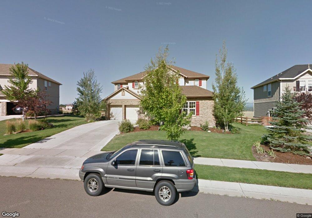
14743 Snowcrest Dr Broomfield, CO 80023
North Broomfield NeighborhoodEstimated Value: $1,276,994 - $1,730,000
4
Beds
4
Baths
3,577
Sq Ft
$396/Sq Ft
Est. Value
About This Home
This home is located at 14743 Snowcrest Dr, Broomfield, CO 80023 and is currently estimated at $1,417,999, approximately $396 per square foot. 14743 Snowcrest Dr is a home located in Broomfield County with nearby schools including Coyote Ridge Elementary School, Westlake Middle School, and Legacy High School.
Ownership History
Date
Name
Owned For
Owner Type
Purchase Details
Closed on
Jul 5, 2005
Sold by
Standard Pacific Of Colorado Inc
Bought by
Hamilton Craig A and Hamilton Ranae L
Current Estimated Value
Home Financials for this Owner
Home Financials are based on the most recent Mortgage that was taken out on this home.
Original Mortgage
$150,000
Outstanding Balance
$78,150
Interest Rate
5.63%
Mortgage Type
Fannie Mae Freddie Mac
Estimated Equity
$1,339,849
Create a Home Valuation Report for This Property
The Home Valuation Report is an in-depth analysis detailing your home's value as well as a comparison with similar homes in the area
Home Values in the Area
Average Home Value in this Area
Purchase History
| Date | Buyer | Sale Price | Title Company |
|---|---|---|---|
| Hamilton Craig A | $657,284 | Land Title |
Source: Public Records
Mortgage History
| Date | Status | Borrower | Loan Amount |
|---|---|---|---|
| Open | Hamilton Craig A | $150,000 |
Source: Public Records
Tax History
| Year | Tax Paid | Tax Assessment Tax Assessment Total Assessment is a certain percentage of the fair market value that is determined by local assessors to be the total taxable value of land and additions on the property. | Land | Improvement |
|---|---|---|---|---|
| 2025 | $12,269 | $95,150 | $25,930 | $69,220 |
| 2024 | $12,269 | $94,190 | $24,950 | $69,240 |
| 2023 | $12,183 | $101,530 | $26,900 | $74,630 |
| 2022 | $9,192 | $69,920 | $18,310 | $51,610 |
| 2021 | $9,474 | $71,940 | $18,840 | $53,100 |
| 2020 | $8,770 | $66,620 | $17,020 | $49,600 |
| 2019 | $8,773 | $67,090 | $17,140 | $49,950 |
| 2018 | $8,276 | $62,030 | $15,440 | $46,590 |
| 2017 | $8,711 | $68,580 | $17,070 | $51,510 |
| 2016 | $8,799 | $61,420 | $13,130 | $48,290 |
Source: Public Records
Map
Nearby Homes
- 5033 Silver Feather Way
- 4892 Raven Run
- 4859 Raven Run
- 14578 Benton St
- 14314 Wright Way
- 5151 Spyglass Dr
- 14534 Fenton St
- 4534 Fairway Ln
- 4405 Fairway Ln
- 14278 Currant St
- 5605 W 141st Ln
- 14025 Blue River Trail
- 5626 W 142nd Ave
- 5630 W 142nd Ave
- 5621 W 141st Ln
- 5632 W 142nd Ave
- Blanca Plan at Dillon Pointe - Skyview
- Columbia Plan at Dillon Pointe - Skyview
- Antora Plan at Dillon Pointe - Skyview
- 14281 Currant St
- 14753 Snowcrest Dr
- 14733 Snowcrest Dr
- 4820 Mountain Gold Run
- 14763 Snowcrest Dr
- 14723 Sorrel Dr
- 4821 Mountain Gold Run
- 14730 Snowcrest Dr
- 4810 Mountain Gold Run
- 14713 Sorrel Dr
- 14803 Snowcrest Dr
- 4811 Mountain Gold Run
- 14720 Sorrel Run
- 4800 Mountain Gold Run
- 14802 Snowcrest Dr
- 14703 Sorrel Dr
- 5003 Silver Feather Way
- 5004 Silver Feather Way
- 14701 Sorrel Run
- 14710 Sorrel Run
- 14813 Snowcrest Dr