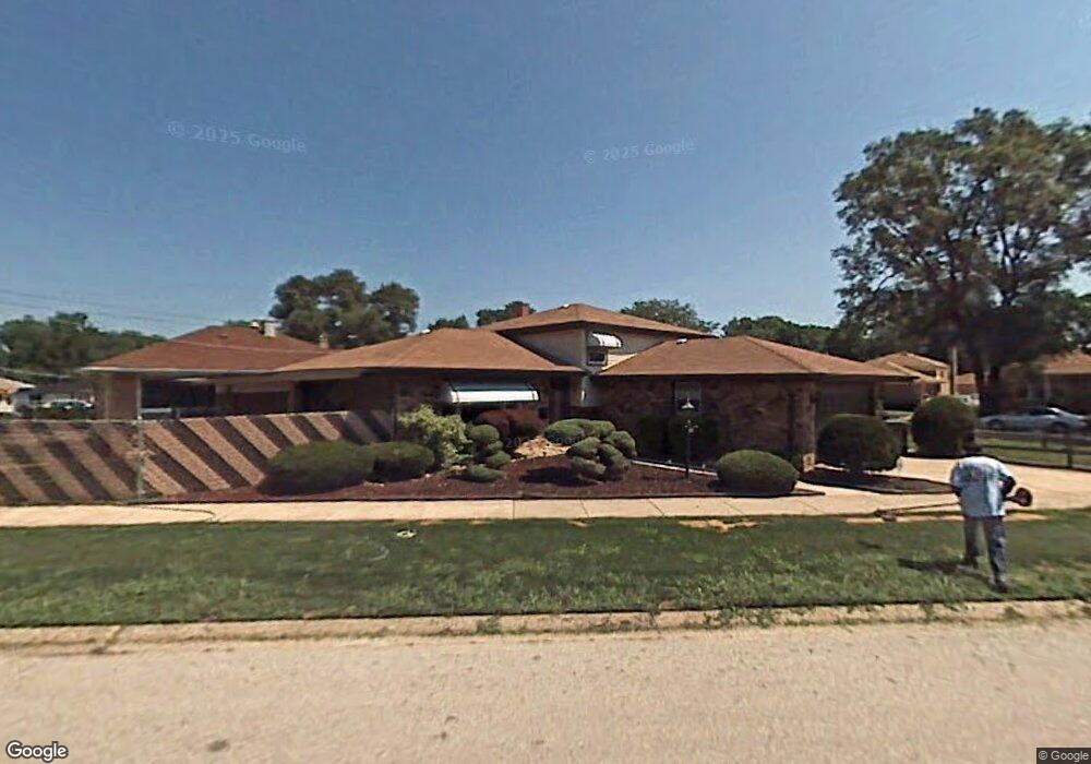
14749 Shepard Dr Dolton, IL 60419
Estimated Value: $155,000 - $172,000
3
Beds
2
Baths
1,128
Sq Ft
$146/Sq Ft
Est. Value
About This Home
This home is located at 14749 Shepard Dr, Dolton, IL 60419 and is currently estimated at $164,673, approximately $145 per square foot. 14749 Shepard Dr is a home located in Cook County with nearby schools including Berger-Vandenberg Elementary School, Creative Communications Academy, and School Of Fine Arts Academy.
Ownership History
Date
Name
Owned For
Owner Type
Purchase Details
Closed on
Apr 29, 1994
Sold by
Sharp Clifton E and Sharp Adele J
Bought by
Randall Gladys
Current Estimated Value
Home Financials for this Owner
Home Financials are based on the most recent Mortgage that was taken out on this home.
Original Mortgage
$83,505
Interest Rate
7.88%
Create a Home Valuation Report for This Property
The Home Valuation Report is an in-depth analysis detailing your home's value as well as a comparison with similar homes in the area
Home Values in the Area
Average Home Value in this Area
Purchase History
| Date | Buyer | Sale Price | Title Company |
|---|---|---|---|
| Randall Gladys | $88,000 | -- |
Source: Public Records
Mortgage History
| Date | Status | Borrower | Loan Amount |
|---|---|---|---|
| Closed | Randall Gladys | $83,505 |
Source: Public Records
Tax History
| Year | Tax Paid | Tax Assessment Tax Assessment Total Assessment is a certain percentage of the fair market value that is determined by local assessors to be the total taxable value of land and additions on the property. | Land | Improvement |
|---|---|---|---|---|
| 2025 | $74 | $13,000 | $2,498 | $10,502 |
| 2024 | $74 | $13,000 | $2,498 | $10,502 |
| 2023 | $99 | $13,000 | $2,498 | $10,502 |
| 2022 | $99 | $11,973 | $2,204 | $9,769 |
| 2021 | $91 | $11,973 | $2,204 | $9,769 |
| 2020 | $79 | $11,973 | $2,204 | $9,769 |
| 2019 | $100 | $7,708 | $2,057 | $5,651 |
| 2018 | $109 | $7,708 | $2,057 | $5,651 |
| 2017 | $1,122 | $7,708 | $2,057 | $5,651 |
| 2016 | $2,144 | $7,644 | $1,910 | $5,734 |
| 2015 | $1,938 | $7,644 | $1,910 | $5,734 |
| 2014 | $2,681 | $8,813 | $1,910 | $6,903 |
| 2013 | $4,556 | $10,618 | $1,910 | $8,708 |
Source: Public Records
Map
Nearby Homes
- 14761 Lincoln Ave
- 14720 Shepard Dr
- 14731 Kimbark Ave
- 14635 Woodlawn Ave
- 14737 Kimbark Ave
- 14708 Shepard Dr
- 14637 Kenwood Ave
- 14846 Woodlawn Ave
- 14738 Dante Ave
- 14521 Kenwood Ave
- 14631 Lincoln Ave
- 14738 Blackstone Ave
- 14525 Dobson Ave
- 1107 E 145th St
- 14610 Blackstone Ave
- 1425 Kasten Dr
- 15020 Woodlawn Ave
- 1212 E 151st St
- 14405 Woodlawn Ave
- 15043 Meadow Ln
- 14724 Avalon Ave
- 14722 Avalon Ave
- 14760 Shepard Dr
- 14720 Avalon Ave
- 14731 Avalon Ave
- 14731 Avalon Ave
- 14716 Avalon Ave
- 14733 Avalon Ave
- 14727 Avalon Ave
- 14744 Avalon Ave
- 14737 Avalon Ave
- 14731 Woodlawn Ave
- 14723 Avalon Ave
- 14714 Avalon Ave
- 14721 Avalon Ave
- 14743 Woodlawn Ave
- 14715 Woodlawn Ave
- 14717 Avalon Ave
- 14745 Woodlawn Ave
- 14710 Avalon Ave
Your Personal Tour Guide
Ask me questions while you tour the home.