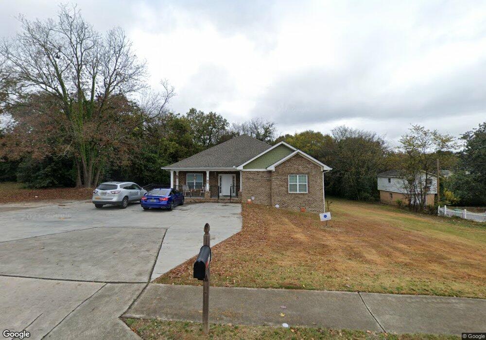
1475 Anthony Rd Macon, GA 31206
Estimated Value: $123,000 - $249,839
4
Beds
3
Baths
2,434
Sq Ft
$84/Sq Ft
Est. Value
About This Home
This home is located at 1475 Anthony Rd, Macon, GA 31206 and is currently estimated at $204,946, approximately $84 per square foot. 1475 Anthony Rd is a home located in Bibb County with nearby schools including Hartley Elementary School, Southwest High School, and Cirrus Charter Academy.
Ownership History
Date
Name
Owned For
Owner Type
Purchase Details
Closed on
Dec 4, 2017
Sold by
Macon Bibb County Land Bank Authority Pr
Bought by
Georgia Disability Possibilities Inc
Current Estimated Value
Purchase Details
Closed on
Jul 10, 2013
Sold by
The Housing Authority Of The City Of Mac
Bought by
Macon Bibb County Land Bank Authority In
Purchase Details
Closed on
Jun 4, 2008
Sold by
The Macon Bibb County Land Bank Authorit
Bought by
The Housing Authority Of The City Of Mac and Macon Housing Authority
Purchase Details
Closed on
Jan 11, 2007
Sold by
City Of Macon
Bought by
Macon Bibb Co Land Bank
Create a Home Valuation Report for This Property
The Home Valuation Report is an in-depth analysis detailing your home's value as well as a comparison with similar homes in the area
Home Values in the Area
Average Home Value in this Area
Purchase History
| Date | Buyer | Sale Price | Title Company |
|---|---|---|---|
| Georgia Disability Possibilities Inc | -- | None Available | |
| Macon Bibb County Land Bank Authority In | -- | None Available | |
| The Housing Authority Of The City Of Mac | -- | None Available | |
| Macon Bibb Co Land Bank | -- | -- |
Source: Public Records
Tax History Compared to Growth
Tax History
| Year | Tax Paid | Tax Assessment Tax Assessment Total Assessment is a certain percentage of the fair market value that is determined by local assessors to be the total taxable value of land and additions on the property. | Land | Improvement |
|---|---|---|---|---|
| 2025 | -- | $112,929 | $4,175 | $108,754 |
| 2024 | -- | $112,929 | $4,175 | $108,754 |
| 2023 | $0 | $112,929 | $4,175 | $108,754 |
| 2022 | $3,288 | $86,514 | $7,037 | $79,477 |
| 2021 | $3,288 | $86,514 | $7,037 | $79,477 |
| 2020 | $3,458 | $86,514 | $7,037 | $79,477 |
| 2019 | $3,458 | $86,514 | $7,037 | $79,477 |
| 2018 | $1,850 | $46,294 | $7,037 | $39,257 |
| 2017 | $0 | $7,037 | $7,037 | $0 |
| 2016 | $0 | $7,037 | $7,037 | $0 |
| 2015 | -- | $7,037 | $7,037 | $0 |
| 2014 | -- | $12,716 | $7,037 | $5,680 |
Source: Public Records
Map
Nearby Homes
- 1545 Anthony Rd
- 1049 Anthony Rd
- 1045 Anthony Rd
- 2125 Cedar Ave
- 710 Poppy Ave
- 2249 Lowe St
- 210 Moseley Ave
- 2350 Anthony Terrace
- 2032 Vining Cir
- 777 Grosso Ave
- 755 Grosso Ave
- 576 Pansy Ave
- 742 Grayson Ave
- 2349 Mason St
- 1191 Carroll St
- 815 Edwards Ave
- 2678 Mercer University Dr
- 284 Grosso Ave
- 466 Petunia Ave
- 1144 Carroll St
- 1411 Anthony Rd
- 1491 Anthony Rd
- 1484 Lowe Ct
- 1481 Lowe Ct
- 1495 Anthony Rd
- 0 Anthony Rd Unit 166094
- 0 Anthony Rd Unit A 184995
- 0 Anthony Rd Unit 8597776
- 0 Anthony Rd Unit 7457173
- 1490 Lowe Ct
- 2157 Cedar Ave
- 2167 Cedar Ave
- 1470 Anthony Rd
- 1460 Anthony Rd
- 1499 Anthony Rd
- 1480 Anthony Rd
- 1444 Anthony Rd
- 1487 Lowe Ct
- 1486 Anthony Rd
- 1434 Anthony Rd