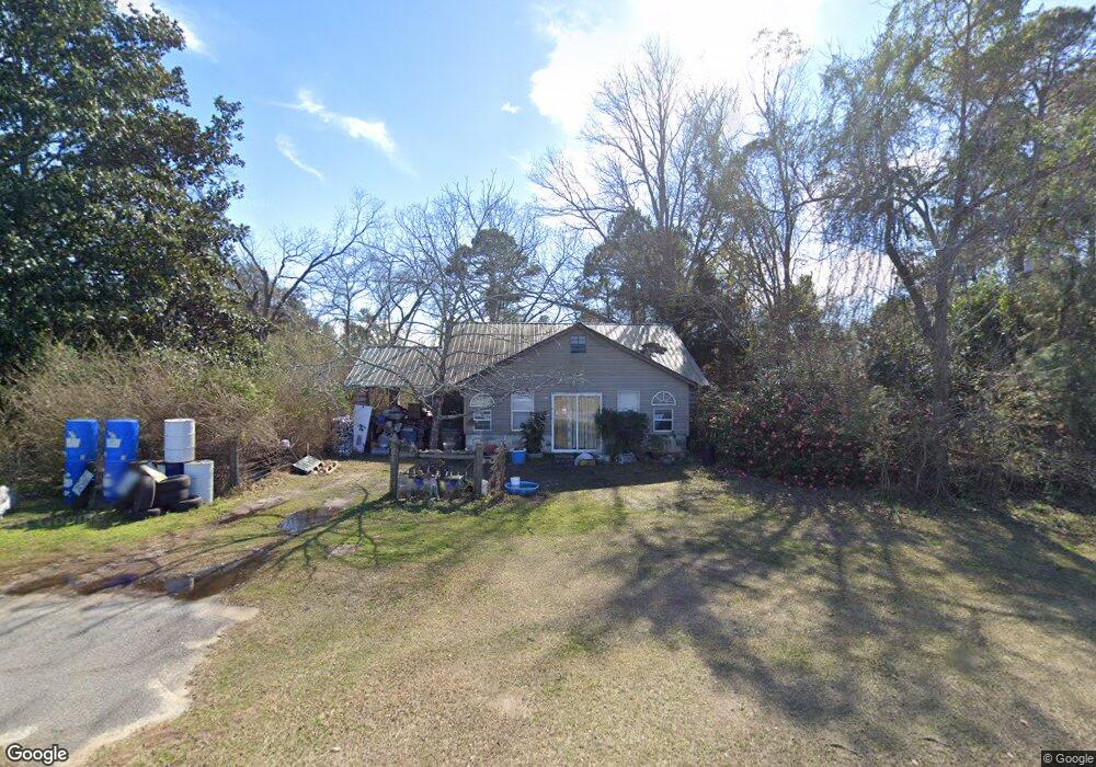
14762 Ga Highway 46 W Metter, GA 30439
Estimated Value: $100,456 - $264,000
2
Beds
1
Bath
1,224
Sq Ft
$136/Sq Ft
Est. Value
About This Home
This home is located at 14762 Ga Highway 46 W, Metter, GA 30439 and is currently estimated at $165,864, approximately $135 per square foot. 14762 Ga Highway 46 W is a home located in Candler County with nearby schools including Metter Elementary School, Metter Intermediate School, and Metter Middle School.
Ownership History
Date
Name
Owned For
Owner Type
Purchase Details
Closed on
Jan 27, 2010
Sold by
Daughtry & Daughtry Lllp
Bought by
Daughtry Carl
Current Estimated Value
Purchase Details
Closed on
Mar 9, 2005
Sold by
Bankey Lynn F
Bought by
Bankey Lynn F and Bankey Richard C
Purchase Details
Closed on
Mar 6, 2002
Sold by
Citifinancial Mortgage Company Inc
Bought by
Bankey Lynn F
Purchase Details
Closed on
Dec 4, 2001
Sold by
Miller Roscoe and Miller Chr
Bought by
Citifinancial Mortag
Purchase Details
Closed on
Sep 30, 1999
Sold by
Carter Carter and Carter Spell
Bought by
Carter Martha S
Purchase Details
Closed on
Sep 25, 1999
Sold by
Carter Martha and Carter Pel
Bought by
Miller Roscoe
Purchase Details
Closed on
Jan 1, 1993
Sold by
Bland Frank
Bought by
Carter Carter and Carter Spell
Create a Home Valuation Report for This Property
The Home Valuation Report is an in-depth analysis detailing your home's value as well as a comparison with similar homes in the area
Home Values in the Area
Average Home Value in this Area
Purchase History
| Date | Buyer | Sale Price | Title Company |
|---|---|---|---|
| Daughtry Carl | -- | -- | |
| Bankey Lynn F | -- | -- | |
| Bankey Lynn F | $20,000 | -- | |
| Citifinancial Mortag | $34,000 | -- | |
| Carter Martha S | -- | -- | |
| Miller Roscoe | $16,500 | -- | |
| Carter Carter | $71,900 | -- |
Source: Public Records
Tax History Compared to Growth
Tax History
| Year | Tax Paid | Tax Assessment Tax Assessment Total Assessment is a certain percentage of the fair market value that is determined by local assessors to be the total taxable value of land and additions on the property. | Land | Improvement |
|---|---|---|---|---|
| 2024 | $842 | $23,705 | $6,405 | $17,300 |
| 2023 | $842 | $23,310 | $6,405 | $16,905 |
| 2022 | $749 | $20,302 | $6,405 | $13,897 |
| 2021 | $660 | $18,655 | $6,405 | $12,250 |
| 2020 | $656 | $18,456 | $6,405 | $12,051 |
| 2019 | $657 | $18,456 | $6,405 | $12,051 |
| 2018 | $497 | $17,831 | $6,600 | $11,231 |
| 2017 | $466 | $17,831 | $6,600 | $11,231 |
| 2016 | $672 | $17,831 | $6,600 | $11,231 |
| 2015 | $200 | $17,830 | $6,600 | $11,231 |
| 2014 | $200 | $17,831 | $6,600 | $11,231 |
Source: Public Records
Map
Nearby Homes
- 0 Edenfield Rd
- 26844 Georgia 46
- 0 Kermit Rd
- 02 MacWac Lake Rd
- 14450 Stillmore Hwy
- 527 Windmill Rd
- Pittman Road and Hwy 121 S
- 615 Railroad Ave
- 0 Griffin Ferry Rd Unit SA336141
- 0 Griffin Ferry Rd Unit 10439452
- 0 Mann Sikes Rd Unit 10612891
- 286 Webb Cir
- 50 Grove Hollow Rd
- LOT 5 Grove Hollow Rd
- 4515 Harper Rd
- 0 Henry Moxley Rd Unit 24437680
- 0 Henry Moxley Rd Unit 10582632
- 1449 Hulsey Dr
- 743 Ann's Ln
- 6424 Collins Rd
- 0 Brumley Rd Unit 8588244
- 0 Brumley Rd Unit 8274350
- 268 Brumley Rd
- 15457 Ga Highway 46 W
- 15457 Georgia 46
- 15481 Cool Springs Church Rd
- 15625 Cool Springs Church Rd
- 17164 Ga Highway 46 W
- 17164 State Route 46 W
- 16680 Ga Highway 46 W
- 16680 Ga Highway 46 W
- 12622 Cool Springs Church Rd
- 1248 Queen Rd
- 19233 Kermit Rd
- 3116 Brumley Rd
- 2192 Queen Rd
- 17770 Ga Highway 46 W
- 0 Queen Rd Unit 7402448
- 1531 Queen Rd
- 12407 Cool Springs Church Rd