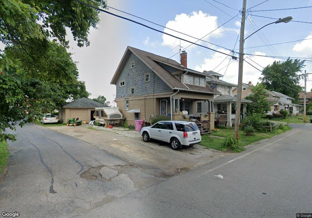
148 Bartley Ave Mansfield, OH 44903
Estimated Value: $54,000 - $100,000
3
Beds
1
Bath
1,251
Sq Ft
$67/Sq Ft
Est. Value
About This Home
This home is located at 148 Bartley Ave, Mansfield, OH 44903 and is currently estimated at $84,404, approximately $67 per square foot. 148 Bartley Ave is a home located in Richland County with nearby schools including Goal Digital Academy, Discovery School, and St. Peter's Elementary/Montessori School.
Ownership History
Date
Name
Owned For
Owner Type
Purchase Details
Closed on
Nov 23, 2019
Sold by
Humbert Kevin D and Humbert Debra J
Bought by
Keybank National Association
Current Estimated Value
Purchase Details
Closed on
Mar 26, 2019
Sold by
Humbert Kevin and Humbert Kevin D
Bought by
Humbert Kevin D and Humbert Debra J
Purchase Details
Closed on
Oct 17, 2006
Sold by
Miller John T and Miller Barbara L
Bought by
Humbert Kevin and Stumpf Michael
Create a Home Valuation Report for This Property
The Home Valuation Report is an in-depth analysis detailing your home's value as well as a comparison with similar homes in the area
Home Values in the Area
Average Home Value in this Area
Purchase History
| Date | Buyer | Sale Price | Title Company |
|---|---|---|---|
| Keybank National Association | -- | First American | |
| Humbert Kevin D | -- | Barristers Title Group | |
| Humbert Kevin | $40,000 | Barristers Title Group | |
| Humbert Kevin | -- | None Available |
Source: Public Records
Tax History
| Year | Tax Paid | Tax Assessment Tax Assessment Total Assessment is a certain percentage of the fair market value that is determined by local assessors to be the total taxable value of land and additions on the property. | Land | Improvement |
|---|---|---|---|---|
| 2024 | $570 | $11,910 | $2,720 | $9,190 |
| 2023 | $570 | $11,910 | $2,720 | $9,190 |
| 2022 | $531 | $9,300 | $2,330 | $6,970 |
| 2021 | $535 | $9,300 | $2,330 | $6,970 |
| 2020 | $547 | $9,300 | $2,330 | $6,970 |
| 2019 | $573 | $8,780 | $1,810 | $6,970 |
| 2018 | $588 | $9,130 | $1,810 | $7,320 |
| 2017 | $572 | $9,130 | $1,810 | $7,320 |
| 2016 | $473 | $7,320 | $2,490 | $4,830 |
| 2015 | $473 | $7,320 | $2,490 | $4,830 |
| 2014 | $446 | $7,320 | $2,490 | $4,830 |
| 2012 | $180 | $7,700 | $2,620 | $5,080 |
Source: Public Records
Map
Nearby Homes
- 158 Vennum Ave
- 31 Bartley Ave
- 133 Stewart Ave S
- 30 Douglas Ave
- 487 Davey Ave
- 116 Stewart Ave S
- 108 Stewart Ave S
- 189 Westwood Ave
- 455 Marion Ave
- 119 Carpenter Rd
- 24 Stewart Ave S
- 282 Vennum Ave
- 135 Wood St
- 81 Penn Ave
- 458 W West Dickson Ave
- 131 Sturges Ave
- 679 Coleman Rd
- 135 Fairlawn Ave
- 129 Fairlawn Ave
- 143 Fairlawn Ave
- 144 Bartley Ave
- 156 Bartley Ave
- 138 Bartley Ave
- 136 Bartley Ave
- 289 Marion Ave
- 153 Bartley Ave
- 147 Bartley Ave
- 168 Bartley Ave
- 139 Bartley Ave
- 145 Bartley Ave
- 159 Bartley Ave
- 305 Marion Ave
- 132 Bartley Ave
- 137 Bartley Ave
- 172 Bartley Ave
- 135 Bartley Ave
- 287 Marion Ave
- 176 Bartley Ave
- 176 Bartley Ave
- 171 Bartley Ave
Your Personal Tour Guide
Ask me questions while you tour the home.