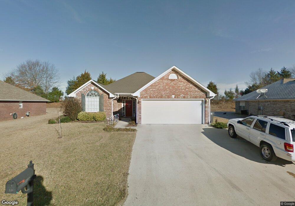
148 Colt Ln Guntown, MS 38849
Estimated Value: $208,000 - $257,434
3
Beds
2
Baths
1,668
Sq Ft
$143/Sq Ft
Est. Value
About This Home
This home is located at 148 Colt Ln, Guntown, MS 38849 and is currently estimated at $239,109, approximately $143 per square foot. 148 Colt Ln is a home located in Lee County with nearby schools including Saltillo Primary School, Saltillo Elementary School, and Guntown Middle School.
Ownership History
Date
Name
Owned For
Owner Type
Purchase Details
Closed on
Nov 15, 2022
Bought by
Kimery James and Kimery Chloe
Current Estimated Value
Purchase Details
Closed on
Jun 30, 2020
Bought by
Haire Bennie L
Home Financials for this Owner
Home Financials are based on the most recent Mortgage that was taken out on this home.
Original Mortgage
$163,975
Interest Rate
3.1%
Mortgage Type
FHA
Purchase Details
Closed on
Feb 3, 2016
Sold by
Feasel Steven and Feasel Jessica
Bought by
Larson Devin and Larson Jessica
Home Financials for this Owner
Home Financials are based on the most recent Mortgage that was taken out on this home.
Original Mortgage
$118,000
Interest Rate
3.97%
Mortgage Type
Purchase Money Mortgage
Purchase Details
Closed on
Mar 29, 2012
Sold by
Rakestraw Charles R and Rakestraw Holly S
Bought by
Feasel Steven Howard and Feasel Jessica L
Create a Home Valuation Report for This Property
The Home Valuation Report is an in-depth analysis detailing your home's value as well as a comparison with similar homes in the area
Purchase History
| Date | Buyer | Sale Price | Title Company |
|---|---|---|---|
| Kimery James | $210,000 | -- | |
| Haire Bennie L | $167,000 | -- | |
| Haire Bennie L | -- | None Available | |
| Larson Devin | -- | -- | |
| Feasel Steven Howard | -- | -- |
Source: Public Records
Mortgage History
| Date | Status | Borrower | Loan Amount |
|---|---|---|---|
| Previous Owner | Haire Bennie L | $163,975 | |
| Previous Owner | Larson Devin | $118,000 |
Source: Public Records
Tax History
| Year | Tax Paid | Tax Assessment Tax Assessment Total Assessment is a certain percentage of the fair market value that is determined by local assessors to be the total taxable value of land and additions on the property. | Land | Improvement |
|---|---|---|---|---|
| 2025 | $2,484 | $18,431 | $0 | $0 |
| 2024 | $2,484 | $18,431 | $0 | $0 |
| 2023 | $1,452 | $12,856 | $0 | $0 |
| 2022 | $1,407 | $12,856 | $0 | $0 |
| 2021 | $1,407 | $12,856 | $0 | $0 |
| 2020 | $1,703 | $12,856 | $0 | $0 |
| 2019 | $1,323 | $12,216 | $0 | $0 |
| 2018 | $1,333 | $12,216 | $0 | $0 |
| 2017 | $1,282 | $12,216 | $0 | $0 |
| 2016 | $1,233 | $12,216 | $0 | $0 |
| 2015 | $1,122 | $11,377 | $0 | $0 |
| 2014 | $1,122 | $11,377 | $0 | $0 |
Source: Public Records
Map
Nearby Homes
- 155 Colt Ln
- 124 Eunice Dr
- 204 Colt Ln
- 143 Eunice St
- 161 Benelli Dr
- 210 Pam Ave
- 1056 County Road 833
- 665 Mitchell Ave
- 125 Saint Thomas Dr
- 105 Lakeview Dr
- 111 Deanna Dr
- 138 Deanna Dr
- 0 Cr 2790 Lot 7
- 0 Cr 2790 Lot 10
- 0 Cr 2790 Lot 8
- 0 Cr 2790 Lot 6
- 0 Cr 2790 Lot 9
- 0 12 3 Acres Long Ave
- 0 Cr 2790 Lot 5
- 154 Cathryn Dr
Your Personal Tour Guide
Ask me questions while you tour the home.